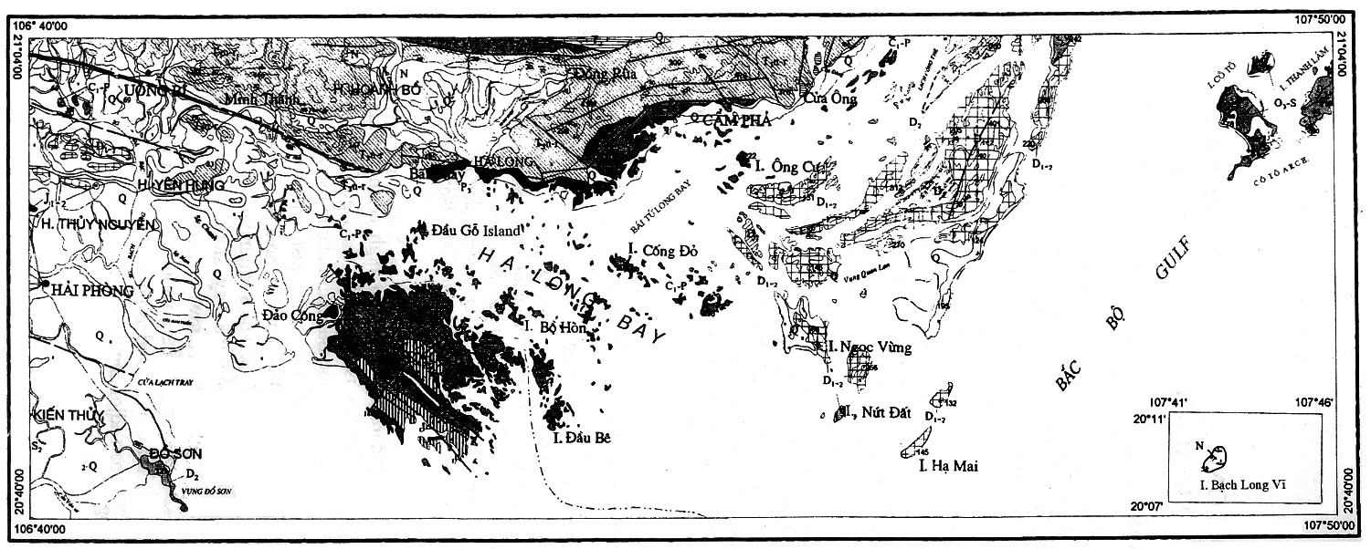
THE HẠ LONG BAY WORLD HERITAGE: OUTSTANDING GEOLOGICAL VALUES
TRẦN VĂN TRỊ1, TRẦN
ĐỨC THẠNH2, TONY WALTHAM3,1
National Committee for ICCP of Việt NamAbstract: In 2000, the UNESCO’s World Heritage Committee has inscribed the Hạ Long Bay in the World Heritage List according to its outstanding examples representing major stages of the Earth’s history and its original limestone karstic geomorphologic features. The Hạ Long Bay and its adjacent areas consist of a part of the Sino-Vietnamese composite terrane having its development history from pre-Cambrian up to present day. During Phanerozoic, terrigenous, volcanogenic and cherty-carbonate sediments containing in abundance graptolites, brachiopods, fishes, corals, foraminiferas, radiolarias, bivalves and flora, separated one from another by 10 stratigraphic gaps, but the boundary between Devonian and Carboniferous has been considered as continuous. The limestone karstic geomorphology of the bay was developed since Miocene, especially the cone-shaped hills (fengcong), or isolated high limestone karst towers (fenglin) with many remnants of old phreatic caves, old karstic foot caves, marine notch caves form magnificent limestone karst landforms as unique on the world. The Quaternary geology was developed through 5 cycles with the intercalation of marine and continental environments. The present Hạ Long Bay, in fact, appeared after the Middle Holocene maximum transgression, leaving ultimate zone of lateral undercutting in the limestone cliffs bearing many shells of oysters, having the 14C age as 2280 to >40,000 y. BP. Geological resources are abundant: anthracite, lignite, oil shale, petroleum, phosphate, limestone and cement additives, kaolin, silica sand, dolomite, quartzite of exogenous origin, and antimony, mercury of hydrothermal origin. Besides, there still are surface water, groundwater and thermal mineral water on the shore of the Hạ Long - Bái Tử Long Bays and other environmental resources.
INTRODUCTION
The Hạ Long Bay is situated in Northeast Việt Nam, belonging to the Quảng Ninh Province, adjoining to Hải Phòng City, with an area of 1553 km2, including 1969 islets. It has been incrisbed as sights of national category by the Ministry of Culture and Information in 1962, and as World Heritage in 1994 according to the 3rd criterion of the World Heritage Convention by having outstanding natural landscape of high aesthetic value. This bay is limited by the Đầu Gỗ Islet in the west, the Ba Hầm Lake in the south and the Công Tây in the east, with the central part of 434 km2 in area including 775 named islets. The surrounding buffer zone lying along the bay side, following the Highway 18A toward Quang Hanh (Cẩm Phả Town), has a width of 5-7 km with the sea or mainland as vicinity including the sea part adjoining the Cát Bà National Park.
According to the suggestion of Dr Hans Friederich, Chief of the Bureau representing the International Union of Conservation of the Nature (IUCN) at Hà Nội and the Managerial Commission of the Hạ Long Bay, Prof.Dr Tony Waltham of the Trent Nottingham University, UK has been carrying the study on the geology and the limestone karst of the Hạ Long Bay (1998). The Ministry of Culture and Information and the National Committee for UNESCO of Việt Nam have sent the record to the World Heritage Committee (WHC) at Paris in 12/1999. IUCN and WHC have sent Prof. Eleri Hamilton Smith to the Hạ Long Bay for establishing the verifying report on the authenticity of the above record (3/2000) and the 24th plenary session of the WHC at Cairns City of Queensland State, Australia has recognized the outstanding global value on geological history and limestone karstic geomorphology of the Hạ Long Bay according to the 1st criterion of the World Heritage Convention and adopted the proposal to inscribe the Hạ Long Bay to the World Heritage List with the absolute votes (2/12/2000).
Recently, the Prime Minister of Việt Nam has issued the Decision No.142/2002-TTg on the approval of planning to the year 2020 of preserving and displaying the value of the Hạ Long Bay Heritage; in this decision the area of direct study has been determined as 1553 km2, in which the Hạ Long Bay forms the centre and the area of indirect study including even the Cát Bà Island and the northern part of the Road No.18A surrounds it.
On the basis of existing materials the authors present briefly the outstanding values on geology of the Hạ Long Bay and adjacent areas and hope that by further studies other geological values will be certainly discovered.
GEOLOGICAL SETTINGS
The Hạ Long Bay and adjacent areas consist of a part of the Sino-Vietnamese composite terrane, which had passed through the processes of evolution, drifting, collision and change during pre-Cambrian - Phanerozoic.
The majority of the pre-Cambrian and Lower Paleozoic basement is covered and is exposed only in some places around the Bắc Bộ Gulf, but the Ordovician to recent formations are exposed rather fully on this area.
Along the Cô Tô Archipelago and Tấn Mài uplifted zones Ordovician-Silurian terrigeno-volcanic flyschoid formations of the marginal volcanic arc setting are strongly folded, forming the Quảng Ninh Geoanticline which was amalgamated into the Sino-Vietnamese Terrane during the process of collision and Caledonian orogeny. Devonian - Upper Paleozoic terrigenous-carbonate sediments lying unconformably upon them, exposed in the northwest of Bắc Bộ Gulf and Hải Phòng, Hải Dương, are asymmetrically folded and plunge under the Hạ Long Bay and Quảng Ninh Coast with a sloping attitude.
Superimposing the above structures, there is the An Châu Intracontinental Rift in the northwest and the Hòn Gai, Bảo Đŕi Mesozoic coal-bearing continental grabens which are the products of the Indosinian tectogenetic process, that became more complicated by the impact of the Jurassic - Late Cretaceous active continental margin. In the top there are Cenozoic structures, such as the Red River Pull-apart Basin, the Hoành Bồ and Bắc Bộ Gulf grabens which are petroleum- and coal-bearing basins, that were influenced by the sinistral strike-slip movement of the Red River Fault system and the formation of the East Việt Nam Sea.
The above geological settings create worldwide outstanding values on the historical geology, limestone karstic geomorphology, marine Quaternary geology and the diversification of geological resources of the Hạ Long Bay and adjacent areas.
VALUES OF HISTORICAL AND STRUCTURAL GEOLOGY
The development history of the Earth’s crust in the Hạ Long Bay is closely related to the regions situated around the Bắc Bộ Gulf and Southeast China.
During the pre-Cambrian (3000-750 Ma), the basement of granulite and amphibolite facies exposed in some areas of the Red River Basin, Hainan Island and Kwangtung passed through Late Archean tectonothermal stages of isotopic age as 2930-2840 Ma, Proterozoic ones – 2360-1960 Ma and 1790-970 Ma [35], collision and Grenvillian orogeny amalgamating the Cathaysia, Yangtse-Phansipan and Indosinian cratons with one another that were the components of the Rodinian supercontinent existing about 1000 Ma ago [11]. Then, the process of rifting took place for developing sedimentary basins, volcanic island arcs and forming the Gondwana Continent in about 550 Ma ago, and through many events a part was separated and accreted to the Asia Plate [11], including the Bắc Bộ Gulf and adjacent areas.
Neoproterozoic - Middle Paleozoic period (750-350 Ma). The similarity between biological provinces, paleomagnetism of Cambrian-Carboniferous geological formations in the Sino-Vietnamese and Indochinese, etc. composite terranes situated in the southern hemisprere together with Australia have been proving their Gondwanan origin. The sediments containing many kinds of paleontological remains and Phanerozoic magmatic formations having space and time relations forming the islands in the Hạ Long Bay and adjacent areas are rock historic pages recording the imprints of geological evolution in the interval from 550 Ma to present days.
The Cambrian - Early Ordovician sedimentary basin (550-465 Ma) contains many trilobites, brachiopods, etc. is largely distributed in North Việt Nam and South China; it is of shallow-sea environment in Hà Tuyên - Thanh Hóa and becomes deeper and deeper in East Bắc Bộ, Hainan Island, etc.. After a gap the Cô Tô and Tấn Mài forearc basins was formed including tuffaceous flyschoid formations, rich in calk-alkaline volcanoclastic materials olistostrom and turbidite with a thickness of over 1800 m, that were linearily strongly folded in NE-SW trend, containing the graptolites Demirastrites triangulatus, Spirograptus turriculatus, Pristiograptus cf. regularis, Monograptus ex gr. pandus, etc. of Llandoverian and Wenlockian age, Early-Middle Silurian (435-425 Ma), but their lower part is possibly of Late Ordovician age [20, 36]; these formations extend to the Yunkai island arc margin, Kwangtung, China. The sea gradually regressed to the present south for forming shallow shelf sediments: silty sandstone, clayey limestone attributed to the Kiến An Formation (S3-4 ka) with a thickness of >600 m dipping northeastwards. These sediments contain bottom fauna, such as brachiopods: Retziella weberi, Nikiforovaena vietnamensis, Howellella bragensis, etc., corals: Mesofavosites sp., Xiphelasma sp., Nipponophyllum sp., etc., bivalves: Schizodus kienanensis, Modiomorpha paracrypta, etc. of Late Ludlowian to Pridolian, Late Silurian (about 420-413 Ma), similar to the lower basin of the Đŕ River, or Quảng Bình of the Indochina Plate, which is near to the South China, Central Asia and East Australia plates [31].
The Early-Middle Paleozoic tectonic movement led to orogenic manifestations and magmatism from Middle Cambrian to Middle-Late Ordovician, especially to the process of collision and folding accompanied by granitoid intrusion at the end of Silurian (410 ± 20 Ma) forming the Sino-Vietnamese composite terrane, having the continental part enlarging southwards from Silurian to Devonian.
The Devonian - Early Carboniferous (410-340 Ma) sedimentary basin with the transgressive section from the continental, subcontinental molassic formation grading upward into terrigenous-carbonate-cherty sediments on the sea shelf lying unconformably upon the Cô Tô Formation (O3-S ct) exposed on the Trần Islet, and the Kiến An Formation (S3-4 ka). This formation forms a synclinal limb plunging northwestwards under the Hạ Long Bay and the Quảng Ninh Coast, and in its northeast direction it plunges towards Hải Phòng - Thủy Nguyên. Its lower part has been grouped into the Sông Cầu Group with the Mia Lé, Dưỡng Động and Đồ Sơn formations, 1000-1400 m thick, dated as Early-Middle Devonian on the basis of flora fossils Lepidodendropsis, Cooksonia, Eurypterid arthropods Rhinocarcinosoma, fishes Zhanjilepis, Vietnamaspis trii, Bothriolepis, Asterolepis, etc. (Fig. 2), brachiopods Lingula aff. yunnanensis, bivalves, etc. [8, 12], then come silty sandstone, clay shale, marl containing the brachiopods Euryspirifer cf. tonkinensis, Desquamatia desquamata, Acrospirifer sp. in the Ngọc Vừng Islet, the corals Syringopora eifeliensis, Amphipora vatustior, etc.. The middle part consists of limestone with some cherty shale subdivided into the Tràng Kênh and Bản Páp formations, 650 m thick, containing the corals Caliapora battersbyi, Amphipora ramosa in the Trà Bàn Islet, the brachiopod Stringocephalus burtini, etc. of Givetian age, the foraminiferas Tikhinella, Eotournayella, the corals Amphipora rudis, Stachyodes costulata of Frasnian age and the conodonts Palmatolepis triangularis, Pa. perlobata, Pa. subricata, Nothognathella abnormis, Apatognathus sp. of Early Famennian age [3,7, 48]. The upper part includes turbidite-like rhythmic limestone and cherty shale, subdivided into the Phố Hàn Formation (D3fm-C1 ph) containing foraminiferas in the Cát Bà Island, the Núi Voi Formation (C1 nv) in Kiến An and some islets in the northeast margin of the Hạ Long and Bái Tử Long Bays. Especially, the finding of the gradual D/C boundary including the conodont zone Palmatolepis gracilis, and the foraminifera zone Quasiendothyra konensis of Late Famennian grading upward into the beds containing Siphonodella sulcata, S. duplicata, Parathurammina suleimanovi and coral Syringopora distans, etc. of Early Tournaisian in the Cát Cò 3 Beach in the south of the Cát Bà Island [3, 48] is a rare evidence, having outstanding scientific value in the region and the world. Just in this exposure, the D/C boundary has the magnetic inductivity suddenly increasing in value (from 7 ´ 10-9 to 6 ´ 10-8) parallelly with the clear change of the tendency of displacement cycle of the magnetic induction, similar with the boundary of the same age in Spain, that shows the worldwide correlation of the process of sedimentary deposition [23].
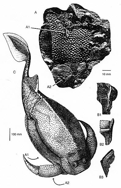
Figure 2. Fish fossil Asterolepis from the Trà Bàn Island (A, B); and reconstruction (C) [8]
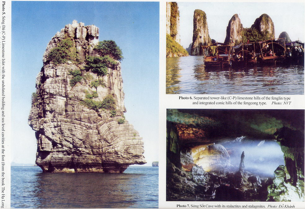
Late Paleozoic - Mesozoic period (350-65 Ma). After the stage of collision and amalgamation between the two Indochina and Sino-Vietnamese plates, the Late Paleozoic basin (350-250 Ma) was developed on the relatively stable shelf for forming carbonate-magnesian sediments largely distributed in Indochina and South China, at the same time existed some deep-sea depressions which are the branches of Paleo-Tethys extending to Northeast Việt Nam. These sediments comprise dolomitic limestone interbedded with oolitic limestone and calcaro-cherty shale attributed to the Bắc Sơn Formation (C-P bs), about 1000 m thick, exposed in many islands, islets and on the coast of the Hạ Long Bay, monoclinally or undulatedly folded (Photo 5) [7, 17, 25], containing foraminifera beds, from the Chernyshinella, Dainella, etc. to Cancellina, Neoschwagerina, Verbeekina Beds [7, 17, 25] together with remains of crinoids, corals, brachiopods , bivalves, bryozoans, etc.. At the same time, in Bãi Cháy, Hoành Bồ there are turbidite-like cherty shale members containing radiolarians Albailella paradoxa, A. undulata, Follicucullus bipartitus, etc. of from Carboniferous to Permian age determined by Wu Haoruo, that can be remains from a branch of Paleo-Tethys extending to Kwangtung, China [47]. Along the Hạ Long and Cẩm Phả coast there still are terrigenous-cherty sediments of the Bãi Cháy Formation (P2 bc) containing the brachiopods Productus gratiosus, Spiriferina cf. cambodgiensis, etc. and the foraminiferas Glomospira, Nankinella, etc. of Late Permian age [4, 25]. In the Late Paleozoic - Early Mesozoic stage, Hercynian-Indosinian tectonic activities created the collision between the Shan-Thai, Indochina and Sino-Vietnamese plates, as well as the spreading and intracratonal collision stirring up the paroxysmal event in Early-Middle Triassic (245 ± 10 Ma) influencing the whole area of this region. The East Bắc Bộ Basin (250-65 Ma) was gradually restricted forming the An Châu intracontinental rift in the west margin of Quảng Ninh filled up with porphyritic rhyolite and marine sediments containing ammonoids, bivalves attributed to the Bình Liêu (T2a bl) and Nà Khuất (T2 nk) formations, grading upward into continental red beds of the Mẫu Sơn (T3c ms) and Bản Hang (K bh) formations. At the end of Late Triassic the sea regressed toward the Hà Bắc - Thái Nguyên side forming the paralic coal seams in the Văn Lãng Formation (T3n-r vl) transiting in the Quảng Ninh coal basin into the lagoonal, continental facies of the Hòn Gai (T3n-r hg) and Hà Cối (J1-2 hc) Formations [4, 38].
The Hòn Gai Graben lying between the Trung Lương Fault Zone in the north and the Road No.18A Fault Zone in the south, on the Hạ Long - Cẩm Phả seaside includes subcontinental sediments containing many coal seams, 2200-3800 m thick [28, 38]. It is to note that the Hòn Gai Flora is wellknown on the world by its abundance and diversity with the groups of ferns, gymnosperms, etc. including 195 species, among them 62 species are endemic, 50 are still not fully studied yet. This flora has been subdivided into Taeniopteris nilssonioides Beds, T. spathulata Beds, Pecopteris tonquinensis Beds with some beds containing in abundance Bernoullia zeilleri, Otozamites obtusus, Anomozamites gracilis together with fresh-water, brackish-water faunas Estheria, Sibireconcha, and littoral bivalves Gervillia cf. inflata, Thracia sp. allowing to date the formation as Norian-Rhaetian [16, 40, 46].
The orogenic process continued to form the red continental molassic coarse clastic sediments of the Hà Cối Formation containing the plant remains of Coniopteris sp., Anomozamites sp., fresh-water bivalves Tutuella cf. kui, T. cf. nuculiformis of Early-Middle Jurassic age [18, 40] and the Bản Hang Formation containing the fresh-water bivalve Cyotrigonioides sp. (aff. C. longa) of Early Cretaceous age, unconformably resting upon older formations.
From Late Jurassic to the end of Cretaceous, the calk-alkaline hybrid volcano-plutonic arc of the active continental margin was formed on the subduction zone in the eastern margin of the Eurasia Plate, in which the East Bắc Bộ region passed through also the process of strong activation. At the same time, the Sundaland continent spreaded out in SE Asia, including the Bắc Bộ Gulf and the major part of the East Việt Nam Sea, in many places of which there were intermontane depressions, rivers, lakes and relict sea allowing to form evaporite-bearing formation in the arid and hot climate conditions.
Cenozoic period (65-0 Ma). Fluvio-lacustrine and deltaic sediments interbedded with shallow-sea beds were formed in the Red River pull-apart type rift with the thickness of about 4-15 km along the NW-SE sinistral strike-slip fault system and on the Bắc Bộ Gulf with the thickness of about 3-6 km extending on the NW-SE direction [30, 34]. According to seismic and drilling in petroleum exploration materials, these sediments were formed in the pre-rift stage: end of Cretaceous – Paleocene, synrift stage: Eocene – Late Oligocene, post-rift stage: end of Oligocene – Miocene, related to the spreading process of the East Sea floor (32 - 15.5 Ma), and inverse stage: Middle-Late Miocene with folding, erosion activities, and at last the continental shelf was formed with Pliocene-Quaternary sediments (5.5 - 0 Ma) unconformably resting upon a large and almost not deformed region [26, 29, 30].
Especially, these sediments exposed in Hoành Bồ and Bạch Long Vĩ Island still have manifestations of oil shale and asphaltite, containing in abundance sporomorphs Cicatricosisporites dorogensis, Verrutricolporites pachydermus, Pentapollenites maomingensis etc. of Oligocene age [27], remains of subtropical-humid vegetation Quercus cf. lobbii, Q. cf. neriifolia, Pecopteris totangensis, Acer trilobatum, Phragmites oeningensis, etc., the gastropod Viviparus cf. margaryaeformis, etc. of Mio-Pliocene age [37, 39]. Besides, there still are Quaternary basalt manifestations in some places, and since mid Holocene the system of island in the Bắc Bộ Gulf was formed.
On the structure side, one can distinguish the Vân Đồn Monoclinal Uplift, the Hạ Long Synclinal Subsidence, the Cát Bà Anticlinal Uplift separated from one another by the NW-SE and NE-SW fault systems [14, 24]; they adjoin the Hòn Gai Graben and the Hoành Bồ Depression through the sublatitudinal fault system, where, locally, there still are manifestations of current activity [15].
VALUES ON LIMESTONE KARSTIC GEOMORPHOLOGY
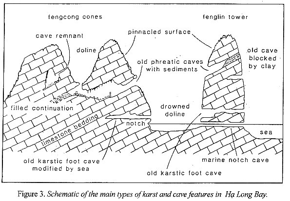
The Hạ Long Bay situated in the northwest margin of the Bắc Bộ Gulf, adjoining the Quảng Ninh - Hải Phòng Coast with coastal hilly and mountainous topography, is composed of many limestone relict mountains - islands lying above or under the sea level forming karstic and cave geomorphologic type having a worldwide reputation (Fig. 3, Photo 1).
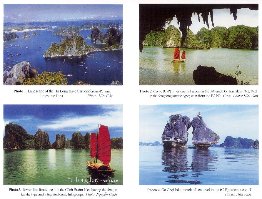
The geomorphology of the Hạ Long Bay is an excellent example on the mature karst thanks a rather homogenous limestone formation of about 100 m in thickness, existing in the hot, humid and rainy climate conditions, and on a general slow neotectonic uplift background, under the reciprocal impact between sea, earth and sky. The karstic evolution process in this bay, happening from Miocene (about 20 Ma ago) to present days, has passed through 5 stages: 1) formation of the ancient plain; 2) formation of karstic dolines and valleys; 3) formation of groups of conjunctive conic hills (fengcong, in Chinese) (Photos 2 & 3); 4) development of separated high towers with steep cliffs (fenglin, in Chinese) (Photos 5 & 6); 5) formation of new plain [32, 41-43], based on that the new term "Hạ Long type" has been proposed for characterizing the tropical limestone karst submerged by the sea.
Positive topographic forms. The direct studied area has a surface of 1553 km2 and 1969 islands and islets with the density of 1.27 island/km2, including super-small (0.0001 - 0.01 km2) and very small (0.01 - 0.1 km2) relict hills-islets occupying up to 91.5% of the total amount of islands and islets, but only 25.70% of the total island surface. There are only 7 islands having the surface of over 1 km2, among them the largest is the Hang Trại of 4.613 km2. In the Hạ Long Bay area 1 ha of island surface corresponds to 9 ha of sea surface.
The west island band comprises 7 island groups (Table 1); according to the quantity, shape, size and combination of the islands one can use the two following indices: K and I.
K = quantity of separated conic islets and towers divided to the island amount;
Kmax = 1, when all the islands and islets are of separated conic and tower shape;
I = conic tower index; I = h/R,
with h = height of relict mountain - island; R = radius of the island base, with the agreement that this base is converted to a circle.
Table 1. Quantity of islands and islets subdivided into the conic and tower shapes, and the K index
|
No |
Name of the islet groups |
Quantity of conic, tower-like |
Quantity of islets in the remnant mountain range form |
Total sum of islands and islets |
K |
||
|
Separated |
Integration of 2 |
Integration of 3 |
|||||
|
1 |
Đầu Gỗ |
3 |
2 |
2 |
1 |
8 |
0,37 |
|
2 |
Chân Voi - Vạn Bội |
20 |
9 |
3 |
3 |
35 |
0,57 |
|
3 |
Dầm Nam |
6 |
2 |
1 |
1 |
10 |
0,60 |
|
4 |
Lờm Bò |
15 |
3 |
1 |
2 |
21 |
0,71 |
|
5 |
Bồ Hòn |
33 |
6 |
3 |
2 |
44 |
0,75 |
|
6 |
Hang Trại |
36 |
5 |
3 |
1 |
45 |
0,80 |
|
7 |
Đầu Bê |
27 |
6 |
3 |
1 |
37 |
0,73 |
|
|
|
140 |
33 |
16 |
11 |
200 |
Kav 0,70 |
The K index varies from 0.37 in the Đầu Gỗ Group to 0.80 in the Hang Trại Group, and in average K = 0.70, i.e. every 10 islets there are 7 of separated conic, tower-like and dome shapes, that increases towards the offshore. The feature of the morphology index of the islet group has been showing that the Bồ Hòn, Hang Trại and Đầu Bê islet groups situated far from the seaside have more numerous separated conic, tower-like islets and more characteristic with the Imax = 2.40 and Imin = 0.12.
On the height of the topographic steps the 92 islets in the Đầu Gỗ and Đầu Bê bands can be divided into 3 groups: 1) 140-220 m (140-160; 170-190; and 200-220 m) with the highest summits, possibly, corresponding to the Pliocene planation surface; 2) 50-130 m (50-60; 70-90; and 100-130 m) being the most widespread height occupying 59% of
the total sum, reflecting the development stage at the beginning of Quaternary; and 3) 10-14 m, being the topographic step directly influenced by the sea, possibly, in Late Pleistocene - Holocene.
Negative topographic forms. The karstic dolines, pits and closed valleys of isometric, ellipsoid or semicircular shape of different sizes with the base lying in the height of about 5 m, are widespread in the Hạ Long Bay and the Cát Bà Island. Due to the cover of the sea water, the major part of them are transformed into lakes and lagoons. There are about 62 closed karstic lakes lying in the centre of islands, among them the largest is Vẹm Lake (28.8 ha), and the smallest – Trề Môi Lake (0.7 ha); the lakes are usually 1-3 m deep [46].
The submerged karstic valleys and ravines form small lagoons penetrating deeply in limestone islands. According to the statistics, in the Hạ Long and Cát Bà areas there are 57 such lagoons, among them the largest is the Gấu Lagoon (220 ha) and the smallest – Mây Đen Lagoon (1.5 ha).
Caves. In the Hạ Long Bay caves are abundant and diverse. Up to present time, 24 caves have been registered, about some tens to some hundreds metres, distributed in 3 levels: level 1 – 3-4 m high, related to the present sea level; level 2 – 5-15 m high, usually having greatest size; level 3 – 25-50 m high, such as Thiên Cung and Mê Cung caves. In general, high caves have older forming age, among them the major part of caves of the level 2 and 3 were, possibly, formed in Pleistocene. Caves in the Hạ Long Bay can be subdivided into 3 main groups [32, 41-43].
l. Old caves: the major part of old caves are drainage way from old karstic dolines having considerable difference in height. The Sửng Sốt Cave (Photo 7) on the Bồ Hòn Island is a large cave of 10 m in height. The Tam Cung Cave comprises 3 chambers of 20 m different in height, developed in accordance to the bedding of limestone. The Lâu Đŕi Cave on the Cổ Ngựa Island consists of a system of passages of 300 m in length. The Thiên Cung and Đầu Gỗ caves are remnants of a same old cave lying the height of 20-50 m, among them the Thiên Cung Cave is a large chamber of over 100 m in length separated by stalactite walls into many smaller chambers, but the Đầu Gỗ Cave is a large tunnel lowering along a system of fissures.
2. Group of old karstic foot caves: generated when the erosion enlarges horizontally at the foot level. These caves have the nearly horizontal passage related to abraded or accumulated marine terraces lying equally to the foot level. Trinh Nữ is the largest foot cave in the Hạ Long Bay with the ceiling of 12 m in height, 80 m in length and developed through many stages. Bồ Nâu is a 70 m long horizontal cave with many old stalactites and stalagmites.
3. Group of marine notch caves: formed by the dissolution process of sea water, waves and tides according to the usual chemical reaction: CO2 + CaCO3 + H2O à Ca++ + 2(HCO3). They usually have the horizontal ceiling formed in the present sea level, as well as during sea transgression in Holocene, even in Pleistocene. Some caves in the Ba Hầm Lake area includes an association of 3 caves connecting 3 lakes of saline water with one another and communicating to the sea. The most outside cave is 150 m long, 10 m wide. The Luồn Cave on the Bồ Hòn Island is 50 m long having the ceiling 2 m higher than the high tide.
Sea notches. These hollow notches occur in the limestone cliffs, caused by the corrosion of sea water and the impact of waves making the conic and tower-like islet to be smaller at the foot, that increases the original aspect of the karstic landscape of the bay (Photos 4 & 5). The sea notches occur in different heights, from 2-2.5; 3-5; 7-8 to 9-12 m, among them many notches still keep the shell of oyster and sea-acorn which can give the age of each notch, i.e. of the sea level corresponding to this notch, by the 14C isotopic age analysis. This will be given below.
Submerged karstic valleys and plains. The submerged karstic valleys form waterways, most of them are of NW-SE trend, extending 5-10 km, with a depth of 10-20 m. The floor of the Hạ Long Bay consists of a karstic plain lying in the depth of 3-20 m, the surface of which is complicated with many relict mounds, furrows, ditches of clear stepping character: 1-4; 6-11 and 12-20 m, reflecting the abrasion-corrosion stages before submersion; in many places there are reef-forming corals. This karstic plain, formed since Middle Holocene, has an island system surrounding it therefore, is not subjected to the impact of wave, and due to the high amplitude of tides (4 m in maximum) there are both accumulation and erosion [22].
VALUES ON QUATERNARY GEOLOGY AND MARINE GEOLOGY
The Quaternary geology of the Hạ Long Bay is close related to the formation of the Bắc Bộ Gulf and the Red River Delta. In the coastal zone of East Bắc Bộ and on some islands there still are the remains of terraces at the height of 45-65; 20-30; 10-15; 4-6 and 1.5-3 m [5, 19, 21], and on the floor of the Bắc Bộ Gulf there are sediments accumulated in the topographic steps of the zone of beach braking waves of 5 m in depth, zone of destroying-deforming waves – 5-0 m; zone of spreading waves – 20-30 m; and accumulated plain of the old deltaic type – 80-110 m, developed in the Late Pleistocene stage [22].
At the same time, in the Red River Plain and on the Hải Phòng - Quảng Ninh Coastal Zone the Early Pleistocene and Middle-Late Pleistocene sedimentary cycles belong mainly to the fluvio-proluvial facies with some Late Pleistocene, Late Pleistocene - Middle Holocene lagoonal facies. The maximum transgression and Late Holocene stage is composed of fluvio-lacustrine, marshy, deltaic-littoral and eolian facies containing remains of molluscs, foraminiferas, etc.. All these Quaternary sedimentary cycles happened together with the glacial cycles Gunz (1.6 Ma), Mindel (700,000 y.), Riss (125,000 y.) and Wurm (20,000 y.), and the Flandrian transgression happening in about 5000 y. ago [13, 34]. In general, the continent dominated during Pleistocene, but there have been having some transgressions determined by the finding of foraminiferas in boreholes drilled at Hải Phòng, Vĩnh Bảo, etc., however, to Holocene the marine environment dominated [2]. The appearance of the Hạ Long Bay can be divided into 6 stages [10, 33].
1. Beginning of Late Pleistocene - Holocene (11,000-7000 y.BP) transgression to the marginal zone of the Bắc Bộ Gulf at the depth of about 60 m moving gradually towards the south of the Hạ Long Bay (8000-7000 y.BP).
2. Holocene maximum transgression (7000-4000 y.BP), giving the appearance of the Hạ Long Bay.
3. Middle-Late Holocene regression (4000-3000 y.BP), leading to the manifestation of the relief rise and the development of lateritic weathering.
4. Sea ingression (3000-2000 y.BP), leading to the partial enlargement of the Hạ Long Bay.
5. Restriction of the Hạ Long Bay (2000-1000y.BP), leading to the development of mangrove marshes under the influence of alluvion of the Red and Bạch Đằng river systems.
6. Beginning of enlargement of the Hạ Long Bay (1000 y. ago) due to the rise of the oceanic water level with the strong activity of tidal flows.
Related to the formation and development of the Hạ Long Bay, the cultural history of this coastal zone was developed long ago. The Soi Nhụ Culture (25,000-7000 y.BP) has been found in the caves on the islands of the Hạ Long - Bái Tử Long Bays (14C age: 14,125 ± 180 y.BP) that are more developed than the Hòa Bình and Bắc Sơn cultures; the Cái Bèo Culture (7000-5000 y.BP) has been found in out of the wind bay side (14C age: 5645 ± 60 y.BP); the Hạ Long Culture (4500-3500 y.BP) found in Tràng Kênh and the Bạch Đằng River mouth areas (14C age: 3406 ± 100 y.BP) that has been subdivided into two early and late stages [6, 33].
The Middle-Late Holocene lowering of sea level in the Hạ Long Bay has been leaving hollow notches of waves in the limestone cliffs where there still are remained the shells of oysters, sea-acorns, sea-worms, gastropod Meladani, etc. that have been giving the following 14C age, analyzed at the notch of 3.5 m of the Cầu Ngư Islet: 2280 ± 60 and 3820 ± 50 y.BP; at the notch of 4.25 m: 3280 ± 60 y.BP; at the notch of 4.55 m: 4100 ± 50 y.BP; at the notch of 4.85 m: 4990 ± 90 y.BP; and at the notch of 4.90 m: 4050 ± 140 y.BP; near the Đầu Giếng Cụt Islet, at the notch of 7.05 m: > 40,000 y.BP, at the notch of 7.80 m: 32,960 ± 680 y.BP; in Quang Hanh, at the notch of 5.3-5.5 m: 4420 ± 70 y.BP; at the notch of 9.1-10.1 m: > 40,000 y.BP [1]. These notches of waves change in height are generated not only from the change of the sea level, but also from the neotectonic movement.
VALUES ON GEOLOGICAL RESOURCES
Geological resources in the Hạ Long Bay and adjacent areas are abundant in type and diversified in origin with main types, which have been explored and exploited [7, 18, 38, 45].
Fuel resources. The Quảng Ninh Coal Basin is wellknown long ago. The coal of this basin suffered the high metamorphism and became anthracite, which has been exploited during over 100 years. The coal-bearing formation includes from 2 to 58 coal seams with the mean thickness of some metres (Dày pencil of seams at Lộ Trí: 92.2 m), having the total resource as 10 billions tons, among it the explored and reserve calculated is over 2 billions tons of high quality coal giving the average calorie as 8050 kcl/kg. Besides, there still is natural gas, such as methane, nitrogen, carbonic acid gas, etc., locally reaching up to 25-30 m3/t of coal. Lignite and bituminous coal exist in Tertiary basin of the Bắc Bộ Gulf, especially, in the Hà Nội Depression of the Red River Delta 115 seams have been estimated with the forecasted total resource of about 250 billions tons.
Oil and gas of great potentiality in the Red River and Bắc Bộ Gulf basins are being investigated. Oil shale in Đồng Ho (north of Hạ Long) has been explored, giving the reserves of 4204 millions tons with the oil content of 5.7 - 12.65%.
Construction material resources. Limestone, as a cement raw material, occurs in many places with large scale, good quality (CaO » 53.85%; MgO » 0.25%; Fe2O3 » 0.12 %, etc.), and the reserves of hundreds millions tons. Besides, there is clay as additive in cement production, obtained from weathered clay shale and formation of loose sediments. Tile and brick clay from the Giếng Đáy Mine (Hoành Bồ) is wellknown by its high quality (SiO » 70.56%; Al2O3 » 14.16%; Fe2O3 » 4.56%; CaO » 0.15%, etc.). In addition, there still are many construction stones, such as facing stone, freestone, limestone for lime production, quartzite, as well as quartz aggregate found on the shore and in the sea.
Ceramic, refractory glass raw materials. Kaolin in this area is the weathering product of feldspar-rich sediments of the Hòn Gai (T3n-r hg) and Đồng Ho (E3 dh) formations, of porphyritic rhyolite (T2a) and of keratophyre (D); it is of good quality. The glass sand deposit in the Vân Hải Island contains silica sand of regular granulity (0.1-0.4 mm) with SiO2 » 99.1%, of eolian-marine origin forming a sand dune band of 3-4 km in length with the reserves of over 10 millions tons. Besides, there still is refractory clay from coal-bearing formation (T3), dolomite (D2-3, C-P), quartzite (D1-2), etc..
Mineral fertilizer resource. Precipitated phosphorite in (C-P) limestone caves and karstic dolines at Hoành Bồ, along the Road No.18A and on some islands of the Hạ Long Bay has the P2O5 content of » 8%. Peat from Holocene sediments at Thủy Nguyên, An Hải, etc. has the coastal-marshy origin.
Basic metals. Beside some deposits of antimony in Đồng Mỏ, Khe Chim, Dương Huy there still are arsenopyrite, fluorite, pyrite and gold. Mercury under the form of cinnabar impregnated in cataclastic rocks of chert-limestone in the Hoành Bồ Deposit is unknown in perspective.
Water resource. Beside the surface water and groundwater in the coastal zone and on some islands, in Quang Hanh mineral water occurs near the high tide level and in some boreholes. It is of the brome type, a bit hot (25-45oC), of the sodium chloride chemical type and of high mineralization ([mg/l]: Br = 20.5-49; H4SiO4 = 22; Sr = 4.2; pH = 7.4, etc.), transparent, without odour, of salt taste, with the total mineralization of 2.7 g/l.
In addition, in the Hạ Long Bay there still is the environment resource, such as the landscape, population community of some nations, return of the daily tides of high amplitude, biological diversity of ecological system on the islands, the bay of hard or soft floor, coral reefs, mangrove forest, archeological sites, etc., but the most attractive is the tourism resource.
In short, the Hạ Long Bay has been internationally recognized through the inscription by UNESCO to the List of World Heritage with the aesthetic value as a grandiose and illusory natural chef d’oeuvre, and has been receiving the second coronation on the value of historical geology, especially, the limestone karst geomorphology and caves in the common setting of earth-sky-sea, that makes the bay to become an matchless site in the world.
For the sustainable development of the Hạ Long Bay World Heritage, we all need to preserve it and maximally restrict the danger caused by environmental impact, such as the discharge of overburden and poor rocks during the coal exploitation to the bay, discharge of construction materials, etc., discharge of urban wastes, activity of navigation and port, destruction of mangrove forest, touristic industry, etc. for protecting the outstanding on the world values of special quality for the interest of all the mankind.
In the end, the authors would like to express their sincere thanks to the Việt Nam National Committee for UNESCO, the Commission of Management for the Hạ Long Bay by the receipt of many related references, and to the Professors Tống Dzuy Thanh and Vũ Khúc for their precious contribution to this paper.
REFERENCES
1. Doãn Đěnh Lâm, Boyd W.E., 2002. Tài liệu về đợt hạ thấp mực nước biển trong Holocen giữa-muộn ở vịnh Hạ Long (Materials on the lower of the sea level during Middle-Late Holocene in the Hạ Long Bay). TC Địa chất, A/270 : 1-7. Hà Nội.
2. Đinh Văn Huy, Trần Đức Thạnh, Nguyễn Đức Cự, 1985. Về sự hình thành của đảo Cát Hải (On the formation of the Cát Hải Island). Những phát hiện mới Khảo cổ học 1985 : 18-20. Hà Nội.
3. Đoŕn Nhật Trưởng, Tạ Hòa Phương, Nguyễn Minh Phương, 2003. Về việc phân chia địa tầng các trầm tích Devon thượng và Carbon hạ ở vùng duyên hải Đông Bắc Bộ (On the stratigraphic subdivision of Upper Devonian - Lower Carboniferous sediments in the coastal zone of East Bắc Bộ). TC Địa chất, A/276 : 1-9. Hà Nội.
4. Đovjikov A.E. (Editor), 1965. Geologija Severnogo Vietnama (Geology of North Việt Nam). Glavn. Geol. Upravlenie, Hà Nội (in Russian).
5. Đỗ Tuyết, Hoàng Hữu Quý, Lâm Thanh, Trần Văn Trị, Phạm Khả Tùy, Nguyễn Đěnh Uy, 1976. Về sự có mặt các thềm biển ở đảo Bạch Long Vĩ (On the presence of marine terraces on the Bạch Long Vĩ Island). TC Địa chất, 127 : 15-17. Hà Nội.
6. Hà Hữu Nga, Nguyễn Văn Hảo, 1998. Hạ Long thời tiền sử (Hạ Long in the pre-historic time). Nxb Thế giới, Hà Nội, 319 tr..
7. Hoàng Ngọc Kỷ (Chủ biên), 2001. Địa chất và khoáng sản tờ Hải Phòng tỷ lệ 1:200.000 (Geology and mineral resources of the Hải Phòng map sheet at 1:200,000 scale). Cục Địa chất và Khoáng sản Việt Nam, Hà Nội, 90 tr..
8. Janvier P., Racheboeuf P., Nguyễn Hữu Hùng, Đoŕn Nhật Trưởng, 2003. Devonian fish (Placodermi, Antiarcha) from Trà Bàn Island (Bái Tử Long Bay, Quảng Ninh Province, Việt Nam) and the question of the age of the Đồ Sơn Formation. J. Asian Earth Sci., 21 : 795-801. Pergamon.
9. Lê Đức An, 1972. Phương pháp luận thành lập Bản đồ địa mạo Bắc Việt Nam trên cơ sở phân tích kiến trúc hình thái và chạm trổ hình thái (Methodology of the compilation of the Geomorphologic Map of North Việt Nam on the basis of morphostructure and morphosculpture analysis). Tt luận án PTS Địa lý, Moskva, 22 tr. (in Russian).
10. Lê Đức An, 1996. Về dao động mực nước biển ở thềm lục địa ven bờ Việt Nam trong Holocen (Oscillation of Holocene sea level in the Việt Nam continental shelf). TC Khoa học Trái đất, 18/4 :365-367. Hà Nội.
11. Li Z.X., Li X.H., Wang J., Evans D.A.D., Kinny P.D., Zhang S., Zhou H., and Ling W., 2001. South China in Rodinia: An update. Gondwana Res., 4/4 : 685-686.
12. Long J.A., Burrett C., Phạm Kim Ngân, Janvier P., 1990. A new bothriolepid antiarch (Pisces, Placodermi) from the Devonian of Do Son Peninsula, northern Việt Nam. Alcheringa, 14 181-191.
13. Ngô Quang Toàn (Chủ biên), 2000. Vỏ phong hóa và trầm tích Đệ tứ Việt Nam (Weathering crust and Quaternary sediments in Việt Nam). Cục Địa chất và Khoáng sản Việt Nam, Hà Nội, 269 tr..
14. Nguyễn Biểu, Trịnh Thanh Minh, Nguyễn Chung Hoạt, Hoàng Văn Thức, Nguyễn Tiến Cường, Lê Việt Nam, 1999. Cấu trúc địa chất vùng biển Hải Phòng - Quảng Ninh (Geological structure of the Hải Phòng - Quảng Ninh sea area). Tóm tắt BCKH HN KHCN biển, II : 54-60. Hà Nội.
15. Nguyễn Cẩn, Nguyễn Đěnh Hòe, Trần Đức Thạnh, Nguyễn Đức Cự, Nguyễn Hữu Cư, Nguyễn Chu Hồi, 1994. Hoạt động đứt gãy hiện đại vùng Hải Phòng - Quảng Yên (Recent faulting activity in the Hải Phòng - Quảng Yên). Tài nguyên và môi trường biển, II : 54-60, Nxb KH&KT. Hà Nội.
16. Nguyễn Chí Hưởng, Đặng Trần Huyên, 1990. Cổ sinh và địa tầng bể than Quảng Ninh (Paleontology and stratigraphy of the Quảng Ninh Coal Basin). Địa chất và khoáng sản, 3 : 167-180. Viện NCĐC & KS, Hà Nội.
17. Nguyễn Công Lượng (Chủ biên), 2001. Địa chất và khoáng sản tờ Hạ Long (Hòn Gai) tỷ lệ 1:200.000 (Geology and mineral resources of the Hạ Long (Hòn Gai) Map sheet at 1:200,000 scale). Cục Địa chất và Khoáng sản Việt Nam, Hà Nội, 64 tr..
18. Nguyễn Công Lượng (Chủ biên), 2001. Địa chất và khoáng sản tờ Móng Cái tỷ lệ 1:200.000 (Geology and mineral resources of the Móng Cái Map sheet at 1:200,000 scale). Cục Địa chất và Khoáng sản Việt Nam, Hà Nội, 60 tr..
19. Nguyễn Địch Dỹ, Mai Thanh Tân, 1996. Vài nét về địa chất - địa mạo bờ biển Việt Nam (Some features of geology and geomorphology of the Vietnamese coast). Địa chất tài nguyên, 1 : 278-283. Hà Nội.
20. Nguyễn Huy Mạc, Phạm Thế Hiện, 1972. Một số vấn đề địa chất ở quần đảo Cô Tô và lân cận trong vịnh Bắc Bộ (Some problems of geology on the Cô Tô Archipelago and adjacent areas in the Bắc Bộ Gulf). TS Sinh vật - địa học, XI/4 : 37-42, Hà Nội.
21. Nguyễn Ngọc, 1998. Stratigraphy and development history of the northwestern island system of the Bắc Bộ Gulf. Contr. to marine geol. and geophysics, IV : 38-51. Sci. & Techn. Publ. House, Hà Nội.
22. Nguyễn Thế Tiệp, Phạm Tuấn Huy, Trần Xuân Lợi, Nguyễn Quốc Hưng, Vũ Thị Thu Hoài, Lê Đěnh Nam, 2003. Đặc điểm địa mạo đáy vịnh Bắc Bộ (Geomorphologic characteristics of the Hạ Long Bay floor). Tt CTNC Địa chất và địa vật lý biển, VII : 15-28. Hà Nội.
23. Nguyễn Thị Kim Thoa, Ellwood B.B., Phạm Kim Ngân, Vũ Hồng Nam, Lưu Thị Phương Lan, 2002. Sử dụng số liệu đo độ từ cảm xác định ranh giới Devon-Carbon trên các đá trầm tích tại đảo Cát Bà và Núi Voi, Kiên An (Using data of measuring the magnetic inductivity for determining the Devonian/Carboniferous boundary in sedimentary rocks on the Cát Bà Island and in the Núi Voi area, Kiến An). TC Khoa học Trái đất, 27/1 : 56-66. Hà Nội.
24. Nguyễn Văn Giáp, Phùng Văn Phách, 2000. Đặc điểm cấu trúc và địa động lực của các hệ đứt gãy ven rìa khu vực vịnh Bắc Bộ (Structural and geodynamic characteristics of fault systems in the margin of the Bắc Bộ Gulf). Tt CTNC Địa chất và địa vật lý biển, IV : 123-131. Hà Nội.
25. Nguyễn Văn Liêm, 1985. Paleozoi thượng ở Việt Nam (Upper Paleozoic in Việt Nam). Nxb KH&KT, Hà Nội, 532 tr..
26. Phạm Năng Vũ, 2000. Quá trình biến dạng của đới đứt gãy Sông Hồng (Deformation process of the Red River Fault Zone). TC Khoa học Trái đất, 22/4 : 278-289. Hà Nội.
27. Phạm Quang Trung, Đỗ Bạt, Nguyễn Quốc An, Đặng Vũ Khởi, Đỗ Việt Hiếu, Nguyễn Địch Dỹ, 2000. New palynologic discoveries in Tertiary sediments in Northern Sông Hồng Basin and adjacent areas. Geology and Petroleum in Việt Nam : 68-81. Việt Nam Oil & Gas Corp., Hà Nội.
28. Phạm Văn Quang, 1973. Cấu trúc địa chất chủ yếu của bể than Đông Bắc Bắc Bộ (Main geological structures of the East Bắc Bộ Coal Basin). TS Sinh vật - địa học, XI/3-4 : 73-90. Hà Nội.
29. Phan Trung Điền, Nguyễn Huy Quý, Phạm Văn Tiêm, Phùng Sỹ Tài, C. Andersen, L.H. Nielsen, 2000. Basin analysis and petroleum system of the Red River Basin. Geology and Petroleum in Việt Nam : 44-67. Việt Nam Oil & Gas Corp., Hà Nội.
30. Rangin C., Klein M., Roques D., Le Pichon X., Lê Văn Trương, 1995. The Red River fault system in the tonkin Gulf, Việt Nam. Tectonophysics, 243 : 209-222.
31. Tong Dzuy Thanh, Boucot A.J., Rong J.Yu., Pang Z.J., 2001. Late Silurian marine shelly fauna of Central and Northern Việt Nam. GEOBIOS, 34/3 : 315-338.
32. Trần Đức Thạnh, Waltham T., 2001. The outstanding value of geology of Hạ Long Bay. Advance in Nat. Sci., 2-3 : 89-99.
33. Trần Đức Thạnh, 1998. Lịch sử địa chất vịnh Hạ Long (Geological history of the Hạ Long Bay). Nxb Thế giới, Hà Nội, 94 tr..
34. Trần Nghi, Chu Văn Ngợi, Đinh Xuân Thành, Nguyễn Đěnh Nguyên, 2000. Tiến hóa trầm tích Kainozoi bồn trũng Sông Hồng trong mối quan hệ với hoạt động kiến tạo (Evolution of Cenozoic sediments of the Red River Depression in the relation with tectonic activities). TC Khoa học Trái đất, 22/4 : 290-305. Hà Nội.
35. Trần Ngọc Nam, Toriumi M., Sano Y., Tereda K., T.T. Thắng, 2003. 2.9, 2.36 and 1.96 Ga zircon in orthogneiss south of the Red River shear zone in Việt Nam: Evidence from SHRIMP U-Pb dating and tectonothermal implications. J. Asian Earth Sci., 21 : 734-753. Pergamon.
36. Trần Văn Trị, Nguyễn Đěnh Uy, Trần Đěnh Nhân, Đỗ Tuyết, 1972. Tài liệu mới về cấu tạo địa chất quần đảo Cô Tô (New materials on the geological structure of the Cô Tô Archipelago). Địa chất, 105 : 1-4. Hà Nội.
37. Trần Văn Trị, Nguyễn Đěnh Uy, Đỗ Tuyết, Hoàng Hữu Quý, Lâm Thanh, Phạm Khả Tùy, 1972. Địa chất đảo Bạch Long Vĩ (Geology of the Bạch Long Vĩ Island). Địa chất, 132 : 1-11. Hà Nội.
38. Trần Văn Trị (Chủ biên), 2000. Tài nguyên khoáng sản Việt Nam (Mineral resources of Việt Nam). Cục ĐC và KS Việt Nam, Hà Nội, 214 tr..
39. Trịnh Dánh, 1998. Biostratigraphy, biofacies and paleogeography of the Neogene sequences in Việt Nam. J. Geology, B/11-12 : 123-135. Hà Nội.
40. Vũ Khúc (Chủ biên), 2000. Sách tra cứu các phân vị địa chất Việt Nam (Lexicon of geological units of Việt Nam). Cục ĐC và KS Việt Nam, Hà Nội, 430 tr..
41. Waltham T., 1998. Limestone karst of Ha Long Bay, Viet Nam. Eng. Geol. Rep. 806 : 1-14. Nottingham Trent Univ., London.
42. Waltham T., 2000. Karst and caves of Ha Long Bay, a World Heritage Site of international significance. Intern. Caver, 2000 : 24-31. Swindon, UK.
43. Waltham T., Hamilton-Smith E., 2004. Ha Long Bay. In Gunn J. (ed) Encyclopedia of Caves and Karst Science, 413-414. Routledge, New York & London.
44. Zeiller R., 1903. Sur la flore fossile des gites de charbon du Tonkin. Etude des gites min. de la France, 1 : 328 p.. Paris.
45. Zhang Boyou, Zhang Haixiang, Chen Guiping, Yang Shufeng, Chen Hanlin, 2001. Evidence for the paleo- Tethyan tectonic belt in Western Guangdong and Eastern Guangxi, China. Gondwana Res., 4/4 : 839.
IN ARCHIVES
46. Lại Huy Anh (Chủ biên), 1999. Đặc điểm địa chất, địa mạo phục vụ quy hoạch phát triển du lịch khu vực vịnh Hạ Long - Cát Bà (Geological and geomorphologic features for serving the planning of touristic development in the Hạ Long - Cát Bà area). Lưu trữ Viện Địa lý, Trung tâm KHTN & CNQG, Hà Nội.
47. Ngô Quang Toàn (Chủ biên), 1995. Địa chất và khoáng sản thành phố Hải Phòng tỷ lệ 1:50.000 (Geology and mineral resources of the Hải Phòng City at 1:50,000 scale). Lưu trữ Địa chất, Hà Nội.
48. Phạm Kim Ngân (Chủ biên), 2001. Nghiên cứu cổ sinh địa tầng và tướng đá cổ địa lý các trầm tích Devon thượng - Carbon hạ Bắc Việt Nam (Studying on the biostratigraphy and paleogeographic lithological facies of Upper Devonian - Lower Carboniferous in North Việt Nam). Lưu trữ Địa chất, Hà Nội.