A NEW KINEMATIC MODEL FOR THE CENOZOIC DEFORMATION ALONG THE RED RIVER SHEAR ZONE: IMPLICATION FOR THE SÔNG HỒNG BASIN FORMATION
NGUYỄN
VĂN VƯỢNG, TẠ TRỌNG THẮNG, VŨ VĂN TÍCHViệt Nam National University, Hà Nội, 334, Nguyễn Trãi Road, Thanh Xuân, Hà Nội
Abstract: The kinematic model presented in this paper attempts to interpret the published data along the Red River shear zone on land as well as in its end in the Bắc Bộ (Tonkin) Gulf of Việt Nam in a new way. As proposed in the present model, the Indochina Block extruded southeastward between 30-15 Ma on a small circle but it intersects the Red River fault trace. Accordingly, the NW part of the intersection suffers from a compression-left-lateral motion meanwhile the NE segment is subjected to NE-SW extension with left-lateral component. At 15 Ma, due to the termination of East Việt Nam (South China) Sea opening occurring simultaneously with the northward translation of Indian plate, a kinematic reorganisation happened. This led to the configuration change of the fault trace - Indochina itinerary system. As consequence, the intersection of the Red River fault trace with the Indochina itinerary migrated southeastward in a new scenario resembling the former stage. The exhumation of metamorphic rocks took place during the southeastward migration of the intersection. The area delimited by two intersections suffers from compression while the rest has the same tectonic regime as the previous periods. This caused the tectonic inversion in the southwestern portion of the Sông Hồng basin meanwhile the northeastern portion underwent continuously a tectonic extension. In consequent of the southward to southwestward propagation of the Oligocene to Miocene tectonic activities, the Sông Hồng basin has been formed in a left-lateral pull-apart manner.
INTRODUCTION
Evidence for the Cenozoic ductile deformations coupled with high metamorphism along the Red River shear zone have been well documented for over 20 years by the pioneer works of Tapponnier et al [20,21], Pelzer et al [13], Shọrer et al, Leloup et al [8,9,10], Harrison et al [4], Rangin et al [16], Trần Ngọc Nam et al [23]. In order to interpret the deformations, which have been taking place along the Red River shear zone due to the lateral effect of the Indo-Eurasian collision, some models have been brought forward. In the large scale of plate tectonics, these models fit very well with the published data, but some unexplained details exist as remaining questions, especially the relation of the left-lateral shear motion with the structure of the Sông Hồng basin or with the Oligocene-Miocene NE-SW extension in the Bù Khạng Dome [6,12]. The present paper proposes a new model for the Cenozoic deformation along the Red River shear zone in relation to the opening of the Sông Hồng basin based on the synthesis of pre-existing kinematic models and published data.
OUTLINE OF CENOZOIC DEFORMATIONS ALONG THE RED RIVER SHEAR ZONE
Published on land data
The Red River shear zone extends from the east of Himalayas to the Bắc Bộ (Tonkin) Gulf in Việt Nam. It is composed of 4 wellknown narrow, but elongated, gneissic ranges intercalated with leucogranites, amphibolites and migmatites and dykes, successively called as Xuelung Shan, Diancang Shan, Ailao Shan in Yunnan (China) and Dãy Núi Con Voi (Việt Nam) from northwest to southeast. The total length of the Red River shear zone is about 1000 km.
The detailed studies on the strain, deformations, micro-tectonics, metamorphism, radio-chronology realized by many researchers, such as Leloup et al [7-10], Shọrer et al [17,18], Harrison et al [4,5], Trần Ngọc Nam et al [23] have demonstrated that the Ailao Shan - Red River ranges are composed of strongly foliated and lineated mylonitic gneisses. The foliation often bears a lineation nearly horizontal marked by different directive minerals or boudinage structures. All kind of kinematic indicators, from large scale such as asymmetrical tails of porphyroclast, rolling structures, S/C, S/C’ to microscopic scale including the asymmetric quartz <c> axis fabrics indicate that the metamorphic rocks have undergone an intense and progressive left-lateral shear [9]. The studies on metamorphic rocks taken from the Red River shear zone has been showing that the left-lateral shear occurred under the amphibolitic facies condition that corresponds to a range of the pressure of 3-5 kbar and of the temperature of 550 to 7800C in the Ailao Shan area and 6.5 kbar and 6900 C in the Dãy Núi Con Voi area [23]. Over 100 radiometric ages, that were performed on different minerals that have the high-closure to low-closure temperature including the very fine fraction synkinematics illites (Wemmer’s oral communication) and by different isotopic methods, indicate that the occurrence of ductile deformation extended from Oligocene to Miocene. Especially, the data published by Harrison et al [5] have demonstrated that the cooling ages, obtained from 70 samples dated by 40Ar/39Ar methods, have the northwestward younging tendency, and a NE-SW extensional component should be added to the left-lateral slip.
The integrated P-T-t researches carried out by Leloup et al [9], Harrison et al [5], Trần Ngọc Nam et al [23] have revealed that the Ailao Shan as well as Dãy Núi Con Voi have experienced the same scenario of cooling history.
Published offshore data of the Sông Hồng basin
The mechanism of the Sông Hồng Basin formation closely links with the tectonics of the Red River Fault zone. There are two different views on the opening of the Sông Hồng basin. The first one proposed by Harder et al [3], is based on the geometry of the Red River Fault system that is combined with the seismic studies. These authors interpreted that the Sông Hồng basin was formed as a Miocene right-lateral pull-apart basin. The second view considers the Sông Hồng basin is a left-lateral pull-apart basin [16,20]. The published data reveal that the basin has a complex structure due to the alternation of compressive with extensive tectonics.
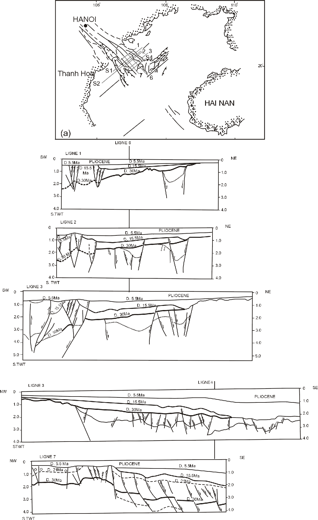
Rangin et al [16], and Phạm Năng Vũ [14] have proved that the offshore segments of the Red River fault system were active from Oligocene to Late Miocene. According to the published petroleum seismic profiles, crossing the strike of the Red River fault system, there clearly existed three regional unconformities. They divided the sedimentary layers into 4 sequences. The first unconformity has been dated as 30 Ma and coincides with the starting time of the East Việt Nam Sea (South China Sea) opening that caused the regression. The second has been dated as either 16.5 or 15.5 Ma and coincides with the cessation of the opening of the East Việt Nam Sea.
Figure 1: Location map (a) and interpretative seismic profiles evidencing the transpression at the SW and synchronous transtension at NE edge of the Sông Hồng Basin; the southeastward migration of depocenters as well as the major unconformities are of 30, 15.5, 5.5 Ma (after Rangin et al [16]).
The last has been dated as 5.5 Ma. Prior to 30 Ma, the vast area of the Bắc Bộ Gulf was subjected to NE-SW extension. After 30 Ma, the tectonic activities were restricted within a zone of 30 km wide between Vĩnh Ninh and Sông Chảy faults. Between 30 and 15.5 Ma, the tectonic activities were characterized by left-lateral extension regime. This type of tectonics displays well on the seismic profiles by the presence of the normal NW-SE to E-W strending faults. The southeastward migration of the depocenters during left-lateral displacement along the Red River Fault system was also evidenced by seismic data that crosses as well as runs parallelly with the fault zone. The sedimentary sequences accumulated during the extensional motion within the Red River Fault zone was covered unconformably by Pliocene sediments with an unconformity dated as 5.5 Ma. Between 15.5 and 5.5 Ma, the southwestern band of the Red River Fault system suffered from a tectonic inversion meanwhile in the northeastern band the extension continued to be developed. After the 5.5 Ma unconformity no tectonic activity was observed in petroleum seismic profiles. However, on the high resolution seismic profiles which were obtained in the shallow-water zone of the Red River delta indicated that the NE-SW extension was still active in Quaternary [2]. Thus, two Miocene unconformities separated the different periods of tectonic activities. Between 30 and 15.5 Ma unconformities, the tectonic activity was characterized by a component of NE-SW extension within the strike-slip motion (Fig. 1). This extension affected not only the Red River Fault, but also the Bù Khạng Dome that was located 200 km southwestward of the Red River Fault [6,12]. The dome was subjected to an extension displayed by the ductile detachment fault that was active from 30 to 20 Ma. Between 15.5 and 5.5 Ma, a narrow band of the Red River Fault zone was affected by NE-SW compression, meanwhile the rest of this zone continued to suffer an approximate N-S extension up to 5.5 Ma (Fig.1). The tectonic inversion appears to displace further and further to the southwestern part of the Red River Fault system in the one hand, and along its strike in the other hand.
These data evidence that the tectonic activities of the offshore segments of the Red River Fault zone were mainly controlled by the presence of two coeval tectonic regimes. The first one is the left-lateral extension, meanwhile the second is the left-lateral compression. The tectonic activities themselves have propagated from northeast to southwest and southward.
KINEMATIC MODELS OF THE FORMATION OF THE SÔNG HỒNG BASIN
Models proposed by previous works
There were different models that have been proposed in order to interpret the deformations that were well reserved on land along the Red River shear zone from the Xuelung Shan, Diancang Shan through Ailao Shan to Dãy Núi Con Voi ranges. All models linked these deformations with the Indo-Eurasian north-south convergent consequences. Among different proposed models for interpreting the ductile shear and opening of the Biển Đông Sea, the Tapponnier’s model is widely used as reference in many research works (Figure 2). According to this 2D model, the Indochina Block has been extruded southeastward when the great Indian plate penetrated into the Eurasian plate since 55 Ma ago. This model does not take into account the lithospheric thickening effects in the Himalaya and Tibet regions. Recently, Mattauer et al [11] have proposed another model in which the lithospheric thickening and intra-continentalsubduction has been included. However, the evolution of the sedimentary systems inside the Sông Hồng basin arose some unsolved questions: for example, how and why did the extension take place before the shear motion along the Red River shear zone? Why the Oligocene-Miocene metamorphic rocks could be juxtaposed with sedimentary rocks of the same age? Why did exist the alternation between the NE-SW extension and NE-SW compressive events inside the basin [16]? Why did the fault activity propagate southward? What was the relation between the Oligocene-Miocene NE-SW trending Bù Khạng detachment and the sinistral shear of Red River zone [6]?
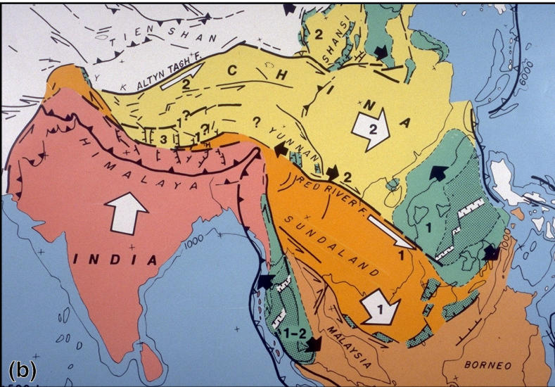
Figure 2. Tapponnier's kinematic model interpreting the Asian Cenozoic deformations [20]
New model and its implication
The above published data concerning the on land deformations and metamorphism as well as the offshore seismic data allow us to propose another model based on the Tapponnier’s one. In this model, we take into account qualitatively the shortening of the continental crust induced by the Indo-Eurasian collision and the clockwise rotation of Indochina block. This model differs from the previously proposed ones by the assumption that the Indochina block rotated around two poles corresponding to two stages of the opening of the East Việt Nam Sea as indicated roughly by N-S and NW-SE extension respectively.
Firstly, we assume that the trace of the Red River Fault at 30 Ma was located as indicated in Fig. 3. The line xy shows the displacement of the Indian plate since 30 Ma to present. As the Indian plate displaced northward, the material on its right side was dragged. The arrow 1 (in square box) is decomposed into two components. The first vector numbered as 2 is perpendicular to the trace of the Red River fault. This compression component induced the metamorphism and triggered off the northward move of the crustal materials. The second component numbered as 2 is parallel to the fault trace. This tangential component induced the material situated in the south of the fault trace to displace eastward and south-eastward. This motion corresponds to the left-lateral shear. In the plate tectonics scale, the Indochina block rotated along a small circle with a radius differing from the fault trace itself as the Briais’ idea [1]. Therefore the trajectory of the Indochina Block intersects the fault trace at a point called as N. This point corresponds to the strike - slip tectonic regime. It separates also the whole length of the fault zone into two parts having distinct tectonic regimes. The western part (grey area in the Fig. 3) of the fault trace was subjected to a left-lateral compression while the eastern part is subjected to a left-lateral extension. The area under transpression may be subjected to metamorphism and southeastward displacement. The area under transtension may be subjected to depression and sedimentary deposition.
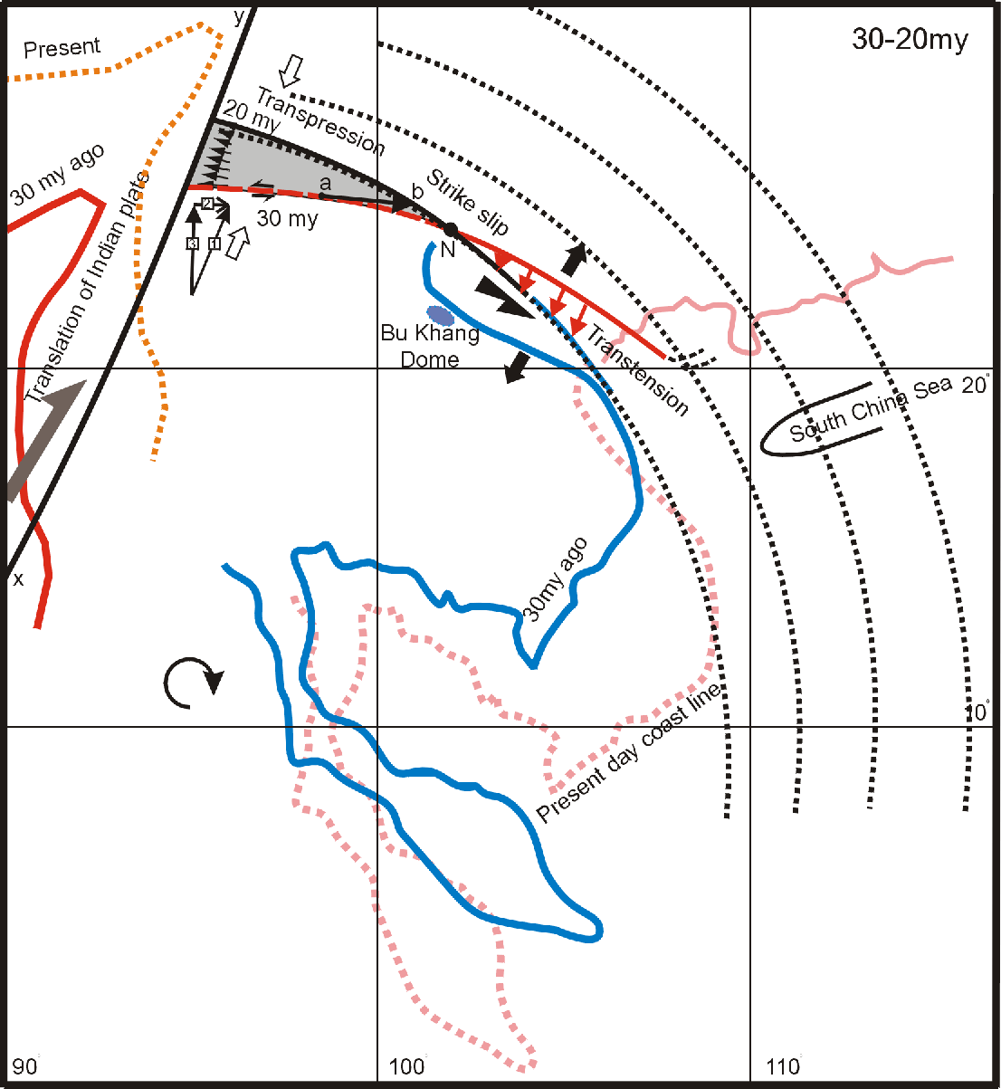
Figure 3. Configuration of the Red River Fault trace coupled with the trajectory of the Indochina Block between 30-20 Ma. The grey area suffers from compression to transpression represented by opened arrows. N is neutral point. The area located in SE of this point experienced a transtension represented by black arrows. Vector ab represents the synchronous exhumation of metamorphic rocks with the left-lateral movement. The dotted lines represent the move of the East Việt Nam Sea block in comparing with the fixed South China territory
When the Indian plate migrates northward, the fault trace tends to displace to the north with different amount along its strike (Fig. 3). This process tends to induce the small circle coinciding with the strike of the fault trace. In the following stage between 20-15 Ma, the Indochina Block rotates around a new small circle moving to another place with a radius differing from the curvature of the newly formed fault trace of the previous stage (Fig. 4). As the result, the trajectory of the Indochina Block intersects again the fault trace at a new point located farther to the southeast (Fig. 4).
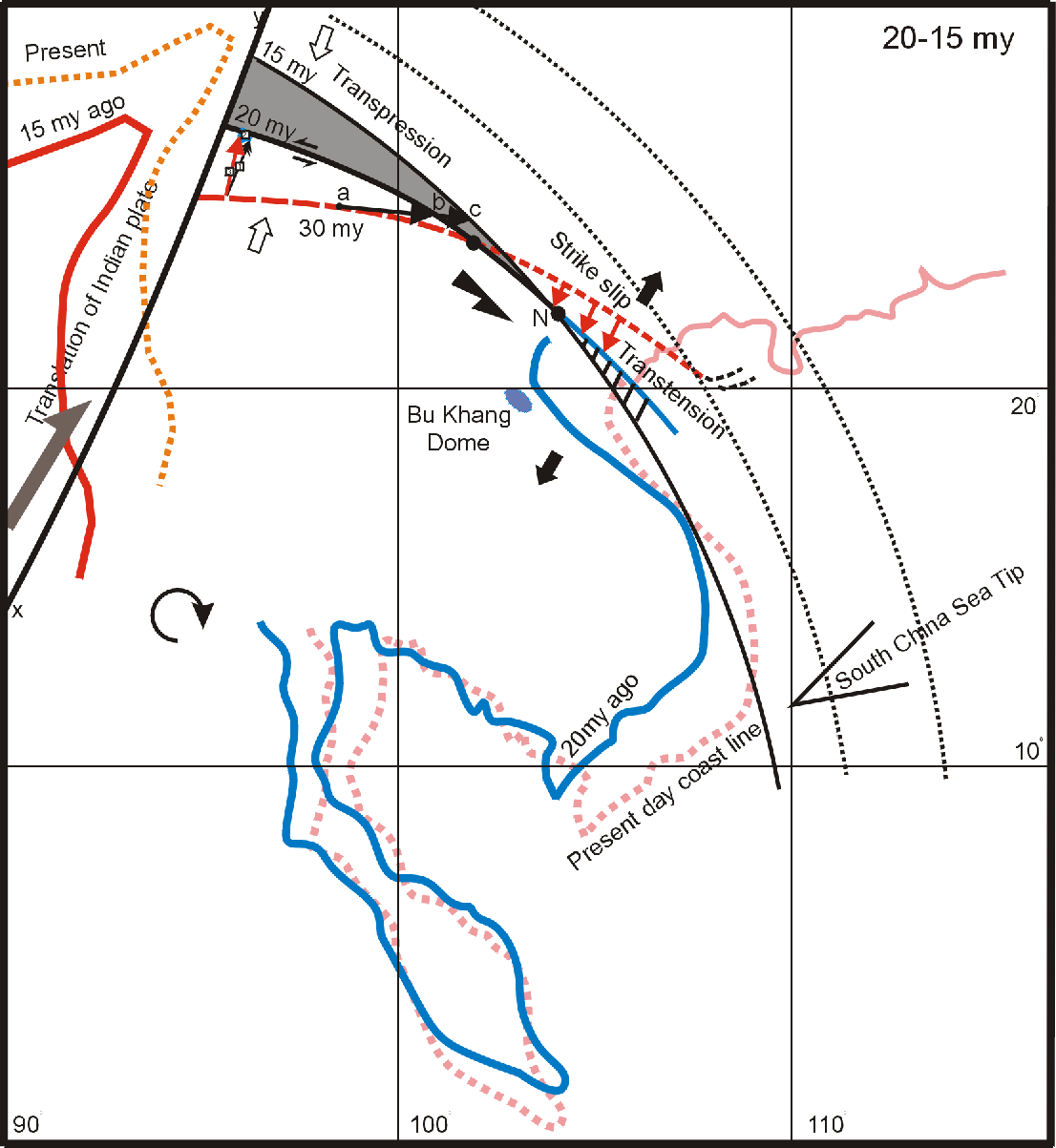
Figure 4. Configuration of the Red River Fault trace coupled with the trajectory of Indochina Block between 20-15 Ma. The newly formed extension, represented by hachured area and located in the southeast of point N, was added to the former extension represented by arrows. The point b now moved to point c
The same scenario could happen with an important difference. Due to the southeastward migration of the neutral point N in successive stages, a NE-SW compression that come into being in the later stage could replace the NE-SW extension that pre-exists in the former stage. This compression locally affected only the triangular area of the Sông Hồng basin (Fig. 5). In consequence of this compression, the tectonic inversion took place and induced the flower structures as seen in seismic profiles [16] meanwhile the area located in the southeast of the new neutral point was subjected continuously to the NE-SW extension.
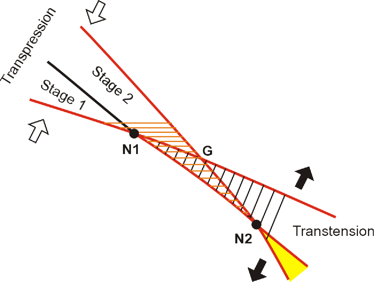
Figure 5. Interpretative scheme of the tectonic inversion at the southwern edge of the Sông Hồng Basin. The portion of the Red River Fault, wich suffered from a transtension, is represented by oblique lines. The area, that underwent a transpression, is represented by horizontal lines. The area limited by N1N2G triangle suffered from an extension in the stag 1 but compression in the stage 2.
Between 30 and 15 Ma, the tangential component of the fault trace reduced gradually its magnitude leading to the left-lateral shear which reduced also to zero when the vector 1 (in square box) (Fig. 3) became perpendicular to the fault trace. After 15 Ma, the vector 1 (Fig. 6) kept parallel to the Indian trajectory and now it is decomposed into two components. The vector 2 is tangential to the fault trace but oriented to NW, so that it causes the right-lateral slip while the vector 3 keeps its role as in previous stage. After 5.5 Ma, this inversion of movement predominated for the entire of the on land fault zone. Between 5.5 and 0 Ma, the Sông Hồng Basin continued to extend and to accumulate a sequence of undisturbed sedimentary deposition as proved by Rangin et al [16].
This model interprets the ductile extension observed in Bù Khạng as a consequence of the extensive tectonics that has affected the most part of the Indochina margin. The exhumation paths of the Oligocene-Miocene metamorphic rocks now exposed along the Red River shear zone are a 3D problem. This model displays only the path in 2D that represents by the line abcd from 30 to 5.5 Ma. Each segment represents a cooling history that differs from the others as evidenced by Leloup et al [9], Harrison et al [5] and Trần Ngọc Nam et al [23].
CONCLUSION
The kinematic model proposed in this paper allows to interpret some unexplained questions as mentioned above. Almost all tectonic structures observed within the Sông Hồng Basin could be explained by the present kinematic model. Furthermore, it could predict some consequences of the movement along the Red River Fault zone as the stress changes during the brittle deformations. However, this is a qualitative attempt, therefore it should be computed with the global kinematics. This problem is a difficulty due to the lack of data from the internal deformation of the Indochina Block, for example the amplitude of the ductile deformation in the Bù Khạng Dome as well as the brittle extension in the Sông Hồng Basin. Apart from this problem, the exact position of the neutral point N during the infinitesimal displacement of the left-lateral slip is unknown. The present day position of N is probably located somewhere in the transition between the compression and extension within the Red river Delta as suggestions by seismic profiles.
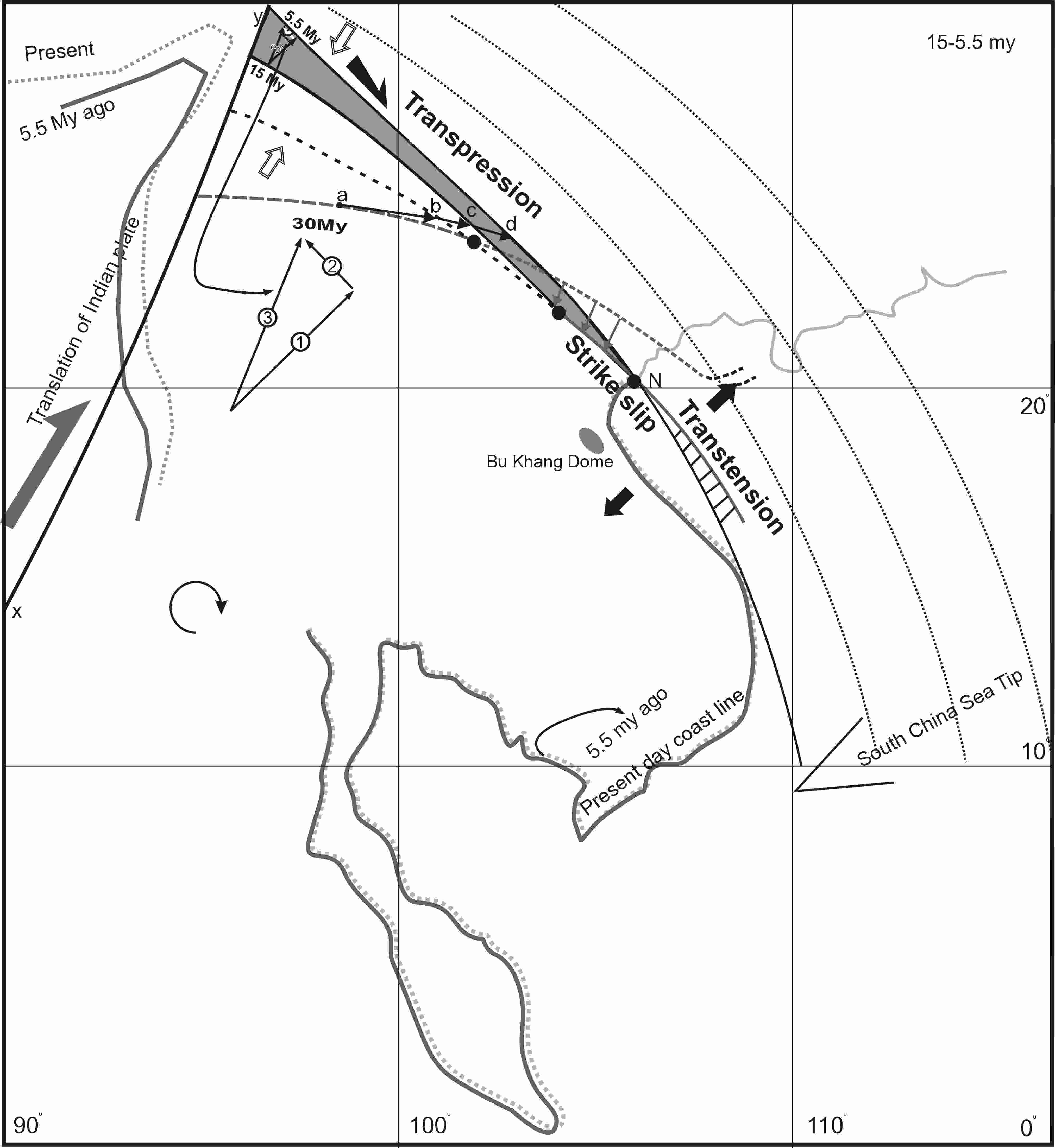
Figure 6. Configuration of the Red River Fault trace coupled with the trajectory of the Indochina Block between 15-5.5 Ma. The newly formed extension, that is represented by hachured area and located in the southeast of point N, is added to the former extension. The point c in previous stage now moved to point d and was exposed on the surface. The grey area represents the metamorphic ranges now exposed along the Red River Fault zone.
Acknowledgement
The authors of this paper would like to thank the Profs. Tống Dzuy Thanh, Trần Nghi, Đặng Trung Thuận, Phan Trường Thị and many colleagues of the Faculty of Geology, Hà Nội University of Natural Sciences for their encouragement and fruitful discussion. This is a contribution to the Programme of Basic Research in geology, geodynamics of the Red River Fault of Việt Nam.
REFERENCES
1. Briais A., Patriat P., Tapponnier P., 1993. Updated interpretation of magnetic anomalies and sea floor spreading stages in the South China Sea : Implication for the Tertiary tectonics of SE Asia. J. Geophys. Res., 98 : 6299-6328.
2. Chu Văn Ngợi, Trần nghi, Mai Trọng nhuận, Đặng Văn Luyến, Đỗ Minh Đức, 2000. Geodynamic characteristics of the Red River delta in Holocene. J. of Geology, Special issue Serie A: 40-45. Hà Nội (in Vietnamese with abstract in English).
3. Harder S., Mauri S. J., MC Cabe R., 1992. Miocene right lateral motion on the Red River fault and in the Song Hong - Yinggehai basin, Vietnam. Trans. Amer. Geophys. Union. EOS., 73 / 43 : 534-535.
4. Harrison T. M., Chen Wenji, P. H. Leloup, F. J. Ryerson, P. Tapponnier, 1992. An early Miocene transition in deformation regime within the Red River fault zone, Yunnan, and its significance for Indo-Asian tectonics. J. Geophys. Res., 97 : 7159- 7182.
5. Harrison T. M., P. H. Leloup, F. J. Ryerson, P. Tapponnier, R. Clacassin, Chen Wenji, 1996. Diachronous initiation of transtension along the Ailao Shan - Red River Shear zone, Yunnan and Vietnam. In The Tectonics of Asia, edited by An Yin, and T.M. Harrison, World and regional geology series : 208-226, Cambridge Univ. Press.
6. Jolivet L., Maluski H., Beysac O., Goffé B., Thị P.T., Vượng N. V., 1999. Oligocene-Miocene Bu Khang extensional gneiss dome in Viet Nam: Geodynamic implications. Geology, 27 : 67-70.
7. Leloup P. H., Kienast J. R., 1993. High temperature metamorphism in a major strike slip shear zone: the Ailao Shan - Red River (P.R.C). Earth Planet. Sci. Lett., 118 : 213-234.
8. Leloup P. H., Harrison T. M., Ryerson F. J., Chen Wenji, Li Qi, Tapponnier P., Lacassin R., 1993. Structural, petrological and thermal evolution of a Tertiary ductile strike-slip shear zone, Diancang Shan, Yunnan. J. Geophys. Res., 98 : 6715-6743.
9. Leloup P. H., Lacassin R., Tapponnier P., Sharer U., Zhong Dali., Liu Xiaohan., Zhang L., Ji S., Trịnh P. T., 1995. The Ailao Shan - Red River shear zone (Yunnan, China) : Tertiary transform boundary of Indochina. Tectonophysics, 251 : 3-84.
10. Leloup P. H., Arnaud N., Lacassin R., Kienast J. R., Harrison T. M., Phan Trọngj Trịnh, Replumaz A., Tapponnier P., 2001. New constraints on the structure, thermochronology and timing of the Ailao Shan - Red River shear zone, SE Asia. J. Geophys. Res, 106 : 6657-6671.
11. Mattauer M., Matte P., Olivet J. L., 1999. A 3D model of the India-Asia collision at plate scale. C. R. Acad. Sci., Sciences de la terre et des planètes. 328 : 499-508. Paris.
12. Nguyễn Văn Vượng, 1997. étude structural de la chaine de Truong Son (Vietnam Central): évolution tectonique d’une zone de cisaillement polyphasé. Université Pierre et Marie Curie. 288p.
13. Peltzer G., Tapponnier P., 1988. Formation and evolution of strike-slip faults, rift and basin during the India-Asia collision: an experimental approach. J. Geophys. Res., 93 : 15085-15117.
14. Phạm Năng Vũ, 2000. The Cenozoic deformation of the Red River fault zone. J. of Sciences of the Earth, 4 / 22: 278-289. Hà Nội (in Vietnamese with abstract in English)
15. Rangin C., Jolivet L., Pubelier M., And Tethys - Pacific Working Group, 1990. A simple model for the tectonic evolution of Southeast Asia and Indonesia region for the past 43 M.y. Bull. Soc. Geol. France, 6 : 889-905.
16. Rangin C, Klein M., Roque D., Le Pichon X., Lê Văn Trọng., 1995. The Red River fault system in the Tonkin Gulf, Vietnam. Tectonophysics, 243 : 209-222.
17. Shọrer U., Tapponnier P., Lacassin R., Leloup P. H., Zhong Dalai., Ji S., 1990. Intraplate tectonics in Asia: a precise age for large scale Miocene movement along the Ailao Shan - Red River shear zone, China. Earth Planet. Sci. Lett., 97 : 65-77.
18. Shọrer U., Lian Sheng Z., Tapponnier P., 1994. Duration of strike-slip movement on large shear zone: the Red River belt, China. Earth Planet. Sci. Lett., 126: 379-397.
19. Tạ Trọng Thắng, Vũ Văn Tích, Lê Văn Mạnh, Trần Ngọc Nam, Nguyễn Văn Vượng, 2000. On the deformation process and thermodynamic evolution of the Red River fault zone. Journal of Sciences of the earth. 22, 4 372-379.
20. Tapponnier P., Pelzer G., Ledain A. Y., Armijo R., Cobbold P., 1982. Propagating extrusion tectonics in Asia: new insights from simple experiments with plasticine. Geology, 10 : 611-616.
21. Tapponnier P., Lacassin R., Leloup P. H., Shọrer U., Zhong D., Ji S., Wu H., Zhong J., Zhang L., Liu X., 1990. The Ailao Shan/Red River metamorphic belt: Tertiary left-lateral shear between Indochina and South China. Nature, 343 : 431-437.
22. Tapponnier P., Peltzer G., Armijo R., 1986. On the mechanics of the collision between India and Asia. In: Collision Tectonics, edited by Coward M. P., and A. C. Ries, Geol. Soc. Spec. Publ., 19 : 115-157. Geol. Soc., London.
23. Trần Ngọc Nam, Toriumi M., Itaya T., 1998. P-T-t paths and post-metamorphic exhumation of the Day Nui Con Voi shear zone in Vietnam. Tectonophysics, 290 : 299-318.