HOLOCENE SEA-LEVEL CHANGES IN TRƯỜNG SA ARCHIPELAGO AREA
NGUYỄN
VĂN BÁCH, PHẠM VIỆT NGAInstitute of Oceanography, NCNST, Hoàng Quốc Việt, Cầu Giấy, Hà Nội
Abstract: The study on coral reefs in the Trường Sa Archipelago area reveals that Holocene sea-level changes are indicated by sequences of intercalated marine and terrestrial deposits. Relative slight transgression is represented here by marine sediment layers. The curve deduced from the study on sedimentary sequences shows that in the Trường Sa sea, Holocene sea-level had moved up and down 4 times in drop trend.
INTRODUCTION
In the Trường Sa Archipelago area, there are many coral reefs. On their top surface there are many reef islands and shallows. As known, coral reefs have been formed and growing in dependence upon stony coral colonies. In one's turn, stony coral colonies live and grow in response to sea-level changes. Thus, one can say the formation and development of coral reef indirectly depends upon sea-level. It means that, the coral reef is constructed and grows when the sea-level rises and is destroyed when it falls down. In other word, coral reef responds to the changes of sea-level. As world sea-level has changed in time, reef growth has not been continuous, but interrupted by series of glaciation and interglaciation. Reefs have been exposed and subjected to weathering and erosion during lowstand of sea-level caused by glaciation. And submerged with reefs re-establishing over their previously exposed surface during highstands of sea-level caused by interglaciation.
The study on sedimentary sequences of coral reef body provides information about sea-level changes. This paper presents the oscillations of Holocene sea-level in the Trường Sa sea. It is based on the sea-level indicator - sedimentary sequences from trial pits, which are digged in the confines of Trường Sa Island.
MATERIALS AND METHOD
In the confines of Trường Sa Island, there are some trial pits digged for geological survey and observation. In the vertical sections of those pits, one found pronounced stratigraphic sequence, composed of different sedimentary layers. The contact between them are distinct. Sediment samples were collected from these trial pits and studied by lithological methods in the field and analyzed by mineralogical and geochemical methods. The following data has been gathered: results of distinguishing various sedimentary units of a succession on the basis of single criteria such as colour, bedding characteristics, granulity parameters, shape and roundness of grains, degree of consolidation - level of lithification, fossils, surface texture of grains, chemical and mineralogical parameters, organic remains, etc. The study of physical factors combined with the study of biological and chemical factors provides with a more complete picture of sedimentary depositional environments. The careful study results of primary sedimentary structures, both inorganic and organic; the study results of facies including changes in horizontal direction as well as changes in vertical direction; the results of faunal and floral, palynological studies are used.
The above mentioned results help us to understand and interpret sedimentary depositional environments alternated in the vertical direction, that are caused by sea-level changes.
PREVIOUS WORKS
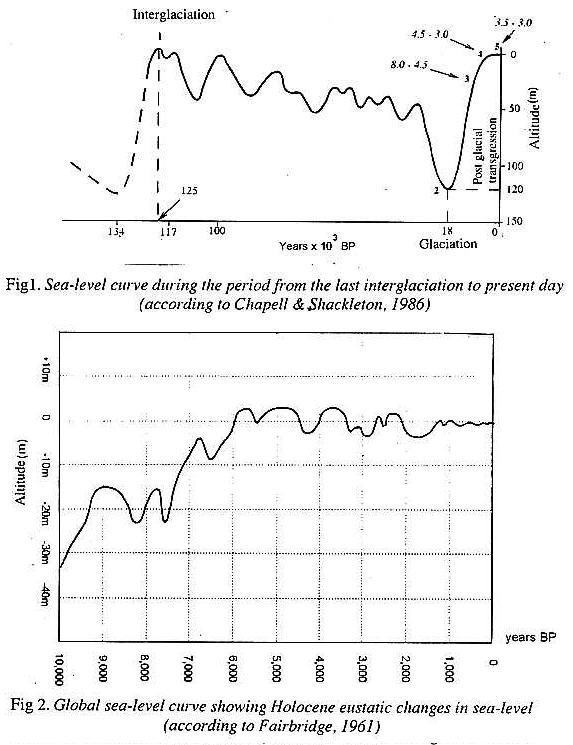
Many scientists are interested in the problem "Holocene sea-level changes", as during the historical period of mankind (especially the last 10,000 years) until quite recently. That's why, because the sea-level can be various recognized by low amplitude in the areas where sea-level was creating problems. While in the time before Holocene, sea-level had varied with a high amplitude and was recognized everywhere. And because the determination of Holocene sea-level changes provides with a basis for predicting coming sea-level changes, especially in densely populated low-lying coastal areas and islands. The sea-level has changed continuously from the last interglaciation to the last glaciation (Fig.1).
The first examples on Holocene sea-level curves are those reported from Sweden by Granlund (1932) and especially by Liden (1938), who studied on the sequences of Varve (sedimentary units according to the seasons). Godwin (1940) produced a curve of sea-level changes in the Finland dated by pollen analysis and archaeological data. Only since 1950's, with the in vent of radiocarbon dating, several significant Holocene sea-level studies were published. Fairbridge (1961) deduced a fluctuating sea-level pattern (Fig.2); Shepard (1963, 1964) suggested a gradually rising sea-level; and Fisk, 1956; Godwin et al, 1958; Mc Farlan 1961 suggested the occurrence of a continuously rising sea-level without important fluctuations from late glacial times until about 5,500 years BP, followed by sea-level stability. Several new sea-level curves were published in the 1960's; most of them differ from one another. The lack of mutual understanding was so great that UNESCO and the Internatioanl Union of Geological Sciences (IUGS) launched in 1974, in the framework of the International Geological Correlation Programme (IGCP), the Project 61 "Sea-level changes during the last hemicycle (c.15,000 years)" with the aim to determine by 1982 an eustatic curve which could reconcile various scientists.
Generally, one can see that these and other results helping to demonstrate the determination of single sea-level curve of global applicability are an illusory task and that, by definition of the initial goal of IGCP 61 is attached to obsolete theories derived from Strabo, though updated in part by Daly (1934) and Bloom (1967) was ill conceived [5]. With the succeeding IGCP Project 200 "Sea-level correlation and application" led by P. A. Pirazzoli from 1983 to 1987, the aim was to determine local sea-level history as precisely as possible to consider all such variations as potentially influenced by a complex of local, regional and global processes and to indentify and assess internal and external effects.
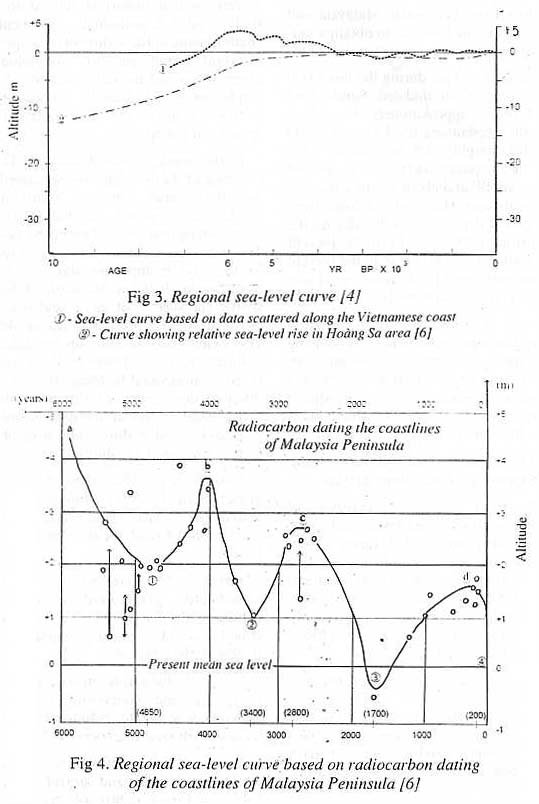
In concerning to Việt Nam and Việt Nam East Sea, Fontaine and Delibrias (1974) had proposed a "sea-level" curve 1 (Fig.3) using data scattered along the Vietnamese coast (which is over 2000km long, with spring/diurnal/tropical tidal range varying from 0.5 m to 3.5 m). There is evidence of sea-levels decreasing with age following a maximum at circa +4m with the age reaching about 6.000 years ago.
The fluctuating pattern of the curve 1, inspired by Fairbridge (1961) is however doubtful, while negative oscillations were not studied by Fontaine and Delibrias (1974) [4]. In the Hoàng Sa region (Paracel islands) Zhang (1987) did not find any indications of recent emergence and proposed a curve 2 (Fig.3) which shows a relative sea-level rise of no more than a dozen of metres since 10,000 BP, which seems very underestimated [4]. Tjia H.D. used 40 carbon-dated shoreline indicators from Peninsular Malaysia and few islands in the East Sea to obtain a sea-level curve (Fig.4).
According to Tjia, during the last 6,000 years, sea-level in undated Sunda land with 4 peaks, approximately 4 - 4.5 m above the present sea-level around 6,000 years BP, roughly 3.5 m around 4,000 years BP, approximately 2.5 m around 2,800 years BP and about 0.5 m some 200 or 80 years ago. The sea-level curve from the Figure 4 demonstrates that during the period from 6,000 years BP to the present time, sea-level was higher than the present one, but only circa 1,700 years ago it was lower than the present one [6].
In the Trường Sa region (Spratly islands) the paper authors have been using stratigraphic sequences of sedimentary units, according to different depositional sedimentary environments (subaquatic and subaerial) to find general fluctuations of the Holocene sea-level in this area.
SEA-LEVEL INDICATOR AND ANALYSIS, SYNTHESIS AND SUPPOSITION
The usual procedure consists of identifying former sea-level indicators, locating the position of a former water plane. Several sea-level indicators can be used. Among archaeological remains there are the most useful or obviously those implying specific activities and classes of people, who were closely related to the sea [5].
Some scientists have been using a sequence of varves as a very precise dating tool. Another have been producing a curve of sea-level changes by pollen analysis and archaeological data, radiocarbon dating and measuring. Measuring elevation is possible in relation to a referential level.
Our principal method used to identify former sea-level positions (sea-level moved up and down) is related to the study on depositional sedimentary environments in the sedimentary sequence of coral island and to morphological observations and the determination of the height of coral islands. Other study method includes the determination of spores and pollens.
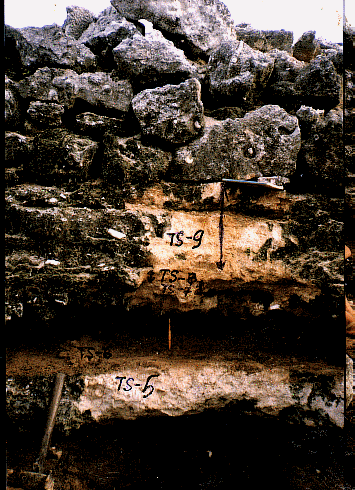
In this work, sea-level indicator is the presence of marine deposits, separated by terrestrial ones in a stratigraphic succession, exposed in the wall of northeastern trial pit in Trường Sa Island. This island is located within the Trường Sa (Spratly) archipelago and is not far from Sunda shelf (in the north of Sunda shelf). The surface of this island is at 3m or so above the present mean sea-level. The island body is built up by different sedimentary units, being in the form of layers of horizontal bedding (Fig.5). The lithology description of sedimentary units, which build up the stratigraphic sequence and can be used as direct indicators of sea level is presented as follows:
Layer 1: coffee-coloured organic matter of mud size containing roots and pollen-spores, guano and white coloured coral debris of sand-silt size; thickness 5 – 6 cm.
Layer 2: grey-white, slightly consolidated gravel-sand is of coral debris, with disordered and pumiceous structure and contains shell fauna; thickness: 50 – 60 cm.
Layer 3: brownish organic matter of mud size and containing guano and pollen-spores, white coloured debris of sand and silt size; thickness: 4- 5 cm.
Layer 4: grey-white, slightly consolidated sand and gravel of coral debris and reef debris of massive and pumiceous structure, with the grains moderately rounded, containing shell remains; thickness: 5 – 6 cm.
Layer 5: yellow-brownish organic matter of mud size; slightly consolidated, somewhere sticky and containing guano, pollen-spores; white coral debris of sand and silt size; thickness: 25 - 30cm.
Layer 6: grey-white, slightly consolidated gravel-sand of coral debris and reef debris with moderate roundness, massive and pumiceous structure, containing shell remains; thickness: 20 - 25cm.
Layer 7: yellow-brownish organic matter of mud size, slightly consolidated, containing guano, pollen-spores; white coral debris of sand-silt size; thickness: 18 - 20cm.
Layer 8: white, moderately consolidated gravel-sand of coral debris and reef debris with poor and moderate roundness, massive structure containing shell remains; thickness: 25 – 30 cm.
|
|
Layer 1
Layer 2 Layer 3 Layer 4 Layer 5
Layer 6
Layer 7
Layer 6
Layer 7 Layer 7
Unit 7 |
|
||
|
|
Layer 8 |
|
||
|
|
Layer 9 |
|
||
Fig.5: A sequence of intercalated marine and terrestrial deposits
in the wall of trial pit [4]
All these layers are of Holocene age.
The layers 2, 4, 6, 8 consist of gravel-sandy sediments, which are composed of white coloured coral debris-fragments and reef debris, poorly sorted, slightly consolidated with massive, pumiceous structure and containing shell remains without pollen-spores. The above sedimentary characteristics show that they were accumulated in subaqueous lagoon environment [2].
Layers 1, 3, 5 and 7 consist of sand-silty sediments of white coloured coral debris and brownish organic matter containing phosphorite (guano) and pollen-spores (Table 1). These sand-silts are moderately sorted. Here, it is necessary to emphasize that guano being in sand-silty layer is the result of bird vital activity [2]. Sedimentary features of sand silty layer show that sediments of these layers were accumulated in subaerial environment (surfacial conditions).
Table 1. List of pollens and spores
|
Layers (downward) |
Pollens and spores |
|
Layer 1: Coffee-coloured organic matter of mud size. |
Taxodium sp. |
|
Layer 2: Grey-white gravel sand. |
(Absence) |
|
Layer 3: Brownish organic matter of mud size. |
. Dicksonia sp. . Gleichenia sp. . Taxodium sp. . Larix sp. |
|
Layer 4: Grey-white sand-gravel. |
(Absence) |
|
Layer 5: Yellow-brownish organic matter of mud size. |
. Sequoia sp. . Taxodium sp. |
|
Layer 6: Grey-white gravel-sand. |
(Absence) |
|
Layer 7: Yellow-brownish organic matter of mud size. |
. Sphagnum sp. . Larix sp. |
|
Layer 8: White gravel-sand. |
(Absence) |
Thus, the sedimentary layers in the observed stratigraphic sequence consist of terrestrial and marine deposits. They are formed in depositional environments caused by the sea-level oscillations (up and down). Consequently, the sedimentary basin where the study deposits are formed was emerged and submerged. sea-level highstands occurred during forming processes of layers 8, 6, 4 and 2; and sea-level lowstands - 7, 5, 3 and 1.
The study results of depositional environments provide with informations to reconstruct the sea-level positions in the last 6,000 years. Here, it must be admitted that in the time of 6,000 years or so before present in Trường Sa region, the sea-level was higher than the present by 5 - 6m. That's why several coral reefs have the top surfaces of 5m in height. Nowadays, the most of scientific works touching upon Holocene sea-level changes support the conclusion that the sea-level was at +5m dated 6,000 years BP [1, 6]. Thus, in Trường Sa Sea for the last 6,000 years BP sea-level has moved up and down 4 times (Fig.6) in a drop trend. The curve in Fig.6 is deduced from the study results of sedimentary sequence and stratigraphic, pollen-spores, chemical analysis and sedimentary basin analysis.
The curve from Fig.6 presents following remarks on Holocene sea-level oscillations via the origin of sedimentary deposits:
1. Marine deposits are mostly of sand-gravel sediments. They were weathered during the Holocene regression and overlain by sand-silty terrestrial sediments.
2. Terrestrial deposits are mostly of sand-silty sediments. They were abraded by sea currents during the Holocene transgression and overlain by sand-gravel marine sediments.
3. The overlap of terrestrial facies over marine facies indicates the beginning of regressive tendencies in the studied region development.

4. The overlap of marine facies over terrestrial facies indicates the beginning of transgressive tendencies in the studied region development.
CONCLUDING REMARKS
In the last 6,000 years, sea-level in Trường Sa Archipelago area has oscillated, moved up and down 4 times. The Trường Sa landform was submerged and emerged 4 times. Today this landform is being emerged. The study results of origofacies of sedimentary deposits provide with helpful informations to understand the oscillations of sea-level during the last 6,000 years in the Trường Sa area and are useful for a comparison with adjacent regions. The Holocene sea-level changes in Trường Sa area rather coincide with those on Sunda shelf, as sea-level history has varied greatly from place to place. The study of sea-level changes has fascinated generations of geologists, geophysicists and oceanographers. The changes, which occurred during the Holocene (last 10,000 years), have also important significance for prehistorians, archaeologists, historians, and paleoecologists and geographers [5].
This work is supported by the Fundamental Research Programme.
REFERENCES
1. Geyh M.A. et al., 1979. Sea level changes during the late Pleistocene and Holocene in the Triad of Malacca. Nature 278.
2. Nguyễn Văn Bách et al., 1998. Sea-level changes and formation of coral islands in Việt Nam sea. PetroVietnam Review, 3/1998. Hà Nội.
3. Nguyễn Văn Bách et al., 1998. Formation mechanism of Trường Sa island. PetroVietnam Review, 4/1998. Hà Nội.
4. Nguyễn Văn Nhân, 1993. The pit log on Trường Sa island. Hanoi Institute of Oceanography, Hanoi.
5. Pirazzoli P. A., 1991. World Atlas of Holocene sea-level changes. Elsevier, London.
6. Tjia H.D., 1980. The Sunda shelf, Southeast Asia. Zeitschrift Fỹr Geomorphologie N.F. Berlin Stuttgart.
Date of reception: 07 – 09 - 2001