I. INTRODUCTION
The
gravitational value is the total influence of many material masses with
difference density. This density is necessary and important for calculation of
terrain correction, Bouguer correction, and intermediary layer correction. The
intermediary layer is the layer of rock from observation point to geoid
surface. The determination of the average density value of intermediary layer
is a necessary problem for gravitational survey. We can use the average density
value of intermediary layer of the world (2.67 g/cm3) if the area of
gravitational survey is in mountain and 2.30 g/cm3 if the survey
area is deltaic area, where the layer is composed of Neogene and Quaternary
sediments. The gravitational data of Việt
According
to the definition of in force technical norms of gravitational prospecting,
when carrying out gravitational survey in large scale, there is the requirement
of absolute necessity to determine specific characteristics of density value of
intermediary rock layer in the survey area. Therefore, the determination of
specific characteristics of density value of intermediary layer is realized. By
methods of Netleton graphics, gravitational point Lucapchenco, to solve the
minimum standard deviation of equation system, and geologo-geophysical method,
the authors determine the average density value of the
II. THEORETICAL BASES AND CALCULATION METHOD
1. Theoretical bases
The
intermediary layer is the matter layer lying between observed point and geoid
surface. The average density value of this layer is called as specific
characteristic density value of intermediary layer or intermediary layer
density.
The
use of cylindrical coordinate system r, j, coordinate origin set in observed point A
(Fig. 1), vertical component Dg of gravity force in point A, far from plan layer
attract a distance H1 is calculated by formula:
![]() (1)
(1)
To
integrate above formula, obtained:
Dg(A) = 2Õ Gs [(H + H1) – H1]
= 2ÕGs.H (2)
It
is shown that, the vertical component of gravity force does not depend on
distance H1 but only depends on the layer thickness. Replacing the
values into formula (2), we obtain:
Dg(A) = 0.04192s (mGal) (3)
Where:
H - height of observation (m); s - density of intermediary layer (g/cm3).
In
general, the intermediary layer density is not constant, but varies in vertical
and horizontal directions. If the intermediary layer density changes in
vertical direction, the calculation is carried out to determine by model of horizontal
layers, which have densities s1, s2, s3 …sn, and the effect is
calculated by the formula:
Dg(A) = 0.0419
(s1H1 + s2H2 + … snHn) (4)
2. Calculating methods
a. Method of Netleton
graphics: Selecting a transversal
profile across studied area, where the topography is characteristic; carrying
out the measurement of gravitational value in this profile. Calculating the
Bouguer anomaly with different intermediary layer densities by formula:
DgB = gqs
- g0 + (0.3086 – 0.0419s) H (5)
Where:
DgB - Bouguer
anomaly (mGal); gqs - gravitational observation value (mGal); g0 - normal gravitational
value (mGal); H - height of gravitational observation point (m).
for
creating the Bouguer anomaly graphics of profile by all used intermediary layer
densities. The specified intermediary layer characteristic density is the
density of the curve DgB, which has the correlation with
topographical section is least. The method is simple and easy to be used, the
calculation is carried out fast on personal computer.
b. Method of Lucaptrenco
gravitational point: The determination of
intermediary layer characteristic density is based on the observed
gravitational value on area, where the terrain is abrupt or the slope angle of
topography is considerable. Selecting the profile to research, carrying out the
measurement of the gravitation in two points, one on the lowest area of the
mountain; one on the mountain summit, the Bouguer anomaly is calculated by
formulae:
For
No 1 point:
DgB1 = gqs1
- g01 + (0.3086 - 0.0419s). H1 (6)
For
No 2 point:
DgB2 = gqs2
- g02 + (0.3086 – 0.0419s). H2 (7)
The
intermediary layer density value is calculated by formula:
![]() (8)
(8)
Where:
DgB1,
DgB2
- Bouguer anomaly in points No 1 and 2; H1, H2
- heights of point No 1 and 2; gqs1, gqs2
- observed gravitational values; g01, g02 - normal gravitational
value.
The
method is simple and easy to be used, the result is confident.
c. Method of solving
equation system: The Bouguer anomaly is
represented by an equation system of different degrees.
In
an observed point, the Bouguer anomaly value is represented by the formula:
DgBi=gqs(xi)
- go(xi) +0.3086
h (xi) -0.0419s. h (xi)+Dgpi =
Dgf(xi)-0.0419.s.h(xi)+Dgpi=![]() (9)
(9)
If
x = 0 and ignoring the terrain correction, we obtain:
![]() (10)
(10)
Sets ao = DgF(0) – bh(0)
, we obtain:
![]() (11)
(11)
To
simplify, we make sign:
DgFi = DgF (xi) - DgF(o) (12)
Dhi = h (
xi) – h(o) (13)
The
formula is represented in the following form:
![]() (14)
(14)
According
to minimum square method, b needs to satisfy the requirement:
![]() (15)
(15)
Where
N: number of observation on profile; m: number of equation.
To
carry out derivative of above formula after am and b we obtain new
equation system. For solving this equation system to look for b value and s (g/cm3) to be
calculated.
If
the Bouguer anomaly in observed profile varies by linear function, DgBi = aix
from (15) we obtain the equation system:
![]() (16)
(16)
![]() (17)
(17)
If
the Bouguer anomaly varies by exponentional function, the formula has the form:
Dgbi = a1x + a2x2 (18)
![]() We have the following
equation system:
We have the following
equation system:
![]() (19)
(19)
![]() (20)
(20)
![]() (21)
(21)
Basing
on the observed data on profiles, we create one from two equation systems, to
solve to look for b.
From
b = 0.0419 s, looks for s.
d. Geologo-geophysical
method: The gravitational profile is on the geological section profile.
The
average density of intermediary layer is the arithmetical mean density by
section area of all geological formations that are present in the geological
section, calculated by the formula:
 (g/cm3) (22)
Survey
area after geological map or geological schema.
The
average density of intermediary layer is the arithmetic mean density by volume
of all geological formations that are present in the survey area, calculated by
the formula:
 (g/cm3) (23)
where
Si: area of numbered geological formation i (23 & 24); si: average density of
numbered geological formation i; N: number of geological formation; Vi:
volume of numbered geological formation i; Vi = Si x Hi
(25); Hi: height of gravitational observation point Si.
III. OBTAINED
RESULTS
1. Graphical Netleton method
By
the graphical Netleton method, carried out to calculate 766 points on 79
profiles, consisting of Hà Tiên 6, Southern delta 10, Northern delta 12, Kon
Tum 11, Ba Tơ 10, Đà Lạt 6, Quảng Ngãi 6, Nông Sơn 7, Cẩm Thủy 5, Cao Bằng 6.
The gravitational Bouguer anomaly on profiles has been calculated with density:
s1 = 2.00, s2 = 2.10, s3 = 2.20, s4 = 2.30, s5 = 2.40, s6 = 2.50, s7 = 2.60, s8 = 2.70, s9 = 2.80, s10 = 2.90 và s11 = 3.00 (g/cm3).
The
obtained results carried out to analyze statistic by probability method show
that: intermediary layer density value of 2.0 g/cm3 is
characteristic for Southern and Northern delta regions. Intermediary layer
density 2.0 - 2.60 g/cm3 is characteristic for mountain regions such
as Kon Tum, Quảng Ngãi, Nông Sơn, Đà Lạt, Cẩm Thủy, Cao Bằng, ....
2. Gravitational Lucaptrenco point method
After
this method, it is necessary to determine gravitational anomaly difference (Dg = gqs - g0) between two observed
points (gqs1, gqs2), and their heights (H1, H2)
far from geoid surface, where the first point (gqs1) is located near
the second point (gqs2). The second observed point is called as
standard basis of survey area. This point always is put on the mountain summit,
where the height is greatest (Phan Si Pan, Bạch Mã, Ngọc Linh …). 21 points
from the 26 points of standard bases (gqs2) have the height from 500
to 1600 m. The calculation has been carried out for 1295 points distributed
over the whole of our country. The intermediary layer density value obtains by
the formula:
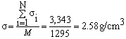
Where
s:
intermediary layer density value for the whole country; si: the intermediary layer
density value of numbered point I; M: number to calculate.
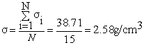
3. Equation system solving method
To
compile the equation system for calculation on 15 gravitational profiles distributed
over the whole country. The calculation is performed by personal computer. The
result is intermediary layer density value of every profile. The intermediary
layer density value is arithmetical mean density value. The intermediary layer
density value of every profile is as follows:
1.
Profile Rạch Giá - Long Xuyên: 2.35 g/cm3; 2. Profile Long Xuyên -
Châu Đốc: 2.38 g/cm3; 3. Profile HồChíMinh City - Bảo Lộc: 2.58 g/cm3; 4. Profile Phan
Rang - Đà Lạt : 2.67 g/cm3;
5. Profile A Sầu - A Lưới : 2.56 g/cm3;
6. Profile Đông Hà - Bạch Mã: 2.65 g/cm3; 7. Profile Kon Tum - Khâm
Đức: 2.58 g/cm3; 8. Profile Hồ Xá - Bến Hải: 2.58 g/cm3;
9. Profile Phú Nhơn - Krông Búk: 2.56 g/cm3; 10. Profile Mộc Châu -
Mường Hét: 2.58 g/cm3; 11. Profile Tuần Giáo - Tây Trang: 2.62 g/cm3;
12. Profile Bắc Ninh - Lạng Sơn: 2.67 g/cm3; 13. Profile Phú Lộc -
Nguyên Bình: 2.58 g/cm3; 14. Profile Trà Bồng - Phước Sơn: 2.66 g/cm3;
15. Profile Nguyên Bình - Bảo Lộc: 2.69 g/cm3.
4. Geologo-geophysical method
a. By geological sections: The
calculation is performed on 19 sections of 6 geological structural regions,
consisting of: Northwest Việt Nam region - 1 section; Northeast Việt Nam region
- 1 section; North of Central Việt Nam - 1 section; Huế - Quảng Ngãi region - 5
sections; Kon Tum - Buôn Ma Thuột - 2 sections; Đồng Nai - Bến Khế and South
Việt Nam - 6 sections. After the processing of method: - Determining the area
of every geological formation on the section; -
Density value sI of every
geological
formation is specified after gravitational survey projects [5, 6] and
synthesized from physical property of rock bed [8]; - The intermediary layer
density value is determined on every section, after that the arithmetical mean
for every region is calculated; at last the arithmetical mean for the whole
country is calculated.
b. By geological map area: To
divide the country into cell base areas, which have longitude (l) of 0030’00”
and latitude (j) of 0020’00”, made symbol (made code) longitude.latitude.cell name (for example: 0730.1820.01 or
0700.1800.01, studied cell is 01 at position 107030’ or 107000’
E and 18020’ or 18000’ N.
For
every cell base area we execute:
-
To compile geological section according to request perpendicular or nearly
perpendicular to the direction of geological formation; to go through or
asymptote nearly the geological works, geological observation point, to go
through the whole or nearly the whole geological formation.
-
To compile the synthetical stratigraphic column for every cell base area.
-
To assign the average density value to correlative geological formation
presented in cell base area. Density of geological formation to be used is the
value from gravitational survey project [5, 6] and physical property book of
rock [8]. After results, the density value can be divided into two
characteristic groups, as follows:
- The average density value of intermediary layer is characteristic with
value 2.30 g/cm3 for bigger than 115,000 km2 in delta
region. In there, the area of Red River delta region is about 15,000 km2 including
the provinces Thái Bình, Nam Định, Hải Dương, Hưng Yên, Hà Nội, Hà Nam and a
part of provinces Ninh Bình, Hải Phòng, Quảng Ninh, Bắc Ninh and Hà Tây. The
area of Mekong River delta is about 100,000 km2 including the
provinces Cà Mau, Kiên Giang, An Giang, Bạc Liêu, Sóc Trang, Cần Thơ, Đồng
Tháp, Vĩnh Long, Trà Vinh, Bến Tre, Tiền Giang, Long An, Tây Ninh, HồChíMinh
City, Bà Rịa - Vũng Tàu, Đồng Nai, Bình Dương, Bình Phước.
-
The average density value of intermediary layer is characteristic with value of
2.58 g/cm3 for about 215,000 km2 in mountainous region.
In there, there are provinces Bình Thuận, Ninh Thuận, Lâm Đồng, Đăk Lắc, Khánh
Hòa, Phú Yên, Gia Lai, Bình Định, Quảng Ngãi, Kon Tum, Quảng Nam, Đà Nẵng, Thừa
Thiên Huế, Quảng Trị, Quảng Bình, Hà Tĩnh, Nghệ An, Thanh Hóa, Thái Nguyên, Hòa
Bình, Phú Thọ, Sơn La, Lai Châu, Yên Bái, Lào Cai, Hà Giang, Tuyên Quang, Vĩnh
Phúc, Bắc Cạn, Cao Bằng; in the rest area of the provinces of Red River delta,
the density value is characteristic with the value of 2.30 g/cm3.
IV. CONCLUSIONS
The
density value of rocks and minerals existing in gravitational survey area is
necessary data not only for compiling survey projects, but also for determining
intermediary layer correction, terrain correction, compiling Bouguer anomaly
map and for quantity analysis of gravitational anomaly related to geological
and mineral researching projects. On the world, there are many methods for
determining intermediary layer density. Under the present conditions of Việt
-
Mean density of intermediary layer of 2.30 g/cm3, is characteristic
for the Mekong River Delta and the Red River Delta regions.
-
Mean density of intermediary layer of 2.58 g/cm3 is characteristic
for the mountainous regions, the rest mountain land country.
Like
this, one may use the intermediary layer density value of 2.58 g/cm3
for gravitational survey on hilly and mountainous region of Việt
REFERENCES
1. Cao Đình Triều, 2000.
Gravity and gravitational survey method. Sci.
& Techn. Publ. House, Hà Nội.
2.
3. Dept of Geology, 1978.
Regulations on technical gravitational survey method. Hà Nội.
4. Lê Minh, 2003. Compiling the
gravitational database of the whole world, establishing high accurate geoid
model on the
5. Lê Thanh Hải et al., 1991-2003. Report
on gravitational survey for compiling geological maps and mineral resource
investigation at 1:50,000 - 1:100,000 scales of regions: Hòa Bình - Cẩm Thủy
(1991); Bắc Giang (1993); Phan Thiết (1995); Mang Xim (1996); Điện Biên - Lai
Châu (1997); Sông Mã - Sơn La (1998); Cao Bằng - Đông Khê (2000); Ba Tơ (2001)
(Lê Thanh Hải);Đăk Tô (1996); East Kon Tum (1998) (Quách
Kim Chu); Rào Nậy - Hoành Sơn (1995); Quảng Ngãi (1997) (Nguyễn
Trọng Hiệp); Hưng Hóa (1994); Huế (1995); Tương Dương (1996); Lục Yên
Châu (2005) (Nguyễn Duy Tiêu); Quỳ Hợp (1991); Nông Sơn (1993);
Hà Tiên (1996) (Nguyễn Tài Thinh); Yên Châu (2003) (Chu
Quốc Khánh). Arch. of Div. of
Geophysics. Hà Nội.
6. Lê Thanh Hải et al, 2006. Report
of Scientific Project “Study on determination and evaluation of level effect of
factors influencing the highly accurate gravitational measure and method to
reduce”. Min. of Natur. Res. & Env..
Hà Nội.
7. Lê Thanh Hải, Nguyễn Xuân Sơn, 2000; Phạm Tiến
Thuận, 2003; Quách Văn Thục, 2006. Gravitational part of reports
on magnetic, spectral aeronautical survey at 1:50,000 scale and gravitational
survey at 1:100,000 scale of regions: Kon Tum (2000); North Đà Lạt (2003); Phan
Rang - Nha Trang (2006). Arch. Div. of
Geophysics. Hà Nội.
8. Nguyễn Hữu Trí, Đinh Đức Chất et al., 1998. Book
to refer to physical characteristics of rocks and some ores in Việt
9. Nguyễn Thiện Giao, Lê Thanh Hải et al., 1985. Report
on compiling and preparing to publish the gravitational map of Việt