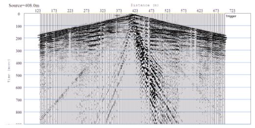
Figure 1. Walkaway
noise test data in Điện Biên area.
GEOLOGICAL STRUCTURE AND TECTONIC ACTIVITIES
IN ĐIỆN BIÊN CITY AREA BASED ON THE SHALLOW HIGH RESOLUTION SEISMIC SURVEY
1PHẠM NĂNG VŨ, 2NGUYỄN
DUY BÌNH, 2TĂNG ĐÌNH
1 Việt Nam Association of
Geophysicists, 18 Hoàng Quốc Việt, Hà Nội;
2Institute of Geosciences and Mineral Resources
(VIGMR), Thanh Xuân, Hà Nội.
Abstract: This paper introduces the results of the shallow
high resolution seismic reflection, which has been carried out in Việt
The seismic profile with length of approximately 1500 m was located at
the south of Điện Biên airport. The seismic reflection data acquisition was conducted
by common depth point method. The seismograph STRATAVISOR 48-channels made by
US Geometrics has been used for data gathering during survey. The field layout
consists of 141 m spread length and the observed fold data was 600 %. Raw data
was processed by Winseis Turbo 1.5 and interpreted by stratigraph seismic
methods.
The surveyed results allow to determine the detailed geological section,
rock facies and Quaternary sediment forming processes. In addition, the present
tectonic activities in Điện Biên city area were also highlighted. The data has
revealed and confirmed the signals of present tectonic activities in the Điện
Biên city area. However, based on the surveyed seismic data, it is supposed
that the magnitude of the earthquake in Điện Biên city area in the past is
rarely higher than 6 Richter degree.
I. INTRODUCTION
Northwest Việt
Recently, there were
numbers of studies on geological structure, recent tectonic activities and
earthquake predictions in the Northwest Việt
In order to have more
quantity of assessment on geological structure and neotectonic activities,
supplying for earthquake prediction and risk evaluation in Điện Biên city and
its surrounding area, in 2007, in the scope
of studies at ministerial level and targeted study at national level code
7.154.06, the authors wished to use shallow high resolution seismic reflection
method that effectively use for fault zones studies in the US, Europe and Asia
[1, 3], to examine the geological structure and tectonic activities in Điện
Biên city.
This article introduces the
results of shallow high resolution seismic reflection data for studying on
geological section and recent tectonic activities in Điện Biên area.
II. GEOLOGICAL SETTING
The seismic investigation
has been carried out in one line lasted 1500 m, cutting across the Điện Biên
trough, about 500 m south of Điện Biên Airport.
Geologically, the Điện Biên
trough is a young depression, developed along the longitudinal direction with
the length of about 20 km and 6-7 km in width. According to the available
seismic data, the Điện Biên trough has been restricted by Điện Biên - Lai Châu
fault and filled by clay, sand, pebble, cobble and debris, which originated
from mixed sources of alluvium, proluvium and diluvium, at the time of Middle
Pleistocene, Holocene and present. The drilling results reveal the thickness of
the Quaternary layer of 150-180 m. The basement below the Quaternary is
composed of basalt (N2-Q1), terrigeno-carbonate rocks (S2-D1
hn), clay shale and coal-bearing beds (T3n-r sb).
III. FIELD PROCEDURES
Seismic reflection data
were recorded using a standard CMP (common midpoint) acquisition method or
Common depth point seismic reflection method. Data were acquired using a
24-bit, 48-channel seismograph and 50 gramme of explosive in 3 m deep hole as
the seismic energy source. The selection of the optimum data acquisition
geometry receivers and recording parameters was made in the field after
extensive testing and analysis of the walk-away noise test data (Fig. 1). The
source-to-receiver offsets were chosen considering a compromise between
maximizing the range of offsets to improve velocity analysis and maximizing
spatial-sampling of shallow reflections which improve reflector coherency.
Based on the walkaway data
and the dynamic range of the recording instrument, the source-receiver geometry
was offset-spread with a source-to-nearest receiver spacing of 24 m. The
recording parameters included an analog filter-out and a sampling interval of
0.125 m/sec. The receiver spacing and source spacing were 3 m and 24 m,
respectively that allowed a fold of 600 %.
Identification of various
unique arrivals on the walkaway data allowed for confident selection of
parameters and geometries used for the CDP portion of the survey.
IV. DATA PROCESSING
The seismic data were
processed using the software package Winseis turbo 1.5. This commercial
software is popular worldwide and has proved effective for high resolution
shallow seismic data processing. The advantage of this software is easy to
install on PC. In addition, the software has simple interface, fast calculation
and good noise filter capacity and high quality output data.
The processed routine consists of:
- Formatting from SEG2 to KGSEGY;
- Preliminary editing;
- First arrival muting (direct wave and refraction);
- Surgical muting (removal of groundroll based on trace-by-trace arrival);
- Assigning geometries (input source and receiver locations);
- Elevation correction to multiple, floating datums;
- Sorting into CDPs (re-order traces in common midpoints);
- Velocity analysis (CVS);
- NMO correction;
- Digital filtering;
- Secondary editing (manual review and removal of bad or noisy traces);
- CDP stack;
- Amplitude normalizing;
- Correcting to flat datum;
- Displaying (printing).
Figure 1. Walkaway
noise test data in Điện Biên area.
V. INTERPRETATION
The seismic section
reflects the deep geological structure in the form of seismic wave fields,
which are observed on the ground surface. In order to master the deep
geological structure, it needs to interpret the geology of the seismic
sections. Commonly, the stratum seismic method, first proposed by Vail and
Mitchum (1874) at EXXOM Company, American was applied. The principe is very
simple, first the seismic section is analyzed based on the layered stratum
model and then divides the seismic section into seismic layers. These layers
distinguish with the lower and upper ones by the wave characteristics and
restricted at the top and bottom by stratum boundaries.
Nowadays, in the field of
stratum seismic, there is a routine to analyze the seismic sections as follows:
Step 1: Dividing the seismic section in vertical
orientation into seismic layers. Geologically, the seismic layers consist of
the same or related original sedimentation layers, which limited by the R3
unconformable boundary. Thus, it is possible considered a seismic layer as a
geological stratum layer.
Step 2: Determining the stratum seismic boundaries bases
upon the signals on bedding orientation and the reflected surface, which is
located at the top and bottom of the geological stratum layers. The signals for
determining the stratum boundaries are toplap, truncation, .... In order to
determine the R3 unconformable boundary at the bottom of the layer, it is
possible to use signals of downlap, onlap, etc. .
Step 3: Determining the facies of the seismic layers. This
determination is not based on the characteristics of the wave field, but on the
form, bedding of the reflected surfaces, frequency, amplitude of reflected
waves. The above characteristics are closely related to the fluctuation of the
ocean level.
Step 4: Determining the tectonic faults based on the below
signals:
- There exists a systematic
movement in vertical direction of the reflected surfaces in both sides of the
fault;
- There exist waveless
zones.
- The waves reflect from
the shear surface of the fault with the gentle slope fault.
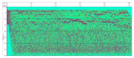
Figure 2. CDP stack section
along the surveyed line
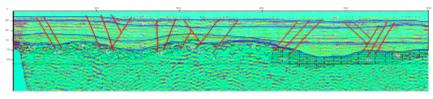
Figure 3. CDP stack section with
interpretation
The analyzed results of the
seismic section measuring along the surveying line (Fig. 2) have been
illustrated in Fig. 3. In this figure, beside the boundaries dividing the
seismic layers, the tectonic faults are also highlighted.
VI. GEOLOGICAL STRUCTURE AND TECTONIC
ACTIVITIES IN ĐIỆN
1. Geological structure
The seismic section along
the surveyed line consists of 2 parts (Fig. 3): Part A lies on top showing the
layering, while the part B lies below, having no wave reflection (mute). The
part B consists of number of reflected noises, dispersion waves and background
noises without any rule. The boundary between the part A and part B is the R3
unconformable boundary. This is a bending surface with strong wave reflection
at the middle area; while the surface at both end lines seems flattening with
weekly wave reflection.
The characteristics of the
wave field of part B and strong reflection features of R3 unconformable
boundary reveals that the part B consists of more stable and harder rock than
the sedimentary rocks of part A. The seismic wave velocity in part B must be
much faster than part A and may reach 4000-5000 m/s and density of 2.5 - 2.6
g/cm3. Due to the difference between wave resistances of the two
parts, the top surface of part B (R3 unconformable boundary) reflects almost
all seismic waves coming to its surface, consequently the wave field in the
part B exists only in the form of noises or diffraction. Geologically, the part
B may be the olivine-bearing basalt (βN2-Q1 db),
which is developed in the middle rising zone. The part at the starting line may
be the weathered shale of the Triassic Suối Bàng Formation (T3n-r
sb) and the part at the end line may be the terrigeno-carbonate beds
of the Paleozoic Huổi Nhị Formation (S2-D1 hn).
These sediments are strongly weathered, splitted or even formed the karstic
cave or funnels causing the noises and dispersion waves field on the seismic
section.
The part A has the
thickness of 120-150 m in the middle area and 150-160 m at the both end lines.
Based on seismic data, it is possible to divide this part into 3 sublayers A0,
A1 and A2.
- Sub-layer A0:
lies on the most upper part of the seismic section. It lies on the eroded river
bed R1. The eroded process is exposed strongly at the middle area of the line,
washing away sedimentary materials on the
top of the sub-layer A1. This sub-layer has a thickness of 30-40 m
and relatively homogeneous seismic wave field. The above features may allow to
prove that it consists of Holocene materials with the sand bed at the lower
part and silty clay bed at the upper part of the section.
- Sub-layer A1:
lies incongruently below the sub-layer A0 and has the thickness of
70-80 m. The seismic data show its clearly bedded features. It consists of
number of smaller layers of relatively stable thickness and horizontal flatten
surface boundaries. This feature revealed that the sediments of this sub-layer
were formed in condition of week energy and kinetic of the large and deep
continental lakes. Considering the week reflection feature and thick layer at
the lower part, in contrast with the strong reflection and thin layer of the
upper part of this sub-layer, it is possible to think that the lower part
consists mainly of fine materials of clay and silt, forming at conditions of
deep lake, while the material of upper part are coarser and formed in condition
of shallow lake. The water level in the lake may gradually decrease, leading to
the formation of coarser sand beds, coaly siltstone and coaly shale beds in
condition of dried swamp. These beds reflect very strongly the seismic
wave.
- Sub-layer
A2: consists of sedimentary materials and lies on the bedrock.
The seismic field of this sub-layer includes week reflect, interrupted and
bending waves. The bending surface follows closely the surface of the bedrock
(R3 boundary). This features revealed that the sub-layer A2
consists of weathered materials, which mostly eluvial, proluvial sediments with
the thickness of 30-40 m. These beds were formed from late Mesozoic to early
Quaternary in dynamic conditions; the ancient topography gradually had risen up
over the surface water table.
2. Tectonic activities
On the seismic section, it
is possible to discover the appearance of many tectonic faults. Both the deep
and shallow faults have cut across the Quaternary covers. The R1
boundary lies near the ground surface that can also be seen on the seismic
section. These faults are named from west to east as F1 to F6.
Among them, the F1 and F2 are normal faults and related to the splitting activities in
east-west direction. The activities of these faults have caused the middle part
of the section sink deeper in comparison with both eastern and western wings
with the magnitude of 10-20 m. It is remarkable that, these faults are mainly
active in Holocene, thus the average vertical velocity of this fault is about
1-2 mm/year.
The normal and reverse
faults are alternated from F2 to F5, which formed the flower structure, playing
an important role in controlling the basement uplift of the middle part. Among
the faults, the F2 and F3 are normal ones and the F4 and F5 are reverse ones.
This reveals that, beside the rift activities in the east-west direction, there
may be compressed phases along this trend. The compressed activities have
formed the reverse faults with fractured zone of up to 30 m wide (F5 fault),
which are seen on the Quaternary surface.
The seismic results allow
to confirm the existence of the neotectonic activities in the region. These
activities are relatively abundant in the Điện Biên trough and related mainly
to the split movement in east-west direction. The rift activities, however, may
be alternated with the compressed activities, which have formed the reverse
fault. The seismic results also reveals that the neotectonic activities in Điện
Biên area often happened with small magnitude, the distant movement of less
than 1-2 mm/year and not so wide fractured zones of less than some decades. The
results bring us to suppose that earthquakes in the Điện Biên area rarely
surpass 6 Richter degree.
VII. CONCLUSIONS
1. The shallow high
resolution seismic reflection survey has contributed useful detailed
information on geological section and present tectonic activities in the Điện
Biên city area.
2. The results allow to
confirm the existence of neotectonic activities in the Điện Biên city area, but
the appearance frequency of happened earthquakes with the magnitude of more
than 6 Richter degree is rare.
REFERENCES
1.
Myers P.B., Miller R.D., Steeples P.W., 1987. Shallow seismic reflection of meerfault, Comanche
country, Oklahma. Geophs. Res.
Letters, 15.
2. Phạm
Năng Vũ et al., Shallow high resolution seismic reflection: An
effective method for investigation of near surface geological section.
3. Wang
C.Y., Chen G.P., Jong D.T., 1994. The detection of active faults on