I. INTRODUCTION
The bilateral project
"Establishing approaches to increase
earthquakes preparedness in Việt Nam (Index 10EE1)" between Department
of Earth Sciences, University of Trieste, Italy and Institute of Geophysics,
VAST, Việt Nam had been approved on July 10-11, 2002. The main objective of the
Cooperation Project is to enhance the capability in decreasing vulnerability of
Việt
- Characterization of the
seismotectonic framework of Việt
- Realistic modelling of
seismic ground motion as the base for pre-disaster activities (hazard
prediction, risk assessment, and their mapping); and
- Intermediate-term
medium-range earthquake prediction, providing the base for earthquake
preparedness.
This bilateral project
brings a big long-term benefit in the field of seismic study in Việt
- Establishing the Việt Nam
catalogue of the earthquakes;
- Identification of seismic
zones; and
- Seismic hazard assessment
in Việt
II. THE EARTHQUAKE CATALOGUE OF VIỆT
1. The Catalogue of Earthquakes of the Institute of Geophysics to the end of 2003
The Catalogue of
Earthquakes of the Institute of Geophysics (VNCAT), VAST to the end of 2003 was
established on the basis of three data sources as follows:
- Catalogue of Historical
Earthquakes up to 1900.
- Catalogues of
Macroseismic Data, investigating in public documentation (1900-1976).
- Earthquakes recorded from
seismic network of Việt
The VNCAT catalogue reports
an estimation magnitude for each event. Magnitudes can be of different type
(from intensity, from surface waves, local magnitude, and duration magnitude)
depending on the source data. The reference magnitude is MS.
2. Comparison of different catalogues for establishment the sufficient catalogue of earthquakes on the Việt Nam territory to the end of 2003
Sufficient catalogue of
earthquakes on the Việt Nam territory established to the end of 2003 is based
on documentary sources and methodology of comparison of different
catalogues as follows [15, 16]:
A. Software used for comparison of different
catalogues
The following softwares are used for comparison of different catalogues:
- EDCAT - to edit catalogue and transform it into standard format;
- CATAL - to select sub-catalogues, merge and compare catalogues;
- HIST - to make histograms for any parameter of catalogue.
These softwares provide various facilities for data analysis.
B. Comparison of different catalogues and
establishing the catalogue of earthquakes in Việt
a. The comparison
performed among the NOAA, ISC and NEIC data sets for the Việt Nam region. We
had compiled an earthquake catalogue for Việt
In order to perform the magnitude comparison, the events common to
different catalogues are identified according to the following rules: a) time
difference Dt £ 1.00 Min; b) DLat = DLon £ 0.50 degree;
and c) DM £ 9.00; DH £ 999.00 km (no limitation imposed on magnitude or depth differences).
- The ISC catalogue is preferable for the time interval after 1994, since
it contains more events while only a few are missing with respect to the other
data sets.
- Before 1994 NOAA is preferable to NEIC, since NEIC contains only 47
additional events, but all of them have epicenter outside Việt
- NOAA contains also information about historical events (before 1900 - 34
events).
b. Enlist all the
data sets available and description (area, time interval, number of events,
type of magnitude, etc.).
Description of the new VNCAT catalogue: by time interval
from 1278 to 2003 and covering an area approximately within Lat: 4.63 - 23.30
N, Lon: 100 - 118 E. The catalogue contains about 2610 events with Ms: from 0
to 7.50; depth from 0 to 350 km.
Description of
the NEIC-VNCAT catalogue NE20.dat (its format - 20), we have compiled an earthquake
catalogue for Việt
Description of
the ISC-VNCAT catalogue IS20.dat (its format - 20), we have compiled an
earthquake catalogue for Việt
Description of
the VNCAT-NOAA catalogue: We compare the Việt Nam catalogue and NOAA one. The
catalogue compiled for the Việt Nam territory spans the time interval 1137-2003
and covers an area approximately within Lat: 4.63 - 23.30 N; Lon: 100 - 118 E.
The catalogue, structured according to the standard 20 binary format, is stored
in the file NO20.DAT. The starting point has been provided by the Việt Nam catalogue,
referred as VN hereinafter, has been checked and corrected for time ordering
and formal mistakes (e.g. seconds = 60), events from the NOAA dataset (SEASIA)
have been selected for the Việt Nam territory: Lat: 4.63 - 23.30 N; Lon: 100 -
118 E. The time interval covered by the NOAA data is 1900-1995. The catalogue
is obtained adding the events from NOAA to those reported in the VN catalogue.
Comparing the catalogues we observe that there are 793 events in NOAA that are
not reported in VNCAT. In this catalogue used kind of magnitude: Mb, Ms, Ml, Mw
and MR = Rautian magnitude Kondorskaya and Shebalin, 1982.
Therefore a new catalogue has been
then obtained adding the events from NOAA to those reported in the VNCAT
catalogue. Formally identical events have been removed from the initial VNCAT
and NOAA catalogues. Then the NOAA data are merged into the VNCAT data, giving
the priority to the VNCAT catalogue. Practically, whenever similar events are
found only events from the VNCAT catalogue are retained [1]. If for such events
no magnitude is reported, then the maximum magnitude provided by NOAA is placed
in the MP position. The analysis of the completeness of the resulting catalogue
VNCAT-NOAA seems to indicate that it can be considered rather complete for
magnitude of 3.0 and above.
The sufficient catalogue of
earthquakes in Việt
III. IDENTIFICATION OF SEISMIC ZONES
1. Distribution of earthquakes
Although some earthquake
occurrences have been recorded at high magnitude, but research work was poorly
conducted, in some cases, the seismic depth and magnitude could not be
determined properly. Parameters of some earthquake events were determined at
the highest reliability as follows [3, 9, and 10]:
1. Earthquake occurrence in
the Điện Biên area (1935) - M=6.8, occurring in 23 h 22' (Hà Nội time)
2. Earthquake in the Lục
Yên (Yên Bái) 1953-M=5.4.
3. Earthquake in the Lục
Yên (Yên Bái) 1954-M=5.4, the earthquake epicenter was located quite near to
that occurring in 1953. These two earthquake events occurred at the same
seismic intensity but the width of isoseismic (1954) was narrower and its
length was longer.
4. Earthquake in the Bac
Giang, 1961-M=5.6, which occurred at 16 h 58' (Hà Nội time) in
5. Earthquake in Sông Cầu,
1970-M=5.3. Sông Cầu earthquake occurred in
6. Sông Cầu earthquake in 1972-M=5.3. The event happened on
7. Tuần Giáo earthquake
1983-M=6.7. It happened in 14 h of
8. The Mường Luân Ms5.0
earthquake in
9. The Thin Tóc Ms5.3
earthquake of
2. Identification of various levels of the earthquakes
The level of the earthquake
activity has been divided into 5 ranks:
1- Feeble, MS < 4.0;
2- Low, MS = 4.0
¸ 4.9;
3-
4- High, MS =
6.0 ¸ 6.9; and
5- Large, MS ³ 7.0.
On the Việt Nam territory,
there were only earthquakes of the first 4 ranks: feeble, low, moderate and
high ones.
3. Identification of active fault zones and seismogenic fault zones
This analysis focused on
determining active fault zones, which are earthquake sources. Six groups of
seismogenic fault zones characterized by potential to generate earthquakes were
determined. They are as follows:
1- Non-seismogenic fault
zones, underneath that there had not been any earthquake generated so far.
2- Feeble seismogenic fault
zones, that are active fault zones where earthquakes are generated with the
magnitude less than 4.0 (MS < 4.0).
3- Low seismogenic fault
zones, that are active fault zones where earthquakes are generated with the
magnitude of from 4.0 to 4.9 (MS = 4.0 ¸ 4.9).
4- Moderate seismogenic
fault zones, that are active fault zones where earthquakes are generated with
the magnitude of from 5.0 to 5.9 (MS = 5.0 ¸ 5.9).
5- High seismogenic fault
zones, that are active fault zones where earthquakes are generated with the
magnitude of from 6.0 to 6.9 (MS = 6.0 ¸ 6.9).
6- Large seismogenic fault
zones, that are active fault zones where earthquakes are generated with the
magnitude equal or more than 7.0 (MS ³ 7.0).
The main seismogenic fault
zones with the earthquake magnitudes more than 5.0 on the Việt Nam territory
and surrounding areas have been determined.
4. Seismogenic zones on the Việt Nam territory and surrounding areas
a.
Principles of identification of seismogenic zones
For identification of
seismogenic zones the following principles are used:
1. The possible earthquake
genesis zones are that active faults or a system of tectonic active faults
where the tectonic movement was quite differentiated. The possibilities of
earthquake occurrences in deep faults depend on their scope, characteristics
and intensity of tectonic activities. The most likely earthquake occurrences
(seismic activities are stronger, more regularly happened) are the marginal
deep faults, which are bounded by the neotectonic structural zones. Earthquake
could occur inside (internal part) of fault zones, but the intensity is weaker.
2. The width of earthquake
genesis zones and relative location in comparison with the projection profile
of the fault on the surface depend on the movement style, dipping direction of
the faults and thickness of active layers.
3. Based on the
extrapolation principles the faults are regarded as having the same
characteristics and the possibility of earthquake genesis is the same.
The analysis resulted in
classification of the study areas into seismogenic classes based on the
combination of 4 factors, including: seismogenic fault zones, seismotectonic
structure zones, focal source parameters, and seismic stream density zone [1-8,
17-28].
b.
Seismogenic zones
According to the study results
obtained from the above-applied method 30 seismogenic zones could be determined
on the Việt Nam territory and surrounding areas: 1. The strongest earthquake
occurring in the Mường Tè seismogenic zone with the magnitude MS=7.1;
2. Phong Sa Li (MS=6.8); 3. Ou Dom Xai (MS=6.8); 4. Lai
Châu - Điện Biên (MS=5.3); 5. Xiao Jiang (MS=6.8); 6.
Sông Hồng (
IV. SEISMIC HAZARD ASSESSMENT OF VIỆT
In Việt
Microseismic map for urban
area has been only established for Hà Nội area. In this project the calculation
and mapping of seismic hazard parameters are carried out by using the
probabilistic analysis method (Cornell & Allin model) and Mc Guire program
EQRISK to estimate PGA values (with probability 10 % of exceed within 20, 50,
100 years).
The international cooperation activities have been carried out on
dealing with SHA in region is the "Global Seismic Hazard Assessment Program in Continental
Asia - GSHAP" which has been
accomplished for the whole Asia Continental region at large scale. As the
primarily results, the Việt Nam territory has been roughly studied and
estimated the SHA. In general, the GSHAP is almost concerned with the marine
region and the northwest area of Việt
The Neo-Deterministic Seismic Hazard Assessment (DSHA) is approached in
Việt
The advanced characters of applying the DSHA approach possibly address
aspects largely overlooked in the probabilistic seismic hazard assessment
(PSHA) ones, such as:
- Direct evaluation of resulting maps in term of design parameters,
without requiring the adaptation of probabilistic maps to design ground
motions;
- Effect of crustal properties on attenuation;
- Derivation of ground motion parameters from synthetic time series,
instead of using only simplified attenuation functions; and
- Generalization of design parameters to locations where there is
little seismic history.
The procedure of Neo-Deterministic Seismic Hazard Assessment (DSHA) is
based on the computation of synthetic seismogram by the modal summation
technique and has been applied for several countries in the world. The hazard
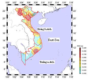
is computed in terms of peak ground displacement (D), peak ground velocity (V)
and design ground acceleration (DGA) using the neo-deterministic approach
(Costa et al., 1993). The numerical synthesis of the ground motion, taking into
account the source, the wave propagation path and the local site geology,
represents the key element for the ground motion predictions. Complete P-SV and
SH seismograms are generated by modal summation technique (Panza, 1985; Florsh
et al., 1991) on a regular grid covering the whole Việt
***
Preparing the parameter of Fault Plane Solution file (*.fps),
Normally we define the seismogenic zones basing on fundamental data,
such as: crustal structure, tectonic, seismotectonic and earthquake
distribution in regarding to select one the most appropriate solution focal
mechanism in each zone. In fact, to select the focal parameter that is
extracted directly from detailed study on fault parameters. In this field, the
active fault (seismic fault) is considered as the dominating the dynamics
parameters of earthquake (focal mechanism), in addition of the experience and
expert's mindset in considering the data set.
In order to define focal parameters, there are some of these parameters
extracted through seismograph by the wave-form inversion program, but these
results are not specific enough to present for entire seismogenic zones in Việt
*** Preparing
the catalogue (*.dat)
It is established based on the basically source of Việt
*** In order
to define the seismogenic zones (*.pos) we almost use the most recently
upgraded date form Geological, Geophysical, Seismic, Seismotectonic database.
For identification of seismogenic zones, the following principles are used:
- Possible earthquake genesis zones,
that were the active faults or a system of tectonic active faults where the
tectonic movement is quite differentiated. The possibilities of earthquake
occurrences in deep faults depend on their scope, characteristics and intensity
of tectonic activities. The most likely earthquake occurrences (seismic
activities are stronger, more regularly happened) are marginal deep faults,
which are bounded by neotectonic structural zones. Earthquake could occur
inside (internal part) of faulted zones but the intensity is weaker.
- Width of earthquake genesis
zones and relative location in comparison with the projection profile of the
fault on the surface depending on the fault movement style, dipping direction
of the faults and thickness of the active layers. Based on the extrapolations
principle the faults are regarded as having the same characteristics and the
same possibility of earthquake genesis.
- Analysis resulted in classification of the study areas into seismogenic
classes based on the combination of 4 factors, including: seismogenic fault
zones, seismic tectonic structure zones, focal source parameters, and seismic
stream density zone. According to the studied results obtained from the
above-applied method 30 seismogenic zones could be determined in the
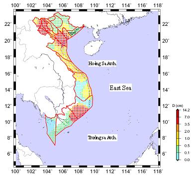
Figure 1. Maximum
displacement (Dmax) in the mainland of Việt
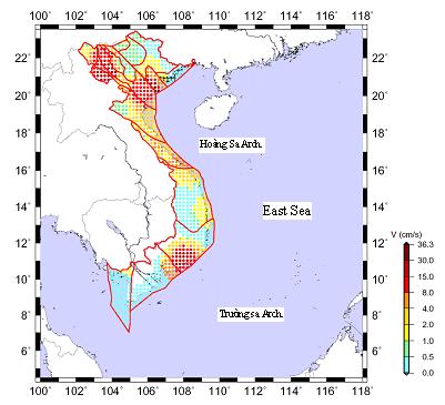
Figure 2. Maximum velocity (Vmax) in the
mainland of Việt