FEATURES OF ANCIENT RIVER-BEDS AT THE
CONFLUENCE OF RED, ĐÀ AND LÔ RIVERS AND THEIR RELATIONS WITH NEOTECTONIC
ACTIVITIES
PHẠM ĐÌNH
THỌ1, HẠ VĂN HẢI2 , HẠ QUANG
HƯNG2
1Department
of Geology and Mineral Resources of Việt Nam, 6 Phạm Ngũ Lão,
Hà Nội
2Hà Nội University of Mining and Geology, Đông
Ngạc, Từ Liêm, Hà Nội
Abstract: The confluence area of the Red, Đà and Lô rivers is the place
where three Red River, Chảy
River and Lô River great
faults meet one another. Geologists have been proving that there are
indications of contemporaneous activities of these fault, that made these
rivers to leave the northwest-southeast direction. New research results have
been showing that these fault systems were cross-cut by a younger
sub-meridional fault zone. Just neotectonic activities were the main causes of
current change of these rivers as well as their reunion in the Việt Trì
Town, and made the Đà River to change suddenly its flowing direction
from northwest-southeast to the north, then to empty into the Red River in Ba
Vì District (Hà Tây Province). The reasearch results displayed in this article
present our new judgements about the relationship between neotectonic movements
and the river network in the studied area.
I. INTRODUCTION
During recent years, the
Red River fault zone has been studied by home and foreign geologists and geophysicists.
Almost all research works have been recognizing the largest scale of the Red
River fault zone in Việt Nam
and its clear contemporaneous activities. According to P. Tapponier et al [8],
during Pliocene-Quaternary, the Red River
fault zone is a dextral strike-slip with maximal horizontal compression stress
field of submeridional direction.
The
newest results of geodetic and geophysical measurements (2001-2005) of the Institute of Geosciences
(VAST) have been showing that the Red River
fault is suffering the strike-slipe with the rate of < 1 mm/year.
So,
why the Red River which flows in the northwest-southeast direction from the
Vietnam-Chinese border through Lào Cai, Yên Bái provinces suddenly winds and
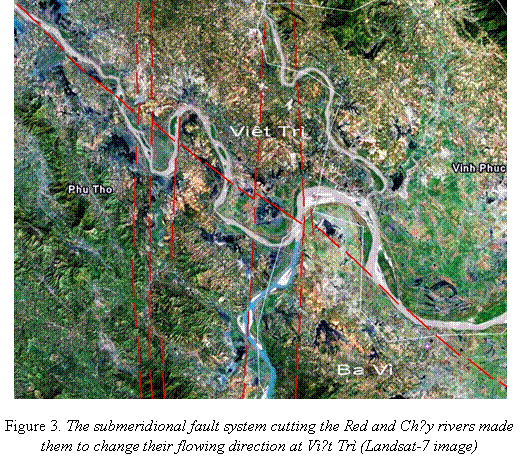
changes its direction at Phú Thọ and Việt Trì? Why this area became
the confluence of the four Red, Lô, Đà and Đáy rivers ? Is there any
relation between the change of flowing direction in this area and the
geological structure and neotectonic activities. We will touch upon these
problems in this article.
II. FEATURES OF ANCIENT
RIVER-BEDS DURING CENOZOIC
The confluence area of
the Red, Lô and Đà rivers is of hilly and plain relief with a thick cover
and few outcrops. Therefore, we chose the way to apply methods of remote
sensing, geomorphology and geophysics. These methods allow to restore the
ancient river networks through different geological periods and to draw
judgements about neotectonic activities. In the isobed map of Cenozoic sediments
[1] (established on the basis of deep seismic data of PetroVietnam
Corporation), we can note that, at the beginning of Cenozoic, the relief of
Bắc Bộ Plain from Việt Trì Town to East Sea was a low
depression of northwest-southeast trend. Basing on the topographic form and
facies of sediments in boreholes of PetroVietnam, we drew the position of
ancient beds of the Red and Lô rivers. In this map, at the beginning of
Cenozoic, these rivers were clearly oriented in northwest-southeast trend (Fig.
1).
By using the
morphometric method, the map of summit surface of the hilly and mountainous
areas in the East Bắc Bộ has been established. Based on deep-seismic
data, the isobed map of Pliocene sediments in plain area has been also
compiled. The content of these two maps is displayed in association in the Fig.
2. On the isobed map of Pliocene sediments, the position of ancient bed of the
Lô River in Pliocene has been assumed and localized, but one can see that the
ancient bed of the Red River does not pass
through the present Bắc Bộ Plain.
The geological map of
Việt Nam [7] displays
a band of N2-Q1 alluvial sediments which extends up to
100 km from Sơn Tây through Lương Sơn (Hòa Bình Province) to Ninh Bình. By analyzing the
topographical form and sedimentary facies, we can easily recognize that the
band of above alluvial sediments is just the ancient bed of the Red River in Pliocene - early Pleistocene (Fig. 2) [1].
This event conforms to the tectonic
regime of the Hà Nội Depression. During Oligocene-Miocene (28-32 Ma.),
this depression suffered the spreading and acted as a negative flower structure
[1]. Under the submeridional compression effect (at 5 Ma.) from the south, it
was compressed, uplifted and became a positive flower structure. These
movements made the Red River to change its bed
to the west and to flow along the margin of the Bắc Bộ Plain. And
as a result, it formed the above said band of N2-Q1 alluvial
sediments.
In the geological map of
Hà Nội City, the Lower Pleistocene alluvial sediments (Q11)
are absent [6], that is in accordance with above judgement – i.e. in early
Pleistocene, the Red River did not pass
through the Hà Nội area. To middle Pleistocene, the bed of the Red river moved eastwards and passed through this
area.
The traces of this ancient bed of the Red River are fluvial sediments of the Middle-Upper
Pleistocene Hà Nội Formation (Q12-3 hn),
seen in the Sóc Sơn and Đông Anh areas of the geological map, as well
as in boreholes within the Hà Nội City area. And they proved that the Red River started to pass through the Bắc Bộ
Plain since the Middle Pleistocene up to present time.
In the Geological map of Việt Nam [9], we can recognize the existence of a
band of Miocene sediments along the riverside of Red River
extending from Lào Cai, Yên Bái to Ba Vì. The distributive area of these
sediments lets see that, during Miocene there existed a long lake extending in
northwest-southeast direction up to nearly hundreds of kilometres, that
coincides with the position of the Red River Fault (Fig. 2). The Miocene
sediments with the thickness of hundreds metres contain coal seams formed in lacustrine environment. Along the
riverside of Lô River, a band of similar coal-bearing sediments occurs in Tuyên
Quang.
The existence of these
two bands of lacustrine sediments allows to draw the following conclusion:
during Miocene, the Red River was blocked in
Việt Trì, and the Lô River – in Tuyên Quang. This led to the formation of
lakes with the length of nearly tens to hundreds kilometres in the above areas.
|
|
Ancient river bed
Ancient river bed
|
|
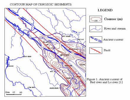
Figure
1. Ancient bed of the Red and Lô
rivers [1].
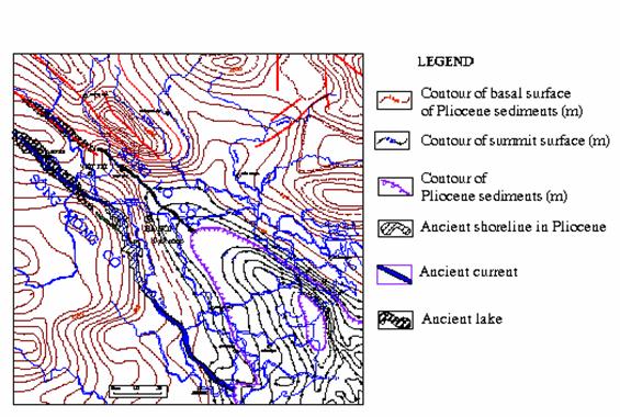
Figure
2. Ancient bed of the Red and Lô rivers displayed on the summit surface
and isobasal map of Pliocene sediments in the Bắc Bộ Plain [1].
In our recent articles,
we have presented some new discoveries about the submeridional fault extending
through the Hòa Bình Town
and Ba Vì and northwards to the Vietnam-Chinese border. There were clear signs
of this fault in geological, geomorphological, geophysical, remote sensing and
geochemical data. Just this fault zone
blocked the Red River in Việt Trì and
the Lô River in Tuyên Quang to form the above said long lakes. The change of
flowing direction of the Đà River is also related to the activities of
this fault zone.
As above analyzed,
during Miocene, a long lake was located in the Ba Vì area with a length of hundreds kilometres. That’s
why it could not be reasonable for the existence of the Đà River in this
area. At that time, this river flowed in the northwest-southeast direction
passing through the Mai Châu Townlet and, probably, emptying into the Mã River
(?).
At present, the Đà
river is flowing in northwest-southeast direction to the Hòa
Bình Town,
then winds its current northwards and empties into the Red
River at Ba Vì. So, in the Quaternary the Đà River flowed
across a band of Miocene sediments. Studying on the Hòa Bình - Ba Vì section of
the Đà River, we could not find Lower Pleistocene fluvial sediments. This
leads to the opinion that, this section was formed only in Middle-Late
Pleistocene. Since Middle Pleistocene, the Đà River changed its current,
flowed northwards and emptied into the Red River
as seen at present.
Thus, we can come to the
judgement that, the activities of the Hòa Bình - Ba Vì - Sơn
Dương - Mèo Vạc fault zone changed the river network, leading
to the confluence of the Red, Lô and Đà River at Việt Trì.
III. MANIFESTATIONS OF CONTEMPORANEOUS
ACTIVITIES OF TECTONIC FAULTS
As presented above, the
river network in the study area has close relationship with neotectonic
activities, especially, with the activities of the Hòa Bình - Ba Vì - Sơn
Dương - Mèo Vạc submeridional fault zone. Evidences about its
existence and recent activities were shown in articles [2, 3, 4] in 2003 - 2007
years.
The activities of this
fault zone are related to the phenomena of strong land splitting and landslide
in the area of Ông Tượng Hill in 1998, and water loss of the
Phương Lâm swamp in the Hòa
Bình Town
[2]. The phenomena of current change and strong scouring of the Đà River
at the Tân Đức Commune (Việt
Trì Town)
are also related to the activities of this submeridional fault zone [4].
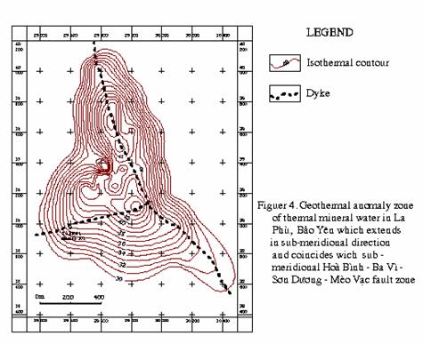
During the process of study, searching and prospect
evaluation of thermal mineral water at La Phù (Phú Thọ Province) of the
Association of Sciences and Production of Mineral Water in 2001 [5], geologists
drilled some wells and determined that, this is thermal mineral water with the
temperature of 37-44°C and the total dissolved solids of 2500-3500 mg/l. The radon
content of the mineral water in the borehole LK.12 of this area was analyzed,
reaching 4.28 nCi/l. The results of geothermal measurement of 83 points in the
La Phù area by geophysical instruments of the Geophysic Division (VAST)
associated with results of measuring temperature of mineral water from
boreholes have been allowing to establish the geothermal map of the area.
However, due to the limited expenditure the studied depth reaches only about 40
m.
This map shows that the geothermal anomalies extend in the
submeridional direction along the left dyke of Đà River [5] in La Phù and
Bảo Yên communes, Thanh Thủy District, among them, there are 2
occurrences having the maximal temperature of 44°C (Fig. 4).
In 2005, at Phong Vân Commune, Ba Vì District, situated on
the right side of the Đà River, the thermal mineral water similar to that
in La Phù has been discovered in boreholes. The above places have
manifestations of thermal mineral water almost coinciding with the position of
submeridional faults, which were discovered on the basis of remote sensing data
and of the isobed map of Cenozoic sediments in Ba Vì area. This allows to judge
about the close relationship between thermal mineral water and the
submeridional fault. The thermal mineral water is the manifestation of
neotectonic activities, and as a clue, the submeridional faults in this area
are contemporaneous active faults.
In the other side, the radon anomaly is also the evidence
of neotectonic activities. The existence of radon in mineral water has been
adding more evidences to make the above judgements more reliable.
By analyzing the neotectonic stress field we recognize
that, under the horizontal compression of submeridional direction, the
northwest-southeast trending faults, such as Red River, Chảy River and Lô
River ones, became dextral strike-slip faults; as for the submeridional one
acted like a spreading fault.
Besides, many veins of hydrothermal quartz cross-cutting
all formations in the La Phù thermal mineral water have been observed. They
could be related to above said submeridional faults.
IV. CONCLUSIONS
The above research results have been proving the close
relationship between the river network and neotectonic activities. Some
conclusions can be drawn from this as follows:
1. During Oligocene - early Miocene, the Red and Lô rivers
flowed in the northwest-southeast direction through the Việt
Trì Town
to the East Sea. To Miocene, the Red
River was blocked in Việt Trì to form a long lake with the
length of hundreds kilometres. It led to the formation of Miocene
coal-bearing beds. At the same time, the
Lô River was blocked in Tuyên
Quang Town
to form similar type of coal-bearing beds.
2. During Pliocene - early Pleistocene, the Red River
flowed along the western margin of the Bắc Bộ Plain, passing
through Sơn Tây and Lương Sơn townlets (Hòa Bình Province) to Ninh Bình Town.
In Middle Pleistocene, the Red River
changed the flowing direction eastwards to flow across the Bắc Bộ
Plain, forming the alluvial Hà Nội Formation.
3. The Hòa Bình - Ba Vì section of the Đà River flowed
in the submeridional direction cros-cutting Miocene sediments, therefore, it is
younger than Miocene. Its age probably is Middle Pleistocene - Holocene.
4. The submeridional fault zone (Hòa Bình - Sơn
Dương - Mèo Vạc) cross-cutting the Ba Vì area is a great fault
zone with the destructive zone of nearly tens kilometres. Its clear
manifestations can be found in materials of geomorphology, remote sensing and
aeromagnetic survey. It has also relation with thermal radon mineral water in
this area, therefore is neotectonic active faults. It has serious influences in
the structural plan of this area and is the main reason of the change of
flowing direction of the Red, Lô and Đà rivers in this area.
This article is completed under the support of the Project
7.204.06 of the Basic Research Program, Ministry of Sciences and Technology.
REFERENCES
1. Hạ Văn Hải,
1993.
Geomorpho-logical features and the history of recent tectonic development of
the Northeast part of Vietnam.
Geography-Geology Doctor thesis. Library of the Hà Nội University of Mining and Geology (in Vietnamese).
2. Hạ Văn Hải,
2003. Some
new discoveries about recent activities of the Hòa Bình - Sơn
Dương - Mèo Vạc sub-meridional fault zone in the North Việt
Nam.
Scientific-technological J. of Mining and Geology, 3/2003 (in Vietnamese).
3. Hạ Văn Hải,
2005. About
the causes of dyke splitting and riverside erosion in Ba Vì, Hà Tây. Scientific-technological
J. of Mining and Geology, 1/2005 (in Vietnamese).
4. Hạ Văn Hải,
2005. About
the sub-meridional faults active during Pliocene-Quaternary in the East Bắc
Bộ. J. of Earth sciences, 2/2005. Hà Nội (in Vietnamese).
5. Lê Tứ Hải (Editor),
2001.
Report Research of mineral water in Thanh Thủy District, Phú Thọ
Province. Phú Thọ
(in Vietnamese)
6. Nguyễn Đức
Đại, 1996.
Report of Urban geology of the Hà Nội City. Division of Hydrogeology and Engineering
geology of the North, Hà Nội (in Vietnamese).
7. P. Tapponnier et al., 1982. Propogating extrusion tectonic in Asia: New insights from simple experiments with
plasticine. J. Geology, 10 : 611-616.
8. Trần Đức
Lương, Nguyễn Xuân Bao (Editors-in-chief), 1988. Geological map of Việt
Nam
at 1:500,000 scale. Gen. Dept of Mines and Geology, Hà Nội.
9. Vũ Nhật Thắng
(Editor), 2003.
Geology and mineral resources of Hà Nội City. Division of Geological
Mapping of the North. Hà Nội (in Vietnamese).
10. Phạm Đình Thọ
et al., 2006.
Evolution of Cenozoic sedimentation in the Tuyên Quang Depression. J. of Earth sciences
(in Vietnamese).