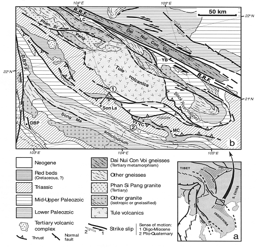
Figure 1: Location and tectonic sketch of
NW Việt
DEFORMATION OF CRETACEOUS RED SANDSTONES IN
NORTHWEST VIỆT
PHAN TRỌNG TRỊNH1 AND ROBIN LACASSIN2
1Institute
of Geological Sciences, VAST, Chùa Láng Str., Đống Đa, Hà Nội
2Institut de Physique du Globe de Paris, 4 Place Jussieu, 75252 Paris
Cedex 05, France
Abstract: We study several unconformity sites in Northwest
Việt
INTRODUCTION
Asian crust has been
structured by several collisional events [8, 23]. Amongst these events, the
Indosinian or Cimmerian orogeny is
thought to have affected a large region from Northeast Tibet to
Figure 1: Location and tectonic sketch of
NW Việt
I. THE INDOSINIAN UNCONFORMITY IN THE ĐÀ RIVER AREA
In the North and Central
Việt
South of the Sông Đà
valley, in the Sơn La and Mộc Châu areas, a discontinuous stripe of red beds
(Fig. 1b), reportedly of Cretaceous age, is mapped discordantly on the folded
Triassic series [1,15-17,29]. Geological maps and satellite images suggest that
this stripe is cut or bounded by strike-slip faults and thrusts (Fig. 1b). We
report here detailed observations
along two key
sections: north of Sơn La (section 1, Fig. 2a) and across the Yên Châu
basin (section 2, Fig. 2c), which allow us to assess in the field the
relationships between the red beds and Triassic rocks. The first section (Fig.
2a), from the Đà River to Sơn La, shows red conglomerates and sandstones,
mapped as Cretaceous, outcropping in a small basin within the Triassic series.
Towards the SW, the Middle Triassic limestones (Anisian according to [4, 15,
29] are tightly folded in a series of anticlines and synclines whose axes trend
from NW-SE to WNW- ESE. These limestones probably overthrust the Mường La red
bed basin (Fig. 2a), though contact between the two units has not been observed
directly in the field. The red sandstones and conglomerates of this basin dip
15-30° SW on average. Towards the NE, they overlie unconformably a series of
shales, sandstones and quartzites of Triassic age. On a single outcrop along
the road (UTM coordinates 48Q VJ 001 691) one can observe the red conglomeratic
beds, dipping 20-30° SSW, lying directly on the top of schistose, steeply
dipping sandstones and shales (Figs 2b and 3a). Up to the Sông Đà valley, the rest of the
section shows a nearly vertical flyschoid series with shale, grey and yellowish
sandstone and quartzite, reportedly of Ladinian age [15, 29]. These rocks are
epimetamorphic and affected by fracture or slaty cleavages (Fig. 3b). The
bedding planes trend N120-130°E and dip steeply to the NE or SW, while the
cleavage generally dips to the NE (Fig. 3b). The constant bedding (S0)-cleavage
(S1) relationships, together with polarity criteria (graded bedding, shape of
refracted cleavage, load and flute casts) suggest that this nearly vertical
series is roughly monoclinal (Fig. 2a). The northernmost part of the section,
near the Sông Đà valley, shows mylonitic metatuffs and rhyolites, with a
N110°E-trending schistosity dipping to the NE or nearly vertical. These
rocks are probably thrusted southwestward onto the
flyschoid series.
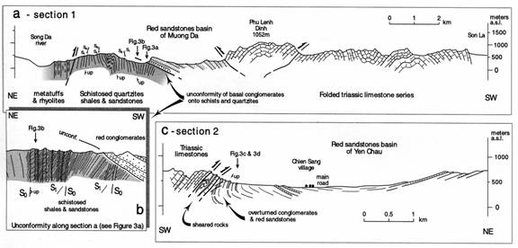
Figure. 2. Geological sections across red bed basins of Sông Đà area, (a) Section
along unpaved road from Sơn La to Đà River (section 1, Fig. Ib); NE to the
left. (b) Detail of unconformity of conglomerates onto schistose sandstones and
shales (outcrop of Fig. 3a). (c) Section of southern border and middle part of
Yên Châu basin (section 2, Fig. Ib), NE to the right. Main road from Sơn La to
Mộc Châu is in the middle of section.
II. EVIDENCE FOR SHORTENING OF THE RED BED SERIES
The second section
crosses the southern border of the Yên Châu red-bed basin, 50 km SE of Sơn La (Fig.
2c). Hills of Middle Triassic limestones, dipping to the SW, bound the basin to
the south. These limestones are thrusted towards the north onto the red
conglomerate, sandstone and pelitic series. A 250-m thick zone of sheared
limestone, pelite and sandstone marks the thrust contact and shows intense
boudinage, microfolding and small reverse shear-zones (Fig. 2c). Overturned to
nearly vertical thick beds of red conglomerate, also cut by reverse faults and
shear zones, outcrop just below this sheared zone (Fig. 3c, d). These
conglomerates contain mainly limestone and sandstone pebbles, with a few quartz
pebbles. We have not found pebbles of plutonic or metamorphic rocks. Towards
the north and upward, the series become less conglomeratic and grades into
fine-grained sandstones and pelites, that form the middle part of the basin.
South of the Chiềng Sang village the sandstones dip ~20° NE while they dip
gently to the SSW north of the road from Sơn La to Mộc Châu (Fig. 2c). We have
not reached the northern border of the basin along this section. Nevertheless,
between Yên Châu and Mộc Châu, the morphology of the Yên Châu basin on
satellite images and in the field implies that thrusts may also follow this
northern border (Fig. 1b). The Yên Châu red-bed basin thus appears to be a
pinched syncline bounded on both sides by reverse faults.
III. K/Ar DATING OF VERY LOW GRADE SEDIMENTS
Samples
from very low grade metamorphic sediments were collected from Sông Đà zone in order to reveal the
tectonometamorphic and geodynamic history of the area. 5 samples were chosen
for K/Ar dating on fine mineral fractions (<2 µm and <0.2 µm) and accompanying
illite-crystallinity measure-ments (IC) [31]. The method of K/Ar dating on fine
mineral fractions has proven to be a powerful tool in determining the age of
synkinematically grown illites, and therefore, a means for elucidating the
history of deformation and metamorphism in sedimentary rocks. Grain size
fractions <2µm (up to the higher Anchizone) are often contaminated by
detrital illite components leading to mixed ages, which can only be interpreted
as maximum ages for the deformation and metamorphism. In these cases, the
<0.2µm fractions are much more meaningful, because of its higher content of
synkinematically grown illites. From the highest Anchizone to the Epizone
inherited age information of detrital components are deleted and, in most cases,
the age of deformation is indicated by the <2µm fraction. In any case, the
age of very low grade metamorphism deduced by K/Ar dating of fine mineral
fractions is controlled by many factors and has to be interpreted carefully.
The main factors to be taken into account for the interpretation are: (1) the
maximum temperature of the very low grade overprint, (2) the stratigraphic age
of the determined strata, (3) the estimated age of detrital components, (4) the
difference in age of different size fractions from the same sample and (5) the
lithology and the mineralogical and chemical composition of the sample. In the
Sông Đà region, five rock samples were taken near Vạn Yên and NE of Sơn La. The
collection comprises Permian volcanic rocks and Triassic slates, all of
apparent high anchizonal overprint. The data scatter from 225 to 177 Ma in the
<2µm fraction and from 206 to 159 Ma in the <0.2µm fraction. Most of the
data are contaminated by detrital components in ages and IC-values. The most
reliable ages are given by a deformed volcanic rock, in which detrital
influences can be excluded (VN 2-96, 177 Ma, 159 Ma). As the deformed Triassic
rocks are unconformably overlain by undeformed Cretaceous strata, the observed
deformation and degree of metamorphism (app. 300 C) must have taken place
between the Late Triassic and Late Cretaceous [9]. It is difficult to explain
by sedimentary overburden, because app. 10 km of Lower and Middle Jurassic
sedimentary rocks would be needed for the degree of metamorphism. It is therefore
postulated that the very low grade overprint of the Sông Đà region (around
180-160 Ma) was caused by tectonic event.
DISCUSSION
The detailed field
observations we report here definitively demonstrate that the red bed series of
the Sông Đà region have been deposited on previously deformed Triassic rocks.
The steep and schistose sandstones and shales lying below the unconformity
strongly supports the idea that the red-beds are not on lapping onto a
block-faulted region, as in Central Yunnan [10], but instead postdate a
compressional tectonic event. Note however, that the underlying rocks are only
epimetamorphic and that the red conglomerate is not a polygenic molass
containing a lot of metamorphic and plutonic pebbles. This could imply that, in
the Sông Đà region, the preunconformity compressional event has not brought to
the surface deep metamorphic units, such as those typically found in internal
parts of a mountain belt. From available data, it is difficult to assign an unequivocal
age to this compressional event. During the first half of the century, the red
beds were assigned to from Upper Triassic to Lower Triassic. It was the
so-called "terrain rouge" inferred to be "Infralias" and
syntectonic by Deprat [2, 3], then by Fromaget [6]. A Cretaceous age is now
ascribed to these red beds, that could perhaps be as young as Late Cretaceous
to Early Cenozoic [17, 30]. Indeed, they reportedly contain Cenozoic remains
and a freshwater fossil [17]*.
¯¯¯¯¯¯¯¯¯¯¯¯¯¯¯¯¯¯¯¯¯¯¯¯¯
* According to newly collected fossils, the red beds at Yên Châu have been dated as Late Cretaceous (Lê Thanh Hựu, Vũ Xuân Lực, 2003, TC Địa chất, A/279)(E.B).
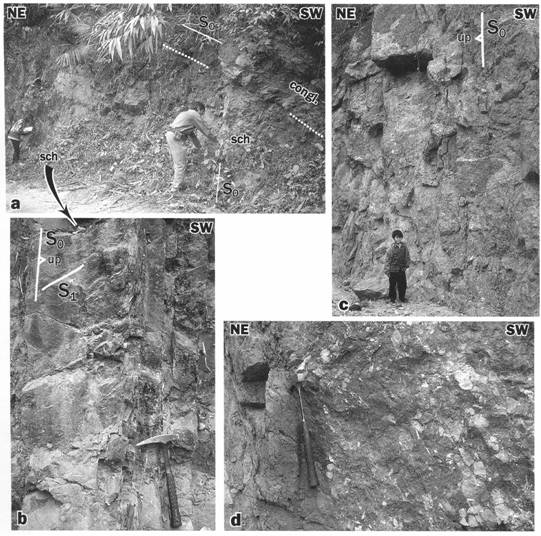
Fig 3. (a) View of red bed unconformity along Sơn La - Đà River (Fig 2.). The dotted
white line outlines the base of conglomeratic beds (congl.) above nearly
vertical to overturned schist and sandstone (sch); S0 is bedding.
(b) Detail of schistose sandstone (left part of Figs 2b and 3a). Spaced
fracture cleavage in coarser sandstone beds (left) grades into penetrative
slaty cleavage in schist (middle). Curved shape of cleavage, due to refraction
more important in coarser part
of sandstone bed (left), outlines gradded bedding and is used as polarity
criteria.
(c) Nearly vertical red conglomerates at southern border of Yên Châu basin
(Fig. 2.).
(d) Detailed view of conglomeratic beds
of Fig. 3(c): pebbles, rounded to angular,
are mostly sandstone and limestone.
Hammer handle out bedding
The possible ages for the
deformation of the underlying Triassic rocks thus range between the Middle-Late
Triassic and probably the uppermost Cretaceous. In any case, the unconformable
red beds can not be younger than the volcanic and hypovolcanic complex that
overprint the unconformity south of the Phan Si Pan range (Fig. 1). One Ar/Ar
radio-metric result [25] on phlogopite-rich lavas (cocites) suggests an age of
about 30 Ma for this complex. Triassic ages of metamorphism and deformation
have been obtained from the Sông Mã anticlinorium (~30 km south of Sơn La, Fig.
1b) and farther south in Central Việt Nam [12, 13]. This supports the
hypothesis of an Indosinian (Late Triassic) deformation in the Sông Đà region.
We cannot exclude, however, the existence of a Jurassic or Cretaceous event
also suggested by some radiochronological results in the region [13]. At most,
this deformation could even be related to the onset of the India-Asia
collision, as it is inferred in
It is clear, however,
that the basal unconformity, and the red-beds themselves are involved in the
fold and thrust edifice of the Sông Đà region. This implies
that post-Cretaceous shortening, likely an effect of the
India-Asia collision, has been being strong in the northern part of the
ACKNOWLEDGEMENTS
This work is a result of the cooperation
program between the Centre National de la
Recherche Scientifique (
REFERENCES
1. Bùi Phú Mỹ (Editor),
1978. Geological map of the Socialist
Republic of Việt
2. Deprat J., 1914a. Les charriages de la region de la Riviere-Noire sur les
feuilles de Thanh-ba et de Van-yen. Mem.
Serv. Geol. Indochine, 2 : 47-65. Hà
Nội.
3. Deprat J., 1914b. Etude des plissements et des zones
d'ecrasement de la moyenne et de la basse Riviere Noire. Mem. Serv. Geol. Indochine, 3
: 1-59. Hà Nội
4. Deprat J., 1914c. Etude preliminaire des terrains triasiques du Tonkin et du
Nord
5.
6. Fromaget J., 1941.
L’Indochine francaise, sa structure geologique, ses roches, ses mines et leurs relations possibles avec la
tectonique. Bull. Serv. Geol. Indochine, 26/2 : 140 pp. Hà Nội.
7. Fromaget J., 1952.
Etudes geologiques sur le Nord-Ouest du Tonkin et le Nord du Haut-Laos-2e et 3e
Parties. Bull. Serv. Geol. Indochine, 29, 198pp. Hà Nội.
8.
9. Lacassin
R., Leloup H., Phan Trong Trinh & Tapponnier P. 1998. Unconformity of
red sandstones in North Việt
10. Leloup P.H., Lacassin R., Tapponnier P., Zhong Dalai,
Liu Xiaohan, Zhang Lianshang, Ji Shaocheng and Phan Trong Trinh, 1995. The Ailao Shan - Red River shear zone (
11. Leloup P.H., N.
Arnau, R. Lacassin, J.R. Kienast, T.M.
Harrison, Phan Trong Trinh, A. Replumaz and P. Tapponnier, 2001. New constraints on the
structure, thermochronology and timing of the Ailao Shan – Red River shear
zone,
12. Lepvrier C.,
Maluski H., Nguyen Van Vuong, Roques D., Axente V. and Rangin C., 1997. Indosinian NW-trending shear zones within the Truong Son
belt (Việt
13. Maluski H., Lepvrier C., Roques D., Nguyen
Van Vuong, Phan Van Quynh and Rangin C, 1995. 40Ar/39Ar ages in the Danang-Dailoc plutono-metamorphic complex
(Central Việt
pp. 65-66.
14. Nguyễn Trọng Yêm,
Phan Trọng Trịnh,
Phùng Văn Phách, 1991. Geological structure and
stress field of Hòa
Bình region and its surrounding areas. Proc. 2 Conf. on Geology of
15. Nguyễn Vĩnh (Editor),
1978. Geological map of the Socialist
Republic of Việt
16. Nguyễn Xuân Bao (Editor),
1978. Geological map of the Socialist
Republic of Việt
17. Phan Cự Tiến, 1988, 1989. Geological map of
18. Phan Trọng Trịnh, 1993. Cenozoic great overthrust in Hoà
Bình and its surrounding area. J.
Geology, A/214-215: 30-35. Hà Nội (in Vietnamese with English abstract).
19. Phan Trọng Trịnh, Tạ Trọng
Thắng, Nguyễn Đăng Túc, 1996. Deep deformation along the
20. Phan Trọng
Trịnh, Trần Văn Trị, Nguyễn Cẩn, Đặng Văn Bát, Phạm Huy Tiến, Văn Đức Chương,
Hoàng Quang Vinh, Lê Thị Lài, Đoàn Văn Tuyến, Trần Trọng Huệ, Nguyễn Văn Hùng,
Nguyễn Địch Dzỹ, Trần Đình Tô, Nguyễn Trần Hùng, Đòan Kim Thuyên, Huỳnh Tước.
1999. Active tectonics and seismic hazards in Sơn La hydropower dam (North
Việt
21.
22.
23. Sengor
A.M.C. and Hsu K.J., 1984. The Cimmerides of
24. She Fa
Chen,
25. Sun Li Chung, Tung Yi Lee, Ching Hua Lo,
26. Tapponnier P., Peltzer G. and Armijo R., 1986. On the mechanics of the collision between
27. Tapponnier P., Lacassin R., Leloup P.H., Scharer U.,
Zhong Dalai, Liu Xiaohan, Zhong Jiayou, 1990. The Ailao Shan/Red River metamorphic belt: Tertiary left-lateral shear
between Indochina and
28. Tapponnier P.,
Leloup P.H. and Lacassin R., 1996. The Tertiary tectonics of South China
and
29. Trần Đăng Tuyết (Editor),
1978. Geological map of the Socialist
Republic of Việt
30. Trần Văn Trị (Editor),
1973. Geological Map of Việt
31. Wemmer K., H. Sievers, Tạ
Trọng Thăng, Phan Trọng Trịnh, 1999. New hints for nappe tectonics in North
Việt