WATER PROBLEM IN THE STRATEGY FOR SOCIO-ECONOMIC DEVELOPMENT
OF NAM ĐỊNH PROVINCE
ĐÀO HUY QUÝ, LÊ ĐỨC NGÂN, ĐÀO MẠNH TƯỜNG
Nam Định Department of Science and Technology
Abstract: Located in the south of the Bắc Bộ Plain, the Nam Định Province possesses an abundant water
reserve, able to meet the socio-economic development requirement. However, the
surface water begins to be polluted by discharge of untreated waste-water into
canals and rivers, and the groundwater starts decreasing in quantity due to the
uncontrolled exploitation. The paper sets forth some recomendations for a
sustainable exploitation and use of the water resource in the province.
I. GENERAL VIEW
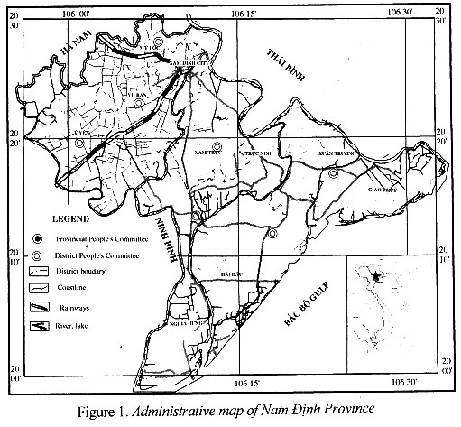
1. Location
The Nam Định Province in located in the south of the
Red River delta. Its total area is 1.638.07 km2, including 10
administrative divisions. The total number of communes is 226, among them there
are 15 precincts and 9 townlets.
It is bordered in the east by Thái Bình province, in the west by Ninh Bình
province, in the south by the Bắc Bộ gulf.
2. Socio-economic dimension
Population:
1,945,661, population growth rate: 0.96 %/year.
Economy:
- Economic growth: period
2001 – 2003: 7.7 %/year.
- GDP in 2003: 7,481,750
million VND; among them: agriculture, forestry, aquaculture: 2,759,090 million
VND; industry and construction: 1,876,645 million VND; service: 2,846,015
million VND.
- Economic structure: from 2001 to 2003, it was planned to reduce
agricultural sections and to increase industrial, service sections (2003):
agriculture, forestry, aquaculture: 36.88%; industry and construction: 25.08%;
service: 38.04%.
Main strategies for socio-economic development till 2010:
-
GDP growth rate: 8.5%;
- Agricultural, forestry, aquaculture revenue
growth rate: 3.5%;
-
Industrial revenue growth rate: 25%;
Service
revenue growth rate: 8.2 - 8.5%.
In order to accomplish these
tasks, Nam Định has carried out 6 socio-economic programs which are set forth by
the Provincial Party Congress.
-
Industrial and craft industrial development programs;
-
Marine economy development program;
- Agricultural development and new country construction programs
- Poverty-alleviation movement
- Social evil elimination
programs
- Consolidating programs for Communist Party,
Provincial Fatherland Front and social organizations.
II. WATER RESOURCE IN NAM ĐỊNH PROVINCE AND SOCIO-ECONOMIC
DEVELOPMENT PROGRAMS
1. Water resource for aquaculture
a. Potentiality for development
Nam Định coastal zone: Nam Định province has part of 72 km
long coastline. There are 3 large estuaries (Ba Lạt estuary of the Red River,
Lạch Giang estuary of the Ninh Cơ River and Đáy estuary of the Đáy River). The
salt-marsh alluvial area is 22,500 ha, which is favourable for aquaculture.
Planning till 2010:
Table
1. The onshore aquaculture area
(ha)
|
ID
|
Criteria
|
Current
usage
|
Till 2005
|
Till 2010
|
|
1
|
Aquaculture area in brackish - salt
water.
|
5,160
|
8,110
|
8,460
|
|
2
|
Aquaculture area in fresh water
|
2,922
|
3,072
|
3,072
|
Table 2. Interior field area for aquaculture
|
ID
|
District
|
Total area (ha)
|
Pond, lake (ha)
|
Field for aquaculture (ha)
|
|
1
|
Nam Định City
|
382
|
283
|
50
|
|
2
|
Mỹ Lộc
|
562
|
412
|
120
|
|
3
|
Ý Yên
|
3,320
|
800
|
2,500
|
|
4
|
Vụ Bản
|
1,595
|
556
|
1,020
|
|
5
|
Nam Trực
|
954
|
582
|
360
|
|
6
|
Trực Ninh
|
775
|
665
|
72
|
|
7
|
Xuân Trường
|
724
|
695
|
-
|
|
8
|
Nghĩa Hưng
|
2,774
|
928
|
1,786
|
|
9
|
Giao Thủy
|
990
|
930
|
-
|
|
10
|
Hải Hậu
|
1,358
|
1,269
|
-
|
|
|
Total
|
13,434
|
7,120
|
5,908
|
Nam Định interior area: Nam Định Province has a dense hydrological system,
including 4 large rivers: Red River, Đáy River, that are the 2 largest rivers
crossing the province, as well as Đào and Ninh Cơ Rivers that are 2 tributaries
of the Red River. The hydrology network occupies 3% of the total area. The river
density is 1,5-2 km/km2. A
preliminary estimation shows that the total annual water discharge is 120
billion m3, whereas the annual water demand is about 27 billion m3.
Hence this hydrological system and provincial irrigational works form good
potentialities for aquaculture.
b. Disadvantage
Beside potential advantages,
the province still is facing several
challenges:
- The Red
and Đáy rivers receive polluted components from the upper source (Hòa Bình, Hà
Nam, Hà Nội, Sơn Tây, …) before running across the province. The monitoring
results from several observation stations in rainy and dry seasons have been
showing that: the water quality reaches the river quality standard, because of
dilution and self cleaning. However in comparing with fresh water standard
(based on BOD, COD, Coliform, residues of insecticide, detergent…), the water
quality fails to meet the fresh-water standard. This is the consequence of the
direct discharge of untreated wastewater into the rivers.
- In the
lower section of Red, Ninh, Đáy rivers the environmental indices (BOD, COD,
insecticide residues...) are much higher than the permitted standard. The reason
is that agricultural activities in the province utilize annually approximately
300 tons of insecticides.
2. Water resources for agricultural development
a. Agricultural development planning
According to the Nam Định land use
planning till 2010, the total area for agriculture is 213,000 ha, occupying 63 - 64% of
provincial natural land, among them:
- Rice field area: 155,000 ha;
- Cereal crop area: 16,000 ha;
- Vegetable cultivation area: 28,000 ha;
- Short-term industrial crop area: 14,000 ha.
b. Water resources for
agricultural development
Nam Định has a dense hydrologic
network, including 16 small and large rivers, occupying 3% of natural land. The
river density reaches 1,5 - 2 km/km2 and the area
for irrigational works is 12,000 - 13,000 ha. This network is important for
agricultural development as it is resource and infrastructure.
c. Challenges
At present, all untreated wastewater from
industrial and living usages discharge directly into the river system.
Additionally, the large Red and Đáy rivers still receive pollutants from the
upper section before running across the province.
3. Water resource for industrial and craft industrial
development
a. Current status and planning
for industrial and craft industrial development
The main
industries of the province are: garment, processing, mechanical, electric,
electronic, construction material and oriented knowledge industries. The total
area for industrial infrastructure is 99.4 ha (5.5 % of provincial land).
Till
2010, Nam Định plans to hasten the industrial development. In the planning side,
several industrial zones will be constructed.
b. Water demand
-
Industrial water demand: 45 m3/ha/day, water demand estimation:
56,500 m3/day.
-
Estimated labour force for industrial zones: 150,000 people, water demand:
15,000 m3/day.
Total
industrial water demand is: 56,500 + 15,000 = 71,500 m3/day.
c. Water potentiality for
industry - craft industry
Nam Định
has a dense hydrologic system with an annual water discharge of 120 billion m3, in addition all industrial zones are located close
to traffic lines and surface water sources, and hence water for industrial/ craft
industrial development is favourable.
On the
other hand, groundwater (not detailed touched upon in this paper) is also
abundant for exploitation. The facing problem is to build a water supply
factory.
Table 3. Land
used in industrial production
|
TT
|
Industrial zones
|
Area (ha)
|
Water usage estimation (m3/
day)
|
|
I
|
Ongoing
industrial zones
|
99.4
|
4,500
|
|
II
|
New industrial zones
|
478
|
22,000
|
|
1
|
Hòa Xá industrial
zone, Nam Định City
|
327
|
|
|
2
|
Mỹ Trung industrial zone, Nam Định City
|
150.6
|
|
|
III
|
New industrial quarters
|
633
|
30,000
|
|
1
|
An Xá
industrial quarter, Nam Định City
|
518.8
|
|
|
2
|
Xuân Tiến, Xuân Trường
|
15.6
|
|
|
3
|
Vân Chàng, Nam Giang,
Nam Trực
|
6.7
|
|
|
4
|
Yên Xá, Ý Yên
|
3.15
|
|
|
5
|
Thịnh Long, Hải Hậu
|
15.8
|
|
|
6
|
Xuân Bắc, Xuân Trường
|
7.6
|
|
|
7
|
Nghĩa Sơn, Nghĩa Hưng
|
9
|
|
|
8
|
Cổ Lễ, Trực Ninh
|
9.84
|
|
|
9
|
La Xuyên, Yên Ninh, Ý Yên
|
7.5
|
|
|
10
|
Trung Thành, Vụ Bản
|
5.6
|
|
|
11
|
Nam Hồng, Nam Trực
|
13.8
|
|
|
12
|
Xuân Trường district
centre
|
13.7
|
|
|
13
|
Xuân Hưng, Xuân Trường
|
5.2
|
|
|
14
|
Thịnh Lâm, Giao Lâm
|
11
|
|
|
|
Total
|
1,211
|
56,500
|
d. Challenges
All
provincial industrial zones still do not have any wastewater treatment station,
in except of Hòa Xá (where the wastewater treatment station construction is
under implementation, with a capacity of 4,500 m3/day for stage 1
and a total capacity of 9,000 m3/day). All the other industrial
zones discharge directly into open channels, or let infiltrated through the
ground, that causes the water pollution.
Untreated
living usage wastewater of Nam Định City is directly discharged into lakes and
Đào River, causing water source pollution.
4. Water demand for living usage
a. Population and orientation of
urban development
Population:
1,945,661 with following distribution:
- Rural
area: 1,654,312 persons
- Urban
area: 291,349 persons
- Annual
population growth rate is 9.62% (data in 2003). The estimated population till 2010
will be about 2,039,247 with following distribution:
- Rural
area: 1,733,719 persons
- Urban
area: 305,333 persons.
b. Water demand
Table 4. Estimated water demand till 2010
|
Id
|
Water usage area
|
Norm
|
Water demand
|
|
1
|
Urban area
|
100 l/day/person
|
30,000 m3/day
|
|
2
|
Rural area
|
80 l /day/person
|
139,000 m3/day
|
|
|
Total
|
|
169,000 m3/day
|
Table 5. Average rainfall during several years
|
Months
|
I
|
II
|
III
|
IV
|
V
|
VI
|
VII
|
VIII
|
IX
|
X
|
XI
|
XII
|
|
Mean
|
27
|
34
|
52
|
76
|
183
|
196
|
232
|
311
|
334
|
196
|
64
|
28
|
|
Max
|
142
|
131
|
116
|
187
|
599
|
550
|
560
|
631
|
790
|
489
|
246
|
160
|
|
Min
|
0
|
0
|
9
|
8
|
44
|
43
|
27
|
82
|
40
|
15
|
0
|
0
|
Table 6. Maximum
and minimum mean water discharge in a month
|
Location
|
August (Qmax m3/s)
|
February (Qmin m3/s)
|
|
Red
River (observed at Phú Hào)
|
3,800
|
450
|
|
Đào
River (observed at Nam Định)
|
2,010
|
260
|
Source:
Hydrometeorology Station in 1998
c. Water potentiality for
residential usage
Water
sources for living usage include rain water, surface water and groundwater.
- Rainfall (Table 5)
-Surface water (Table 6 shows the average water quantity
in several months)
- Groundwater
According
to several groundwater investigations in Nam Định province, from preliminary
(1995) to detailed study (2004), there are six aquifers differing from one
another in water quantity and quality, two of them are exploitable, these are:
+ The
Holocene interstitial aquifer (Thái Bình Formation). This aquifer is
distributed extensively in all districts of the province. Groundwater can be found
in sand lenses of 2-3 m in thickness. These lenses lie mainly in the depth of
8-10 m and 12-15 m.
Cl
content in this aquifer ranges from 30-40 mg/l to 2000 mg/l (the study work
divides it into several levels: less than 200 mg/l occupying 25%, 200-400 mg/l
occupying 40% of total area. Local inhabitants usually exploit water in this
aquifer for daily usage.
+
Middle-Upper Pleistocene interstitial aquifer (Hà Nội Formation). This aquifer
is largely distributed in the province; it is the extension of the widely
distributed aquifer in the Bắc Bộ Plain. Main sedimentary composition consists
of quartz, gravel, sand. The distributive depth of this aquifer is relatively
stable. In the Vụ Bản district it is about 3-35 m from the surface. In the
center of Hải Hậu District, it is nearly 80-90 m or 100 m. The depth gets 60-70
m in the coastal zone. The aquifer average thickness is 28,4 m, its quality
ranges from fresh to salt-water. Geologists have defined several fresh-water
lenses distributed in Nghĩa Hưng, Hải Hậu, part of Giao Thủy, Xuân Trường,
southern part of Nam Trực, Trực Ninh districts. The total area of fresh-water
lenses is 975 km2. Iron content in this aquifer is distributed in
accordance to the rule: the fresher water contents less iron. The water with an
iron content of less than 1 mg/l has been found in Hải Hậu and a part of Nghĩa
Hưng with the total area of 105-110 km2. It is estimated that potential exploitable
reserves of fresh water in the Pleistocene aquifer are 203,445m3 per
day. These reserves comprise of static elastic reserves (177,770 m3
per day, occupying 87.37%) and penetrating reserves (25,683 m3 per
day, occupying 12.63%).
Table 7. Current status of exploitation and use of
water supply works (data of 1998)
|
ID
|
Localities
|
Number
of digged wells
|
Number of drilled wells
|
|
1
|
Nam
Định City
|
183
|
3,183
|
|
2
|
Nghĩa
Hưng District
|
7,218
|
23,542
|
|
3
|
Giao
Thủy District
|
16,599
|
2,931
|
|
4
|
Trúc
Ninh District
|
7,412
|
7,673
|
|
5
|
Ý Yên
District
|
35,956
|
2,113
|
|
6
|
Hải Hậu
District
|
12,140
|
26,267
|
|
7
|
Mỹ Lộc
District
|
4,417
|
1,204
|
|
8
|
Nam
Trực District
|
11,870
|
2,156
|
|
9
|
Xuân
Trường District
|
10,885
|
4,031
|
|
10
|
Vụ Bản
District
|
17,240
|
3,138
|
|
|
Total
|
123,920
|
76,238
|
d. Challenges
- Surface water: Wastewater from agricultural, industrial and living activities
directly discharges into rivers, but in comparing to the standard of river water
quality the pollution is under the permitted limit, however in comparing to
standard of living usage water it is several times higher.
-
Ground water: There are some signs of water table
lowering and pollution (especially with organic compounds and ammonia) in
fresh-water lenses in Nam Định Province. The reasons simply are uncontrolled
management of fresh-water exploitation and shortcomings in technical
application. At present, the investigation has been showing that zinc content is
1-5 times higher than standard value as iron content is 2-10 times higher.
Another groundwater investigation realized by the Institute of Geological
Sciences and University of Mining and Geology also shows that from 1996 to
present, the water level in water lens center decreased by 3,5 m.
III. CONCLUSIONS
AND RECOMMENDATIONS
1. The
Nam Định Province is known as a potential land for economic development (marine
economy, wet rice cultivation, industry and service) in the Red River delta. Its
water resource, including abundant surface water and groundwater, able to meet
the socio-economic development demand.
2. In
order to sustainably exploit the water
resource
of the province, in the managerial and technical point of views, following
proposals can be set forth:
a) On management
side:
Urgent
requirement of cooperation between the provinces located in the Red and Đáy
river basin in order to minimize the pollution from waste sources, especially
wastewater discharge.
Establishing
an environmental monitoring system in the province, especially for fresh- water
lenses in coastal districts.
Closely
controlling groundwater drilling enterprises, conforming to provincial planning
and technical requirement. At present this task is out of control.
b) On
the technical side:
All water
exploiting wells need to be strengthened to prevent salt-water penetration and
pollutant infiltration from surface. The well reinforcement and isolation can
be done as follows: the space between drill wall and casing should be filled
with clay. The zone of 3-5 m in depth from the surface water should be
concreted by fast hardening cement. The base should be concreted.
Exploring
and unusable wells must be filled with clay and covered by concrete.
Drilled
and digged wells should be at least 3 m far from cattle sheds and toilets.