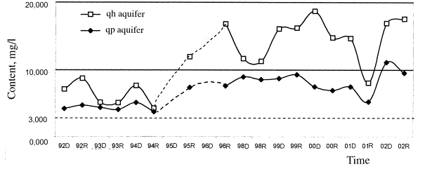
Figure 1. Diagram of the change of average content of ammonium in
groundwater
in the south of
CURRENT STATUS OF GROUNDWATER POLLUTION
IN HÀ NỘI AREA*
1NGUYỄN VĂN ĐẢN, 2NGUYỄN THỊ
DUNG
1Division of Hydrogeology - Geological Engineering of the North, Nghĩa Tân,
Hà Nội
2Department of Geology and Minerals of Việt Nam, 6 Phạm Ngũ Lão, Hà
Nội
Abstract: The water supply in
The
groundwater pollution occurs both in the Holocene aquifer (Upper aquifer) and
Pleistocene aquifer (Lower aquifer - production aquifer). The pollutant
elements are detected like nitrogen component, microorganisms, organic matter,
toxic elements: arsenic, mercury… The pollution by nitrogen components has been
studied since 90’s. The studied results showed that the main contaminant is
ammoni (NH4+), contributing in large area with high
concentration. The polluted area and concentration of pollutants are increasing
with time.
I. GENERAL OUTLINES
The Hà Nội City extends from near the centre of the Bắc
Bộ Plain to its northeast margin. With an area of about 900 km2 it
includes 7 prefectures and 5 suburban districts with the population of about
2.7 mill. persons
The major part of the Hà Nội City consists of plain land
with the surface elevation of 5-20 m, a small part in the north consists of
hilly area belonging to the southeast end of the
The mean annual rainfall reaches about 1600 mm, divided
into two seasons. The rainy season extends from May to October, occupying 85%
of annual rainfall. The remaining months belong to the dry season having an
inconsiderable rainfall.
The
On the hydrogeological side, Quaternary sediments have the
greatest importance. They are distributed in the plain area, and due to the
rhythmic character of sediments they form two main aquifers in the geological
section.
¯¯¯¯¯¯¯¯¯¯¯¯¯¯¯¯¯¯¯¯¯¯¯¯¯¯¯¯¯¯¯¯¯¯¯¯¯¯¯¯¯¯¯¯¯¯¯¯¯¯¯
* This paper was presented in the International
Symposium on Environment and Injure for Community Health caused
by Pollution during the Urbanization and
Industrialization in , Hà Nội, 12/2002.
Holocene aquifer (qh), called also as Upper aquifer, is
exposed on the surface and largely distributed continuously from the Red and
Đuống rivers southward with an area of about 530 km2. The
lithological composition of the aquifer consists of two members. The upper
member includes weakly impermeable silty clay, silty sand with the thickness
from very small to about 10 m. The lower member is composed of sand of
different sizes, sometimes mixed with gravel and grit at the base, with the
average thickness of about 9.2 m in the north of the
Water of the qh aquifer is the fresh one with the total
dissolved solids usually under 0.5 g/l, mainly of calcium bicarbonate type. The
iron content of water in the most part of area is from 0.4 to 10 mg/l, locally
greater; the manganese content – from 0.2 to 2.0 mg/l; ammonium content from
very small to very great, such as in Thanh Trì District situated the south of
the city it reaches some tens up to 100 mg/l. This aquifer is of small scale in
water-supply significance. People of rural areas usually dig wells or drill
small boreholes for exploiting water from this aquifer.
Pleistocene aquifer (qp), also called as Lower aquifer,
occurs from the south of Sóc Sơn District and is continuously developed
southward, but completely covered, therefore, met only through boreholes. The
depth of water meeting is 2-10 m in the north of the Red and Đuống rivers, 5-22
m at
The water-bearing sediments consist of sand mixed with
gravel and pebble with a thickness of from 10 to 35 m. The conductivity
coefficient (T) is 260-1600 m3/day, The elastic gravitational
water-release coefficient (m*) changes from 0.00004 to 0.066. The output quantity
(q) of experimental boreholes in most cases is over 1 l/s.m, therefore, this
aquifer is ranked to very rich in water type.
Water of the qp aquifer is the fresh one with the total
dissolved solids of from very small to 0.78 g/l, the main composition of
calcium bicarbonate, locally calcium-natrium bicarbonate-chloride. The iron
content in water is high, changing from 0.4 to 20 mg/l, locally up to 50 mg/l;
manganese content from very small to 0.33 mg/l, ammonium content in the south
of Thanh Trì District is very high; on an area of about 80 km2 this
content reaches over 10 mg/l.
Due to its richness in water, the qp aquifer is being
strongly exploited, and is the main water supply source of the Hà Nội City.
The Hà Nội City began to use groundwater as living water
since 1909 by drilling first exploiting boreholes at Yên Phụ. The exploiting
water quantity increases day by day.
In 1954 the quantity of exploited water was, in average,
20,000 m3/day. During the 60’ it was 100,000 m3/day;
during the 70’ - 200,000 m3/day; during the 80’ - 300,000 m3/day
and; during the 90’- 400,000 m3/day.
At present, water used in living purposes and
agricultural production is taken mainly from groundwater source with three main
forms:
1) Concentrated water-exploitation realized by special
institutions (companies of water business); at present they are exploiting
water in 10 large well fields and many small well fields with about 150 drill
wells. The average exploited water quantity is about 420,000 m3/day
from the qp aquifer.
2) Solitary water-exploitation realized by companies,
economic units, schools, hospitals, institutions, because they do not receive
the water supply from the city. According to incomplete statistic data, this
form of exploitation has about 500 drill wells exploiting the qp aquifer with
the total output of about 150,000 m3/day.
3) Water exploitation in the rural areas, carried out by
families with shallow boreholes of small diameter or digged wells, exploiting
mainly the qh aquifer, locally the upper part of the qp aquifer. The exploiting
equipment is rudimentary. The quantity of these wells increases in time, and it
is difficult to make the statistics. The investigation in 1999 year has been
showing that in the whole city there are about 115,000 wells exploiting water
with the total discharge of about 115,000 m3/day.
The water used in living demands will increase in time.
According to the guiding planning in water for the city, in 2010 year the water
for living purpose in the south of
II. NEGATIVE INFLUENCES CAUSED BY GROUNDWATER EXPLOITATION
The major part of great exploiting works (well fields)
has been realized after the results of exploration and evaluation of
groundwater reserves. Only some, especially solitary exploiting works and those
in rural areas were realized without any hydrogeological investigation. The
exploitation of groundwater usually leads to negative influences, such as land
subsidence, lowering of water level and pollution of water sources.
1. Land subsidence is
the phenomenon of gradual or sudden lowering of the ground surface caused by
natural or artificial process. One of the causes of land subsidence is the
groundwater exploitation. When the water level is lowered the volume of loose
and weak soil decreases leading to the land subsidence. The land subsidence of
large scale related to groundwater exploitation has been determined in many
places in the world, such as
In 1988 year, during the exploration of groundwater the
Division of Hydrogeology - Geological Engineering of the North (DHGEN)
constructed 32 landmarks for measuring the subsidence in the territory of the
city in the south of
The result of subsidence study in the 1988-1995 period
showed that almost all the city interior (in except of the Red River bank area)
and adjacent areas were subsided. The strongly subsided areas (average rate
>10 mm/year) are the central and the south parts of the city. The strongest
subsided areas (average rate of 20-44 mm/year) are
The above study on subsidence has been allowing to set
forth following remarks:
1) The strong exploitation of groundwater in the areas
having weak soil foundation (mud, peat, sediments bearing organic matter) in
the geological section causes the strongest subsidence;
2) The areas not influenced or influenced by groundwater
exploitation, but having not weak soil foundation (such as the band along the
Red River bank) are not subsided;
3) The subsiding rate tends to decrease in time, among
this in the strongest subsided Pháp Vân area the subsiding rate has been
changing from about 60 mm/year at the beginning of the studying period to about
40 mm/year recently, in the strongly subsided Thành Công area – from 40 to 25
mm/year, in the weakly subsided Mai Dịch area – from 12 to 5 mm/year.
4) The cause of land subsidence can be numerous, but the
groundwater exploitation is the main one.
2. The lowering and
enlargement of lowering funnel of water level
The strong groundwater exploitation has been having
strong influence to the groundwater regime, especially in the south of the
1) Areas influenced by exploitation having the water
level under 0 m;
2) Areas of strong influence having the water level
under -8 m;
3) Areas of very strong influence having the water level
under -14 m.
The funnels of water lowering have been continuously
mapped on the basis of data on average water level per month from 1992 to
present time of the qp aquifer; this has been showing the change of their area
as follows:
1) Surface of exploitation-influenced areas during
1992-1997 is annually restricted during the rainy season (September) and
enlarged during the dry season (
2) Surface of strongly exploitation-influenced areas
continuously increases from 55 km2 (in 1992) to 75 km2
(in 1997) with the rate of 4 km2/year. Then it stronger increases
and to the end of 2001 reaching 95 km2, it means with the rate of 5
km2/year.
3) Surface of very strongly exploitation-influenced areas
increases also continuously from 3 km2 (in 1992) to 14 km2
(in 1997) with the rate of 2 km2/year. To the end of 2001 it reaches
27 km2, it means with the rate of 3 km2/year.
The above watching results have been showing that the
lowering funnels of groundwater level have been continuously enlarged both in
space and in depth.
Together with the enlargement of lowering funnels, the
groundwater level has been decreasing in time. The analysis of features of
water level lowering in exploiting well fields allows to divide them into 2
groups: group of well fields in the band of Red River bank (Yên Phụ, Ngô Sỹ
Liên, Lương Yên, etc.) and group of far from
Along the Red River bank, in general, the groundwater
level is not so deep, due to the supply of the river the annual oscillation of
water level is not great. In all monitoring boreholes the water level tends to
gradually decrease in time, but the decreasing rate is not great.
In the far from the Red River areas, the groundwater
level lies very deeply, such as in the borehole P.41a situated in
the centre of the Hạ Đình well field the groundwater level is 32 m deep from
the surface, corresponding to the elevation of -25 m. Due to the small
influence of meteo-hydrological factors, the water level strongly decreases in
time with the rate of 0.3 m (Q.63a – Mai Dịch well field) to 0.4 m
(P.41a - Hạ Đình well field).
The decrease of water level leads to the resource
exhaust, that entrains a lot of disadvantageous problems, such as water source
pollution, land subsidence, etc..
III. WATER SOURCE POLLUTION
The water resource pollution is understood as a process
changing the quality of water caused by human, that makes water having
restricted use or impossible for using in intended purposes.
1. Current status of groundwater pollution
The pollution of groundwater in the Hà Nội City area has
been paid attention long ago, although the study is still not sufficient, but
it has been setting forth some remarks and alarms on the groundwater pollution.
It comprises nitrogen pollution, microbiologic
pollution, organic compound pollution, metallic element pollution, etc.. They
have been studied in different levels.
a. Pollution by nitrogen compounds
The study on pollution of groundwater by nitrogen
compounds has been carried out by the DHGEN since the beginning of 90’ of the
past century in the south of
Standards for classification of levels of pollution by
nitrogen compounds have been set forth for serving the study as seen in the
Table 1.
Table 1. Classification
of levels of pollution by nitrogen compounds
|
Pollution
matter |
Drinking
water standard, mg/l |
Limit
of content after pollution levels, mg/l |
|||
|
Clean |
Slight-dirty |
Medium-dirty |
Heavy-dirty |
||
|
NH4+ NO2- NO3- |
< 3 < 0.1 < 5 |
<0.5 <0.1 <5 |
0.5-3 0.1-0.5 5-10 |
3-10 0.5-1 10-50 |
>10 >1 >50 |
The study results have been showing that the groundwater
is polluted mainly by ammonium of high content, that continuously increases in
time and occurs on large area. The nitrate and nitrite pollution is
inconsiderable, because the localities having NO2- and NO3-
are a little and in restricted area.
The results of analysis of NH4 content from
1992 to present time in the south of
The results have been showing that:
1) Average content of ammonium in groundwater always
higher than permitted standards, among this it is higher in the qh aquifer than
in the qp aquifer; this proves that the pollution is developed in downward
direction;
Table 2. NH4+
content in groundwater in the south of
|
Year |
Season |
Holocene
aquifer (qh) |
Pleistocene
aquifer (qp) |
||||
|
Number
of studied samples |
Content, mg/l |
Number
of studied samples |
Content,
mg/l |
||||
|
Max |
Average |
Max |
Average |
||||
|
1992 |
Dry |
41 |
58.1 |
7.1 |
43 |
58.1 |
4.2 |
|
Rainy |
42 |
64.5 |
8.7 |
46 |
51.6 |
4.7 |
|
|
1993 |
Dry |
42 |
34.6 |
5.2 |
43 |
24.2 |
4.4 |
|
Rainy |
45 |
48.4 |
5.1 |
48 |
19.3 |
4.1 |
|
|
1994 |
Dry |
43 |
84.7 |
7.6 |
48 |
33.6 |
5.1 |
|
Rainy |
49 |
51.7 |
4.3 |
51 |
17.4 |
3.7 |
|
|
1995 |
Dry |
|
|
|
|
|
|
|
Rainy |
50 |
100.0 |
11.9 |
52 |
80.0 |
7.4 |
|
|
1996 |
Dry |
|
|
|
|
|
|
|
Rainy |
40 |
128.0 |
16.8 |
47 |
128.0 |
7.6 |
|
|
1998 |
Dry |
30 |
144.0 |
11.1 |
42 |
100.0 |
8.9 |
|
Rainy |
27 |
151.5 |
11.2 |
42 |
42.0 |
8.5 |
|
|
1999 |
Dry |
31 |
168.0 |
16.1 |
42 |
44.0 |
8.7 |
|
Rainy |
29 |
157.2 |
16.2 |
40 |
45.5 |
9.3 |
|
|
2000 |
Dry |
31 |
178.0 |
18.7 |
41 |
50.4 |
7.5 |
|
Rainy |
27 |
118.0 |
14.7 |
39 |
30.5 |
6.9 |
|
|
2001 |
Dry |
36 |
204.0 |
14.6 |
18 |
32.0 |
7.5 |
|
Rainy |
38 |
56.4 |
8.1 |
37 |
39.2 |
5.2 |
|
|
2002 |
Dry |
34 |
92.4 |
16.9 |
46 |
72.4 |
11.1 |
|
Rainy |
32 |
135.2 |
17.5 |
47 |
64.0 |
9.54 |
|
2) The ammonium content of the two aquifers tends to
gradually increase in time; this affirm that the groundwater was and is being
polluted;
3) The NH4+ content of the qh
aquifer strongly changes in time due to the direct dependence to the polluting
sources and meteo-hydrological factors; as for in the qp aquifer the change in
season is inconsiderable.
For studying the polluted area, during the 2000 year the
sampling was carried out regularly on the surface of the whole city. The
results have been showing that both the qh and qp aquifers are polluted by
ammonium. The polluted and heavily polluted areas occur mainly in the south of
the city belonging to the
In the north part of the city the major part of the
surface of the aquifers is not polluted yet.
b. Pollution by organic compounds
The amount of organic compounds has been studied at the
same time with the study on nitrogen compounds in the south of
The study has been giving similar results as in the
study on ammonium content.
1) The average degree of oxidation of the groundwater is
always higher than the permitted standards (a mg/l), among this that of the qh
aquifer is higher than that of the qp aquifer and both tend to increase in time,
proving that the groundwater was and is being polluted, and polluted in
downward direction;
Figure 1. Diagram of the change of average content of ammonium in
groundwater
in the south of
Table 3. Degree of
oxidation of groundwater in the south of
during the 1992-2002 period
|
Year |
Season |
Holocene
aquifer (qh) |
Pleistocene
aquifer (qp) |
||||
|
Number
of studied samples |
Content,
mg/l |
Number
of studied samples |
|
||||
|
Max |
Average |
Max |
Average |
||||
|
1992 |
Dry |
41 |
16 |
3.79 |
43 |
11.36 |
2.7 |
|
Rainy |
40 |
25.6 |
5.99 |
46 |
67.2 |
4.14 |
|
|
1993 |
Dry |
42 |
13.44 |
3.98 |
43 |
10.88 |
2.56 |
|
Rainy |
45 |
21.12 |
4.46 |
48 |
12.8 |
3.71 |
|
|
1994 |
Dry |
43 |
21.76 |
3.52 |
48 |
11.2 |
2.77 |
|
Rainy |
49 |
16.2 |
3.10 |
51 |
64 |
4.79 |
|
|
1995 |
Dry |
|
|
|
|
|
|
|
Rainy |
50 |
132 |
12.05 |
52 |
14.72 |
4.16 |
|
|
1996 |
Dry |
|
|
|
|
|
|
|
Rainy |
42 |
46.4 |
9.28 |
46 |
17.6 |
5.83 |
|
|
1998 |
Dry |
30 |
26.6 |
9.10 |
41 |
20.8 |
7.22 |
|
Rainy |
26 |
31.6 |
8.91 |
41 |
24 |
7.89 |
|
|
1999 |
Dry |
31 |
28.8 |
10.52 |
41 |
22.8 |
8.92 |
|
Rainy |
29 |
31.2 |
10.94 |
39 |
68 |
10.31 |
|
|
2000 |
Dry |
31 |
33.2 |
9.16 |
41 |
31.2 |
8.32 |
|
Rainy |
27 |
31.6 |
10.05 |
39 |
34 |
9.07 |
|
|
2001 |
Dry |
35 |
38.4 |
9.87 |
18 |
19.2 |
6.24 |
|
Rainy |
38 |
19 |
6.32 |
37 |
13.7 |
4.62 |
|
|
2002 |
Dry |
34 |
21.84 |
7.24 |
46 |
14.32 |
5.49 |
|
Rainy |
32 |
23.2 |
7.26 |
47 |
13.2 |
4.76 |
|
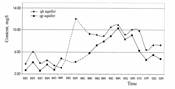
Figure 2. Diagram of the change of average
degree of oxidation in groundwater
in the south of
2) The polluted area is situated also in the south of
the city.
The results of preliminary study by Phạm Hùng Việt
(Centre of Environmental Chemistry, Hà Nội University of Natural Sciences,
2000) have been showing that the content of easily evaporated organic compounds
(benzene, toluene, xylene, chloric derivatives of hydrocarbon containing 1-3
atoms C) in groundwater is inconsiderable and under the permitted standards.
The content of polychlorbiphenyl and aromatic hydrocarbons has not been studied
yet.
c.
Microbiological pollution
The microbiological pollution, consisting of the content
of total Coliform (permitted standard: 0/100 ml) and Fecal coliform (permitted
standard: 0), has been studied by Đỗ Trọng Sự, Research Institute of Geology
and Mineral Resources, giving the results presented in the Table 4.
Table 4. Result of
determining microbiological content in groundwater in 1993 year
|
Season |
Holocene aquifer (qh) |
Pleistocene aquifer (qp) |
||||
|
Number of studied
samples |
Samples not meeting the
standard |
Ratio % |
Number of studied samples |
Samples not meeting the standard |
Ratio % |
|
|
Dry |
36 |
28 |
77 |
31 |
15 |
48 |
|
Rainy |
14 |
7 |
50 |
20 |
9 |
45 |
The results of
study have been showing that:
1) In both aquifers the microbiological content are
greater than the permitted standard, proving that the groundwater is polluted,
among this the pollution in qh aquifer is heavier than in qp aquifer, and the
pollution in dry season is heavier than in rainy season;
2) Groundwater is polluted mainly by Fecal coliform; in
most cases the content is from 3-10 to 100/100 ml.
d.
Pollution by heavy metals
The pollution by heavy
metals has been studied desultorily and unsystematically, therefore, we cannot
have a precise conclusion on the pollution, but only have the knowledge on
Table 5. Results of
the study on arsenic content in groundwater
during the dry season of 2000 and rainy season of 2001
|
Studied
areas |
Holocene
aquifer |
Pleistocene
aquifer |
|
|||
|
Dry
season of 2000 |
Rainy
season of 2001 |
Dry
season of 2000 |
Rainy
season of 2001 |
|||
|
Đông Anh District |
|
|
|
|
|
|
|
-Total of
studied samples - Number of samples higher
than the permitted standard - Ratio (%) |
|
|
78 6 7.7 |
|
0.105 |
|
|
Sóc Sơn District |
|
|
|
|
|
|
|
-Total of
studied samples - Number of samples higher
than the permitted standard - Ratio (%) |
|
|
37 1 2.7 |
|
0.196 |
|
|
Gia Lâm District |
|
|
|
|
|
|
|
-Total of
studied samples - Number of samples higher
than the permitted standard - Ratio (%) |
20 8 40 |
19 2 10.5 |
72 13 18.1 |
72 2 2.8 |
0.274 |
|
|
Thanh Trì District |
|
|
|
|
|
|
|
-Total of
studied samples - Number of samples higher
than the permitted standard - Ratio (%) |
72 43 59.5 |
72 29 40.3 |
24 13 54.2 |
23 9 39.1 |
0.292 |
|
|
Từ Liêm District |
|
|
|
|
|
|
|
-Total of
studied samples - Number of samples higher
than the permitted standard - Ratio (%) |
55 8 14.5 |
55 1 1.8 |
25 9 36 |
25 3 12 |
0.216 |
|
|
Urban area |
|
|
|
|
|
|
|
-Total of
studied samples - Number of samples higher
than the permitted standard - Ratio (%) |
47 18 38.3 |
46 12 26.1 |
42 17 39.5 |
43 8 19 |
0.331 |
|
the current status
of their content in groundwater. The most significant is the recent finding and
study on arsenic content. The main research works include:
In 1994, when
studying on the pollution of groundwater in Hà Nội, Đỗ Trọng Sự informed on
some samples having the arsenic content greater than the permitted standard (PS
= 0.05 mg/l).
In 1999, basing
on the discovery by some scientists the mass media informed on the arsenic
pollution of some water source at
The study on
arsenic content in groundwater has been realized rather sufficiently by the
DHGEN. Samples were collected with great quantity with 800 samples on the whole
city and in both dry (Dec., 2000) and rainy (Aug., 2001) seasons. The study was
carried out under the order of the UNICEF in Việt
The analysis of data of this Table shows that:
1) In the north of Red and Đuống rivers (Sóc Sơn and
Đông Anh Districts) only the qp aquifer is studied; the number of samples
having the arsenic content higher than the permitted standard is
inconsiderable;
2) In the south of the Red and Đuống rivers the number
of samples having the arsenic content higher than the permitted standard is
more numerous, occupying from 1.8 to 59.7% of the studied sample number;
3) In the Gia Lâm area the number of samples having the
arsenic content higher than the permitted standard of the qh aquifer is higher
than that of the qp aquifer. In the Từ Liêm area the arsenic content in the qp
aquifer is higher than that of the qh one; in the Thanh Trì and city interior
areas the two aquifers have the same degree of pollution;
4) In all the studied areas, during the dry season water
is more polluted by arsenic than in the rainy season.
2. Some problems of cause of pollution
The cause of groundwater pollution has not been studied
in detail yet, however, we can set forth the problems associated with each
pollution type as follows:
1) At present, the problem of environment pollution in
2) The studied area, especially the city interior, has
very many boreholes (water exploiting boreholes, exploration boreholes),
besides the exploitation of brick and tile clay, the excavation and stake
driving for construction, etc. create good conditions to the pollution,
especially the downward one.
3) The composition and origin of sediments can be the source
creating pollution factors, among them there are organic matters in the rocks
(mud, peat, etc.) that are the source of nitrogen compound and arsenic
pollution.
4) The strong exploitation of groundwater can be the
direct cause of pollution. It makes the water level deeply lowering, forming
large water lowering funnels accompanied by changes in hydrodynamic conditions,
such as current rate, hydrodynamic inclination, permeability, that can lead to
changes in physico-chemical conditions, strengthening the rate of groundwater
pollution.
REFERENCES
1.
Đỗ Trọng Sự, 1997. Hiện trạng ô nhiễm
nước dưới đất ở một số khu dân cư kinh tế quan trọng thuộc đồng bằng Bắc Bộ. (Current status of
groundwater pollution in some important population and industrial areas in the
Bắc Bộ Plain). Báo cáo Hội thảo Tài nguyên
nước dưới đất: 99-112. Hà Nội.
2. Phạm Hùng Việt, 2002. Chất lượng nước ngầm vùng Hà
Nội. (Quality of groundwater in the Hà
Nội area). Báo cáo Hội thảo về
nước ngầm Hà Nội. Bộ Kế hoạch và Đầu tư, Hà Nội. .
3. UNICEF Việt Nam,
2002.
Hướng tới giảm nhẹ sự ô nhiễm arsen ở
Việt Nam. (To the mitigation of
arsenic pollution in Việt Nam). Báo
cáo Hội thảo xây dựng chương trình hành động về arsen, Bộ Nông nghiệp và Phát
triển nông thôn, Hà Nội.
4. Vũ Nhật Thắng,
Nguyễn Văn Đản, 2004. Địa chất và tài nguyên khoáng sản thành phố Hà Nội. (Geology and mineral
resources of Hà Nội City). Cục Địa chất và Khoáng
sản Việt Nam. Hà Nội.